School nearby Anas bin Nadr Elementary
Saudi Arabia
School nearby Anas bin Nadr Elementary
Anas bin Nadr Elementary
أحمد شوقي, 47321, Tabuk, SA Saudi Arabia
contacts phone
:
+966 14 443 3930
Latitude:
28.4370204
, Longitude:
36.5346533
larger map & directions
read more
nearest School
309 m
الابتدائية الثامنه والاربعون
4027 الوفاء, Tabuk
School
read more
339 m
مدرسة التربية الخاصة للتوحد الاهلية
3347 Ahmad Shawqi, Tabuk
School
read more
448 m
Thirty Girls Medium
المصيف ١, Tabuk
School
read more
464 m
الثانوية الحادية والعشرون
4072, Tabuk
School
read more
488 m
الابتدائية الخامسة والستون بنات تحفيظ
4072, Tabuk
School
read more
504 m
الروضة السادسة
Tabuk
School
read more
519 m
المدرسة الخامسة لتحفيظ القران الكريم
المصيف،تبوك
School
read more
528 m
مركز الموهوبات بتبوك
6888, Tabuk
School
read more
863 m
Schools generations Tbok.palmsif Tabuk
7246 سليمان بن هشام, Tabuk
School
read more
1.193 km
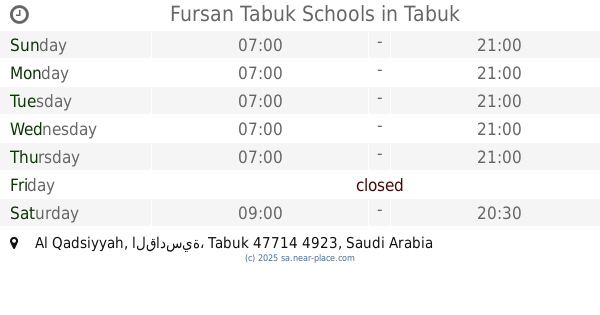
مدارس فرسان تبوك الاهلية
8080, القادسية، 4939, Tabuk
School
read more
1.206 km
مدرسة فرسان
8109, Tabuk
School
read more
1.21 km
Fursan Tabuk Schools
8069, Al Qadsiyyah, Tabuk
School
read more
1.306 km
Elite schools of civil buds
7595, Tabuk
School
read more
1.313 km
Private School for Autism
8526, Tabuk
School
read more
1.329 km
Son of Brig.
Tabuk
School
read more
1.444 km
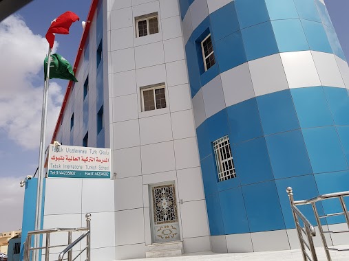
Turkish International School
5494, Al Qadsiyyah, Tabuk
School
read more
1.454 km
الابتدائية ٧١ الواحد والسبعون
4747, Tabuk
School
read more
1.462 km
المدرسة التركية 🇹🇷
Tabuk
School
read more
1.463 km
Thirty high school girls
4747, Tabuk
School
read more
1.486 km
المدرسة التركية العالمية بتبوك
6953, Tabuk
School
read more
1.499 km
الروضة السادسة عشر
Tabuk
School
read more
1.507 km
مدرسة ابن العميد الثانوية
Tabuk
School
read more
1.509 km
المتوسطة الاثنان والاربعون
4747, Tabuk
School
read more
1.51 km
المتوسطة الثانية و الأربعون -بنات
4747, Tabuk
School
read more
1.52 km
ثانوية ابن العميد
Tabuk
School
read more
📑
all categories
Accounting
Administrative area level 1
Airport
Amusement park
Aquarium
Art gallery
Atm
Bakery
Bank
Bar
Beauty salon
Bicycle store
Book store
Bowling alley
Bus station
Cafe
Campground
Car dealer
Car rental
Car repair
Car wash
Casino
Cemetery
Church
City hall
Clothing store
Colloquial area
Convenience store
Country
Courthouse
Dentist
Department store
Doctor
Electrician
Electronics store
Embassy
Finance
Fire station
Florist
Food
Funeral home
Furniture store
Gas station
General contractor
Grocery or supermarket
Gym
Hair care
Hardware store
Health
Hindu Temple
Home goods store
Hospital
Insurance agency
Intersection
Jewelry store
Laundry
Lawyer
Library
Light rail station
Liquor store
Local government office
Locality
Locksmith
Lodging
Meal delivery
Meal takeaway
Mosque
Movie rental
Movie theater
Moving company
Museum
Natural feature
Neighborhood
Night club
Painter
Park
Parking
Pet store
Pharmacy
Physiotherapist
Place of worship
Plumber
Point of interest
Police
Political
Post office
Premise
Real estate agency
Restaurant
Roofing contractor
Route
Rv park, camping
School
Shoe store
Shopping mall
Spa
Stadium
Storage
Store
Sublocality
Subpremise
Subway station
Supermarket
Taxi stand
Train station
Transit station
Travel agency
University
Veterinary care
Zoo
sublocality level 1
↑