School nearby Girls Primary School 33
Saudi Arabia
School nearby Girls Primary School 33
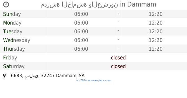
Girls Primary School 33
Shabeeb Ibn Ghaleb Street, 32247, Dammam, SA Saudi Arabia
contacts phone
:
+966
Latitude:
26.4230087
, Longitude:
50.0694662
larger map & directions
read more
nearest School
25 m
Thirty School in Dammam
Nabyaniyah Street, Dammam
School
read more
78 m
المدرسة العاشرة المتوسطة للبنات
القادسية،, Dammam
School
read more
88 m
الثانوية الثامنة عشر بالدمام
3832 Ar Ras, Dammam
School
read more
349 m
ثانوية عكاظ
Dammam
School
read more
357 m
Exams
Dammam
School
read more
421 m
أبي حنيفة الابتدائية
3931 الثمامة, 7039, Dammam
School
read more
430 m
مدرسة ابى حنيفة الابتدآئية
Shaddad Ibn Aws Street, Dammam
School
read more
448 m
مركز خدمة المجتمع والتدريب المستمر بالمنطقة الشرقية
القادسية،, Dammam
School
read more
494 m
فرع الكلية التقنية College of Technology Branch
Dammam
School
read more
505 m
Intermediate School Ain Jalut
4020 صفوان بن اسيد, 6931, Dammam
School
read more
577 m
Adan Uniform Shop
7988 Prince Nayef Bin Abdulaziz Road, Dammam
School
read more
581 m
AFJAL KHAN
Prince Nayef Bin Abdulaziz Road, Dammam
School
read more
633 m
مدارس الإيمان الأهلية
Dammam
School
read more
636 m
مدارس طيبة الإسلام
Dammam
School
read more
648 m
مسجد مرزوقه
Khafji
School
read more
649 m
مدارس الإيمان الأهلية
3931 Abu Al Hasan Al Wasty, Dammam
School
read more
656 m
مركز الطموح والأمل بالدمام
Dammam
School
read more
675 m
مدرسة التاسع و العشرون
شارع 18 ب، غرناطة،, Dammam
School
read more
675 m
مدرسة 29
شارع 18 ب، غرناطة،, Dammam
School
read more
720 m
المدرسة الثانوية الخامسة للبنات
الدمام
School
read more
733 m
المدرسة 29 الابتدائية للبنات
4624 سعد بن معاذ, Dammam
School
read more
739 m
المدرسة الابتدائية الخامسة والعشرون
6635 سلوى, 4023, Dammam
School
read more
741 m
مدرسة الخامسة والعشرون
6683 سلوى, Dammam
School
read more
753 m
Minor Seventh Girls Dammam
4627 سعد بن معاذ, 7243, Dammam
School
read more
768 m
Imam Shafi'i Elementary School
Dammam
School
read more
📑
all categories
Accounting
Administrative area level 1
Airport
Amusement park
Aquarium
Art gallery
Atm
Bakery
Bank
Bar
Beauty salon
Bicycle store
Book store
Bowling alley
Bus station
Cafe
Campground
Car dealer
Car rental
Car repair
Car wash
Casino
Cemetery
Church
City hall
Clothing store
Colloquial area
Convenience store
Country
Courthouse
Dentist
Department store
Doctor
Electrician
Electronics store
Embassy
Finance
Fire station
Florist
Food
Funeral home
Furniture store
Gas station
General contractor
Grocery or supermarket
Gym
Hair care
Hardware store
Health
Hindu Temple
Home goods store
Hospital
Insurance agency
Intersection
Jewelry store
Laundry
Lawyer
Library
Light rail station
Liquor store
Local government office
Locality
Locksmith
Lodging
Meal delivery
Meal takeaway
Mosque
Movie rental
Movie theater
Moving company
Museum
Natural feature
Neighborhood
Night club
Painter
Park
Parking
Pet store
Pharmacy
Physiotherapist
Place of worship
Plumber
Point of interest
Police
Political
Post office
Premise
Real estate agency
Restaurant
Roofing contractor
Route
Rv park, camping
School
Shoe store
Shopping mall
Spa
Stadium
Storage
Store
Sublocality
Subpremise
Subway station
Supermarket
Taxi stand
Train station
Transit station
Travel agency
University
Veterinary care
Zoo
sublocality level 1
↑