School nearby Intermediate School
Coronavirus disease (COVID-19) Situation
confirmed cases
841469
deaths
9646
Saudi Arabia
School nearby Intermediate School
Intermediate School
Tabuk Province Saudi Arabia
contacts phone
:
+966
Latitude:
28.4654035
, Longitude:
36.5658011
read more
nearest School
387 m
حي الرابية
Saudi Arabia
School
read more
434 m
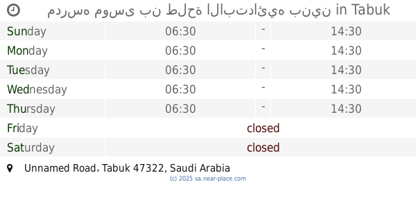
مدرسه موسى بن طلحة الابتدائيه بنين
Unnamed Road, Tabuk
School
read more
678 m
School Musa Bin Talha
5467, مخطط الرابية،, Tabuk
School
read more
1.085 km
Average Fatima Zahra Girls
4599, مخطط الرابية, Tabuk
School
read more
1.194 km
المدرسه المتوسطه حي الريان
Tabuk
School
read more
1.194 km
المدرسه المتوسطه بنات
Tabuk
School
read more
1.555 km
Sixty-fourth school Primary Girls
4208, مخطط الرابية, Tabuk
School
read more
2.737 km
الروضة السادسة عشر
King Faisal Road, Tabuk
School
read more
2.772 km
روضة 16
Almasif،, Unnamed Road, Tabuk
School
read more
2.89 km
المتوسطة الثانية و الأربعون -بنات
4747, Tabuk
School
read more
2.891 km
المتوسطة الاثنان والاربعون
4747, Tabuk
School
read more
2.896 km
الروضة السادسة عشر
Tabuk
School
read more
2.939 km
Thirty high school girls
4747, Tabuk
School
read more
2.943 km
الابتدائية ٧١ الواحد والسبعون
4747, Tabuk
School
read more
2.955 km
Al Qassaem International School
Tabuk
School
read more
2.977 km
Mosque of Ibn Yasin neighborhood resort 3
Tabuk
School
read more
3.012 km
مسجد عاصم بن عمر رضي الله عنه
تبوك
School
read more
3.02 km
مدرسة الليث بن سعد المتوسطة
5040, Tabuk
School
read more
3.129 km
مدارس تبوك العالمية
Tabuk
School
read more
3.214 km
الثانوية العشرون
7926, Tabuk
School
read more
3.243 km
Girls Preparatory School
7896, Tabuk
School
read more
3.244 km
المدرسه المتوسطه بنات
مروج الأمير, Tabuk
School
read more
3.275 km
Thirty-Second Intermediate Girls
7896, 3128, Tabuk
School
read more
3.275 km
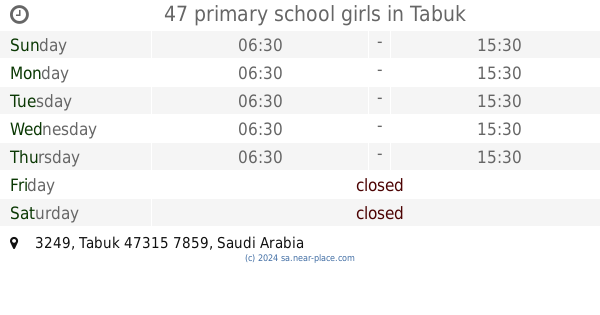
47 primary school girls
3249, Tabuk
School
read more
3.328 km
Son of Brig.
Tabuk
School
read more
📑
all categories
Accounting
Administrative area level 1
Airport
Amusement park
Aquarium
Art gallery
Atm
Bakery
Bank
Bar
Beauty salon
Bicycle store
Book store
Bowling alley
Bus station
Cafe
Campground
Car dealer
Car rental
Car repair
Car wash
Casino
Cemetery
Church
City hall
Clothing store
Colloquial area
Convenience store
Country
Courthouse
Dentist
Department store
Doctor
Electrician
Electronics store
Embassy
Finance
Fire station
Florist
Food
Funeral home
Furniture store
Gas station
General contractor
Grocery or supermarket
Gym
Hair care
Hardware store
Health
Hindu Temple
Home goods store
Hospital
Insurance agency
Intersection
Jewelry store
Laundry
Lawyer
Library
Light rail station
Liquor store
Local government office
Locality
Locksmith
Lodging
Meal delivery
Meal takeaway
Mosque
Movie rental
Movie theater
Moving company
Museum
Natural feature
Neighborhood
Night club
Painter
Park
Parking
Pet store
Pharmacy
Physiotherapist
Place of worship
Plumber
Point of interest
Police
Political
Post office
Premise
Real estate agency
Restaurant
Roofing contractor
Route
Rv park, camping
School
Shoe store
Shopping mall
Spa
Stadium
Storage
Store
Sublocality
Subpremise
Subway station
Supermarket
Taxi stand
Train station
Transit station
Travel agency
University
Veterinary care
Zoo
sublocality level 1
↑