School nearby كلية العلوم الطبيه قسم المختبرات بنات جامعة تبوك
Saudi Arabia
School nearby كلية العلوم الطبيه قسم المختبرات بنات جامعة تبوك
كلية العلوم الطبيه قسم المختبرات بنات جامعة تبوك
Tabuk Saudi Arabia
contacts phone
:
+966
Latitude:
28.3962701
, Longitude:
36.541504
read more
nearest School
34 m
University of Tabuk, Al Dhakl Campus
Tabuk
School
read more
359 m
مسرح الإدارات النسائيه
Tabuk
School
read more
373 m
متوسطة خبيب بن عدي
عين اليمامة, Tabuk
School
read more
378 m
مسرح الإدارات النسائية بتعليم تبوك
Tabuk
School
read more
382 m
Ahmed Ibn Hanbal Primary
ناصر بن ابي المكارم, Tabuk
School
read more
395 m
الابتدائية الثالثة والأربعون
تبوك
School
read more
413 m
المدرسة الرابعة والاربعون
9195-9219 Al Kuwait, Tabuk
School
read more
445 m
المتوسطة الخامسة والثلاثون في تبوك
4502 Ayn Jalut, Tabuk
School
read more
491 m
School Uqba Primary
الافلاج, Tabuk
School
read more
505 m
مدرسة الستون الأبتدتئيه.
Tabuk
School
read more
508 m
المدرسة السادسة
9197, Tabuk
School
read more
531 m
ادارة الشؤون الأكاديمية
King Abdullah Ibn Abdul Aziz Road, Tabuk
School
read more
539 m
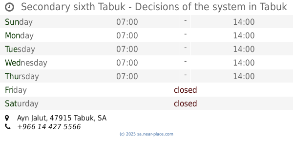
Secondary sixth Tabuk - Decisions of the system
Ayn Jalut, Tabuk
School
read more
556 m
مركز الشئون الاكاديمية والتدريب
King Abdullah Ibn Abdul Aziz Road, Tabuk
School
read more
691 m
Kindergarten Eighth
4195, Tabuk
School
read more
692 m
الابتدائية الحادية والعشرون بتبوك
4195, Tabuk
School
read more
724 m
دار البيان
4350 طلحة بن مالك, Tabuk
School
read more
763 m
وحدة علم النفس العيادي بتبوك
7315 عمر بن الخطاب, 7289-, Tabuk
School
read more
772 m
الروضة الثانية والعشرون
3955-3977 الفوهة،, Tabuk
School
read more
778 m
Ohid Elementary School
Tabuk
School
read more
806 m
التحفيظ دار البيان
9569, Tabuk
School
read more
851 m
Thirty Girls Primary School
9376, Tabuk
School
read more
982 m
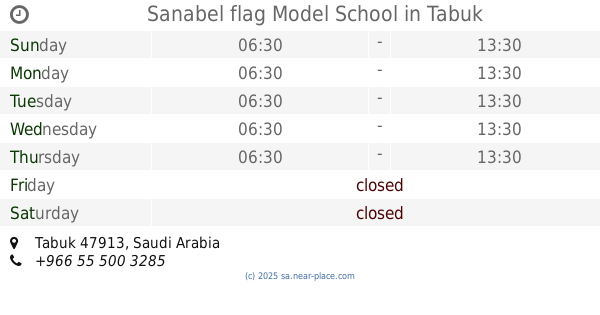
Sanabel flag Model School
Tabuk
School
read more
1.001 km
Abu Bakr Siddiq School
Tabuk
School
read more
1.038 km
مدرسة بشر بن معاوية الابتدائية
4500, Tabuk
School
read more
📑
all categories
Accounting
Administrative area level 1
Airport
Amusement park
Aquarium
Art gallery
Atm
Bakery
Bank
Bar
Beauty salon
Bicycle store
Book store
Bowling alley
Bus station
Cafe
Campground
Car dealer
Car rental
Car repair
Car wash
Casino
Cemetery
Church
City hall
Clothing store
Colloquial area
Convenience store
Country
Courthouse
Dentist
Department store
Doctor
Electrician
Electronics store
Embassy
Finance
Fire station
Florist
Food
Funeral home
Furniture store
Gas station
General contractor
Grocery or supermarket
Gym
Hair care
Hardware store
Health
Hindu Temple
Home goods store
Hospital
Insurance agency
Intersection
Jewelry store
Laundry
Lawyer
Library
Light rail station
Liquor store
Local government office
Locality
Locksmith
Lodging
Meal delivery
Meal takeaway
Mosque
Movie rental
Movie theater
Moving company
Museum
Natural feature
Neighborhood
Night club
Painter
Park
Parking
Pet store
Pharmacy
Physiotherapist
Place of worship
Plumber
Point of interest
Police
Political
Post office
Premise
Real estate agency
Restaurant
Roofing contractor
Route
Rv park, camping
School
Shoe store
Shopping mall
Spa
Stadium
Storage
Store
Sublocality
Subpremise
Subway station
Supermarket
Taxi stand
Train station
Transit station
Travel agency
University
Veterinary care
Zoo
sublocality level 1
↑