School nearby كلية الطب والجراحة
Saudi Arabia
School nearby كلية الطب والجراحة
كلية الطب والجراحة
2546, 8162, Taif Saudi Arabien
contacts phone
:
+966
Latitude:
21.4291651
, Longitude:
40.4735135
read more
nearest School
101 m
College of Pharmacy
8237, Taif
School
read more
205 m
مبنى السنة التحضيرية للمسار الصحي
2322, 7997, Taif
School
read more
280 m
Faculty of Medicine - Female
2546, Taif
School
read more
343 m
Building 2 Taif university girls
8359, Taif
School
read more
474 m
Taif Books Client
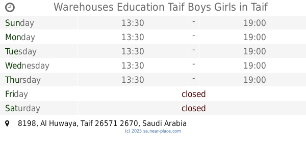
8198, 2670, Taif
School
read more
480 m
ابتدائية أجنادين للبنين
Al Huwaya
School
read more
525 m
مدرسة أم حبيبة الابتدائية (بنات)
2616, 7778, Taif
School
read more
537 m
ابتدائية حبيبة بنت أسد
2616, Taif
School
read more
537 m
ابتدائية أم حبيبة بنت أسد
2616, Taif
School
read more
552 m
Warehouses Education Taif Boys Girls
8198, Taif
School
read more
689 m
مركز الطفولة النموذجي
Unnamed Road, Taif
School
read more
829 m
Qadisiyah Elementary School For Boys
Taif
School
read more
836 m
الروضة والابتدائية الأولى بالحوية
Taif
School
read more
839 m
Qadisiyah elementary Bahoih
2440, Taif
School
read more
884 m
The first medium Bahoih for Girls
3، الجبيل
School
read more
886 m
الثانوية الأولى بالحويه
8046, Taif
School
read more
1.052 km
مستودعات جامعة الطائف
Taif
School
read more
1.075 km
روضة وحضانة البراعم
Taif
School
read more
1.137 km
Forth intermediate school in al huwaya
Taif
School
read more
1.163 km
مركز أم حبيبية النسائي
21.4282683,40
School
read more
1.176 km
Forth secondary school in al hawiyah
2924, Taif
School
read more
1.223 km
مدرسه اوس بن الصامت بنين
شارع الستين, Taif
School
read more
1.228 km
Kindergarten glory
6631, Taif
School
read more
1.276 km
روضة دار الفكر التربوي
6519, Taif
School
read more
1.286 km
School second memorization Bahoih (Girls)
7224, Taif
School
read more
📑
all categories
Accounting
Administrative area level 1
Airport
Amusement park
Aquarium
Art gallery
Atm
Bakery
Bank
Bar
Beauty salon
Bicycle store
Book store
Bowling alley
Bus station
Cafe
Campground
Car dealer
Car rental
Car repair
Car wash
Casino
Cemetery
Church
City hall
Clothing store
Colloquial area
Convenience store
Country
Courthouse
Dentist
Department store
Doctor
Electrician
Electronics store
Embassy
Finance
Fire station
Florist
Food
Funeral home
Furniture store
Gas station
General contractor
Grocery or supermarket
Gym
Hair care
Hardware store
Health
Hindu Temple
Home goods store
Hospital
Insurance agency
Intersection
Jewelry store
Laundry
Lawyer
Library
Light rail station
Liquor store
Local government office
Locality
Locksmith
Lodging
Meal delivery
Meal takeaway
Mosque
Movie rental
Movie theater
Moving company
Museum
Natural feature
Neighborhood
Night club
Painter
Park
Parking
Pet store
Pharmacy
Physiotherapist
Place of worship
Plumber
Point of interest
Police
Political
Post office
Premise
Real estate agency
Restaurant
Roofing contractor
Route
Rv park, camping
School
Shoe store
Shopping mall
Spa
Stadium
Storage
Store
Sublocality
Subpremise
Subway station
Supermarket
Taxi stand
Train station
Transit station
Travel agency
University
Veterinary care
Zoo
sublocality level 1
↑