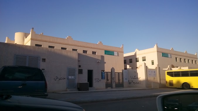
School nearby مدرسة الامير نايف
Saudi Arabia
School nearby مدرسة الامير نايف
مدرسة الامير نايف
Wadi Ad Dawasir, 13261, Riyadh, SA Saudi Arabia
contacts phone
:
+966
Latitude:
24.8235431
, Longitude:
46.8219119
larger map & directions
read more
nearest School
1.011 km
الخسف السعودية
4432, Riyadh
School
read more
1.112 km
School and Kindergarten Read
3754, Riyadh
School
read more
1.113 km
مدرسة و روضة إقرأ النسائية
3754, Riyadh
School
read more
1.138 km
ابتدائية ثابت بن عامر
7296, Riyadh
School
read more
1.14 km
ابتدائية سلافة بنت سعد بنات
7296, Riyadh
School
read more
1.146 km
Fixed Ben Amer and secondary schools Aptdiah
7296, Riyadh
School
read more
1.175 km
Secondary Prince Fawaz bin Abdulaziz
7296, Riyadh
School
read more
1.187 km
متوسطة ام حبيب بنت العباس بنات
Riyadh
School
read more
1.276 km
مدرسة خديجة بنت خويلد
4019, Riyadh
School
read more
1.532 km
مدرسة مسلم بن يسار المتوسطة
3687, 6890, Riyadh
School
read more
1.554 km
دار ازهار البيان
3777, Riyadh
School
read more
1.559 km
متوسطة مسلم بن يسار
3687, Riyadh
School
read more
1.576 km
Elementary Khalid bin Zaid
3687, Riyadh
School
read more
1.578 km
ثانوية محمد الفاتح بالرياض
2512, Riyadh
School
read more
1.593 km
ثانوية محمد الفاتح
3154 Al Mujaimir, 7417, Riyadh
School
read more
1.604 km
مدرسة خالد بن زيد الابتدائية بالرياض
3667, 6790, Riyadh
School
read more
1.606 km
Mohammed Al Fateh School
2512, Riyadh
School
read more
1.623 km
متوسطة مسلم بن بسار
7005, Riyadh
School
read more
1.665 km
Mhdast Elrmal For Girls And Boy
Riyadh
School
read more
1.668 km
موارد المستقبل للتدريب
وادي الساحل،, Riyadh
School
read more
1.678 km
المعسكر الكشفي الدائم
8770 علي بن حمود, 4430, Riyadh
School
read more
1.849 km
متوسطة سارة بنت عبدالعزيز
Riyadh
School
read more
1.901 km
Adwaa Alriyadh Schools
Ashaikh Jaber Alahmed Alsabah, Riyadh
School
read more
2.007 km
Authorized contracts for the marriages
محمد الحريري البصري, Riyadh
School
read more
2.081 km
دار الثريا لتحفيظ القران الكريم
Riyadh
School
read more
📑
all categories
Accounting
Administrative area level 1
Airport
Amusement park
Aquarium
Art gallery
Atm
Bakery
Bank
Bar
Beauty salon
Bicycle store
Book store
Bowling alley
Bus station
Cafe
Campground
Car dealer
Car rental
Car repair
Car wash
Casino
Cemetery
Church
City hall
Clothing store
Colloquial area
Convenience store
Country
Courthouse
Dentist
Department store
Doctor
Electrician
Electronics store
Embassy
Finance
Fire station
Florist
Food
Funeral home
Furniture store
Gas station
General contractor
Grocery or supermarket
Gym
Hair care
Hardware store
Health
Hindu Temple
Home goods store
Hospital
Insurance agency
Intersection
Jewelry store
Laundry
Lawyer
Library
Light rail station
Liquor store
Local government office
Locality
Locksmith
Lodging
Meal delivery
Meal takeaway
Mosque
Movie rental
Movie theater
Moving company
Museum
Natural feature
Neighborhood
Night club
Painter
Park
Parking
Pet store
Pharmacy
Physiotherapist
Place of worship
Plumber
Point of interest
Police
Political
Post office
Premise
Real estate agency
Restaurant
Roofing contractor
Route
Rv park, camping
School
Shoe store
Shopping mall
Spa
Stadium
Storage
Store
Sublocality
Subpremise
Subway station
Supermarket
Taxi stand
Train station
Transit station
Travel agency
University
Veterinary care
Zoo
sublocality level 1
↑