School nearby مدرسة بنات ام كلثوم بنت النبي
Saudi Arabia
School nearby مدرسة بنات ام كلثوم بنت النبي
مدرسة بنات ام كلثوم بنت النبي
Manfouha, Riyadh Saudi Arabia
contacts phone
:
+966
Latitude:
24.651407
, Longitude:
46.5548672
read more
nearest School
65 m
متوسطة أم كلثوم
ظهرة لبن،, Riyadh
School
read more
77 m
ابتدائية امامه بنت ابي العاص
شارع وعله، ظهرة لبن،, Riyadh
School
read more
104 m
مدرسه امامه بنت العاص للبنات
Riyadh
School
read more
125 m
مدرسة حكمة النسائية لتحفيظ القرآن الكريم
Waala Street, Riyadh
School
read more
378 m
شراء الاثاث المستعمل الرياض
شارع وعله، ظهرة لبن، الرياض 13751،
School
read more
488 m
مدارس المطورون الأهلية ( بنات )
9265 كدمان, 3286, Riyadh
School
read more
577 m
إستضافة الياسمين
Riyadh
School
read more
663 m
استراحة جبران الفرد
Riyadh
School
read more
820 m
Knights of learning schools (Preliminary - Elementary)
2648 ثرمدا, Riyadh
School
read more
1.159 km
Harith bin US School
5029 مصافي, Riyadh
School
read more
1.167 km
دار عاتكة
3130-3223 ينبع،, Riyadh
School
read more
1.173 km
مدرسة قيس بن السائب الإبتدائية
5052, Riyadh
School
read more
1.181 km
دار عاتكة بنت عبدالمطلب النسائية لتعليم القرآن
ظهرة لبن،, Riyadh
School
read more
1.227 km
مدرسة سالم بن عبدالله الابتدائية
8769 غنيمة, Riyadh
School
read more
1.235 km
مخطط مدرسة بنين
Riyadh
School
read more
1.235 km
مخطط مدرسة بنين
Dhahrat Laban
School
read more
1.236 km
Salem bin Abdullah Elementary school- Boys
8786 Qandahar, Riyadh
School
read more
1.237 km
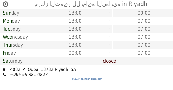
مدرسة اليعقوبي الثانوية
4032 Al Quba, Riyadh
School
read more
1.245 km
MAKTABT.COM BOOKSTORE
Riyadh
School
read more
1.253 km
مركز التميز للرعاية النهارية
4032 Al Quba, Riyadh
School
read more
1.271 km
مدارس الرواد التعلم
Taif Taif, Riyadh
School
read more
1.287 km
مدارس رواد التعلم للبنات
2197 Taif, Riyadh
School
read more
1.304 km
مدارس المطورون الأهلية
قندهار ,ظهره لبن، Riyadh
School
read more
1.304 km
مدارس المطورون الأهلية
قندهار ,ظهره لبن، الرياض
School
read more
1.415 km
مدرسة عبدالله بن أسلم المتوسطة
3912 غزة, Riyadh
School
read more
📑
all categories
Accounting
Administrative area level 1
Airport
Amusement park
Aquarium
Art gallery
Atm
Bakery
Bank
Bar
Beauty salon
Bicycle store
Book store
Bowling alley
Bus station
Cafe
Campground
Car dealer
Car rental
Car repair
Car wash
Casino
Cemetery
Church
City hall
Clothing store
Colloquial area
Convenience store
Country
Courthouse
Dentist
Department store
Doctor
Electrician
Electronics store
Embassy
Finance
Fire station
Florist
Food
Funeral home
Furniture store
Gas station
General contractor
Grocery or supermarket
Gym
Hair care
Hardware store
Health
Hindu Temple
Home goods store
Hospital
Insurance agency
Intersection
Jewelry store
Laundry
Lawyer
Library
Light rail station
Liquor store
Local government office
Locality
Locksmith
Lodging
Meal delivery
Meal takeaway
Mosque
Movie rental
Movie theater
Moving company
Museum
Natural feature
Neighborhood
Night club
Painter
Park
Parking
Pet store
Pharmacy
Physiotherapist
Place of worship
Plumber
Point of interest
Police
Political
Post office
Premise
Real estate agency
Restaurant
Roofing contractor
Route
Rv park, camping
School
Shoe store
Shopping mall
Spa
Stadium
Storage
Store
Sublocality
Subpremise
Subway station
Supermarket
Taxi stand
Train station
Transit station
Travel agency
University
Veterinary care
Zoo
sublocality level 1
↑