School nearby مدرسة حسن بن علي الابتدائية
Coronavirus disease (COVID-19) Situation
confirmed cases
841469
deaths
9646
Saudi Arabia
School nearby مدرسة حسن بن علي الابتدائية
مدرسة حسن بن علي الابتدائية
An Nasiriyah, Arar 73241, Saudi Arabia
contacts phone
:
+966
Latitude:
30.9699915
, Longitude:
41.0388249
larger map & directions
read more
nearest School
136 m
The 6th Elementary School
Arar
School
read more
207 m
معهد حروف الشمال
8276 القاهره, An Nasriyah, 3272, Arar
School
read more
285 m
Secondary Mecca
3474 القاهره, Arar
School
read more
377 m
الثانوية الثامنة
7901, Arar
School
read more
385 m
The 10th Intermediate School
An Nasiriyah
School
read more
388 m
مدارس بنات الغد الأهلية
Arar
School
read more
392 m
The 8th Scondary School
An Nasiriyah
School
read more
412 m
شركة مدارس بنات الغد الأهلية
Arar
School
read more
458 m
التاسعة والعشرون الابتدائية للبنات
حي الناصرية،, Arar
School
read more
502 m
مدرسة الملك سعود الثانوية
An Nasiriyah
School
read more
505 m
King Saud School
7629 ابن النفيس, Arar
School
read more
600 m
مدرسة الإمام عاصم لتحفيظ القرآن الكريم
Arar
School
read more
698 m
متوسطة الأمير سلطان
5342-5324 Prince Abdulaziz Bin Musaed Road, Arar
School
read more
701 m
الثانوية الخامسة مقرارة
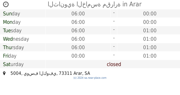
5004 يوسف الكوفي, الريان، 7549, Arar
School
read more
725 m
8th Intermediate School
Arar Industrial Zone
School
read more
728 m
مدرسة المتوسطة الثامنه
Arar
School
read more
730 m
متوسطة الثامنه
4985 يوسف الكوفي, الريان، 7616, Arar
School
read more
772 m
Prince Abdullah Bin Mosaad Intermediate School
An Nasiriyah
School
read more
778 m
مدرسة الامير عبدالله بن مساعد المتوسطة
7687 ابن ام كلثوم, Arar
School
read more
780 m
Secondary Ibn Khaldun Arar
5289, Arar
School
read more
854 m
ثانوية الشيخ محمد بن عثيمين
7502, AR Rayyan, Arar
School
read more
874 m
King Abdulaziz Primary School
Arar
School
read more
899 m
Primary School Imam Shafi'i
3867, Arar
School
read more
912 m
مركز الموهوبين بعرعر
73241،, Arar
School
read more
920 m
دار بتلاء رحمها الله النسائية لتحفيظ القرآن الكريم
4555، الريان، عرعر 73311
School
read more
📑
all categories
Accounting
Administrative area level 1
Airport
Amusement park
Aquarium
Art gallery
Atm
Bakery
Bank
Bar
Beauty salon
Bicycle store
Book store
Bowling alley
Bus station
Cafe
Campground
Car dealer
Car rental
Car repair
Car wash
Casino
Cemetery
Church
City hall
Clothing store
Colloquial area
Convenience store
Country
Courthouse
Dentist
Department store
Doctor
Electrician
Electronics store
Embassy
Finance
Fire station
Florist
Food
Funeral home
Furniture store
Gas station
General contractor
Grocery or supermarket
Gym
Hair care
Hardware store
Health
Hindu Temple
Home goods store
Hospital
Insurance agency
Intersection
Jewelry store
Laundry
Lawyer
Library
Light rail station
Liquor store
Local government office
Locality
Locksmith
Lodging
Meal delivery
Meal takeaway
Mosque
Movie rental
Movie theater
Moving company
Museum
Natural feature
Neighborhood
Night club
Painter
Park
Parking
Pet store
Pharmacy
Physiotherapist
Place of worship
Plumber
Point of interest
Police
Political
Post office
Premise
Real estate agency
Restaurant
Roofing contractor
Route
Rv park, camping
School
Shoe store
Shopping mall
Spa
Stadium
Storage
Store
Sublocality
Subpremise
Subway station
Supermarket
Taxi stand
Train station
Transit station
Travel agency
University
Veterinary care
Zoo
sublocality level 1
↑