School nearby مخيم الاد نامر البقوم
Coronavirus disease (COVID-19) Situation
confirmed cases
841469
deaths
9646
Saudi Arabia
School nearby مخيم الاد نامر البقوم
مخيم الاد نامر البقوم
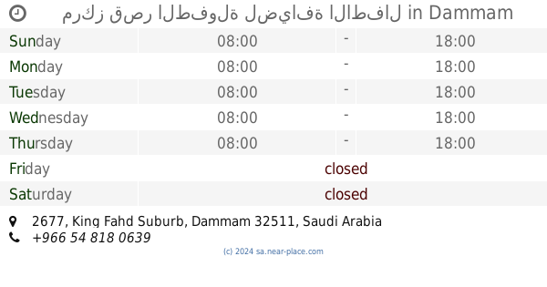
Al Matar, Dammam 32335, Saudi-Arabien
contacts phone
:
+966 54 667 8531
Latitude:
26.3936179
, Longitude:
49.9523885
larger map & directions
read more
nearest School
1.07 km
مدرسه مارسه القطبيه الابتداي
Dammam
School
read more
2.524 km
Nariyah university college
Dammam
School
read more
2.524 km
Sheng Lorenzo Jammang
dammam, Dammam
School
read more
2.524 km
,+966
Dammam
School
read more
2.524 km
الثاوية للكبيرات
Dammam
School
read more
2.524 km
Al Magda International School
Dammam
School
read more
2.524 km
السابعة والاربعون للبنات
Dammam
School
read more
2.525 km
هطش
Dammam
School
read more
2.53 km
cegent chanaIah
Dammam
School
read more
3.372 km
ابتدائية عائشة بنت أبي بكر
Unnamed Road, Dammam
School
read more
3.519 km
مدرسة عبادة بن بشر
Dammam
School
read more
3.642 km
مدرسة أم العلاء الأنصارية النسائية
الدمام
School
read more
3.729 km
Medium Marwa
Unnamed Road الفرسان, Dammam
School
read more
4.388 km
Bala Vikas Dammam
Dammam
School
read more
4.788 km
ابو تاكي
Dammam
School
read more
5.181 km
مركز وقت الابتسامة لضيافة الاطفال
Unnamed Road, Dammam
School
read more
5.269 km
مدرسه شموع المل
4286, Dammam
School
read more
5.342 km
Small minimum hospitality center for children
ضاحية الملك فهد،, Dammam
School
read more
5.36 km
ثانوية ام سلمه
Unnamed Road, Dammam
School
read more
5.856 km
Your child custody kingdom
4769, Dammam
School
read more
6.016 km
Deem story
ضاحية الملك فهد،, Dammam
School
read more
6.021 km
مركز حكاية ديم
ضاحية الملك فهد،, Dammam
School
read more
6.062 km
مركز قصر الطفولة لضيافة الاطفال
2677, Dammam
School
read more
6.194 km
روضة اجيال المستقبل بالضاحيه
الدمام,ضاحية الملك فهد
School
read more
6.195 km
اجيال المستقبل
ضاحية الملك فهد،, Dammam
School
read more
📑
all categories
Accounting
Administrative area level 1
Airport
Amusement park
Aquarium
Art gallery
Atm
Bakery
Bank
Bar
Beauty salon
Bicycle store
Book store
Bowling alley
Bus station
Cafe
Campground
Car dealer
Car rental
Car repair
Car wash
Casino
Cemetery
Church
City hall
Clothing store
Colloquial area
Convenience store
Country
Courthouse
Dentist
Department store
Doctor
Electrician
Electronics store
Embassy
Finance
Fire station
Florist
Food
Funeral home
Furniture store
Gas station
General contractor
Grocery or supermarket
Gym
Hair care
Hardware store
Health
Hindu Temple
Home goods store
Hospital
Insurance agency
Intersection
Jewelry store
Laundry
Lawyer
Library
Light rail station
Liquor store
Local government office
Locality
Locksmith
Lodging
Meal delivery
Meal takeaway
Mosque
Movie rental
Movie theater
Moving company
Museum
Natural feature
Neighborhood
Night club
Painter
Park
Parking
Pet store
Pharmacy
Physiotherapist
Place of worship
Plumber
Point of interest
Police
Political
Post office
Premise
Real estate agency
Restaurant
Roofing contractor
Route
Rv park, camping
School
Shoe store
Shopping mall
Spa
Stadium
Storage
Store
Sublocality
Subpremise
Subway station
Supermarket
Taxi stand
Train station
Transit station
Travel agency
University
Veterinary care
Zoo
sublocality level 1
↑