School nearby Primary and middle Imam Nafi
Saudi Arabia
School nearby Primary and middle Imam Nafi
Primary and middle Imam Nafi
Tabuk 47315, Saudi Arabia
contacts phone
:
+966 14 421 7246
Latitude:
28.4307228
, Longitude:
36.564796
larger map & directions
read more
nearest School
6 m
School Nafa
3818, Tabuk
School
read more
8 m
مجمع الامام نافع بتبوك
7291, 3747, Tabuk
School
read more
14 m
مدرسة الإمام نافع لتحفيظ القرآن الكريم
مروج الأمير, Tabuk
School
read more
187 m
مدرسة الفارابي الابتدائية
3661, 7405, Tabuk
School
read more
192 m
Farabi Primary
15, Tabuk
School
read more
320 m
Home Flowers School
7194, Tabuk
School
read more
337 m
عمادة خدمة المجتمع والتعليم المستمر شطر الطالبات
6924, Tabuk
School
read more
471 m
Riad El Saleheen Model - Boys Schools
Tabuk
School
read more
530 m
Institute of Intellectual Education
Tabuk
School
read more
557 m
الابتدائية السادسة والستون للبنات
Unnamed Road, Tabuk
School
read more
595 m
Sa
مروج الأمير،, Tabuk
School
read more
648 m
المدرسه العالميه بتبوك إبتدائي
مروج الأمير, Tabuk
School
read more
652 m
Tabuk international school
3420, Tabuk
School
read more
853 m
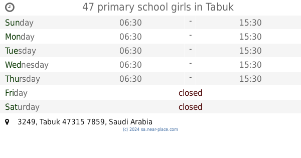
47 primary school girls
3249, Tabuk
School
read more
900 m
المدرسه المتوسطه بنات
مروج الأمير, Tabuk
School
read more
909 m
Thirty-Second Intermediate Girls
7896, 3128, Tabuk
School
read more
912 m
Girls Preparatory School
7896, Tabuk
School
read more
955 m
الثانوية العشرون
7926, Tabuk
School
read more
984 m
مدارس رياض الصالحين للبنات
3923, Tabuk
School
read more
992 m
لبيد بن ربيعة حي مروج الامير
2765, Tabuk
School
read more
1.005 km
Labied Bin Rabeiah
2765, Tabuk
School
read more
1.12 km
مركز صوت الفجر لذوي الاعاقه
Tabuk
School
read more
1.16 km
Osama bin Zaid
Amr Ibn Al As, Tabuk
School
read more
1.188 km
Civil Dar Opinion Schools
Abi Bakr As Siddiq, Tabuk
School
read more
1.213 km
مدارسة دار الرأي الأهليه الثنويه
3751, Tabuk
School
read more
📑
all categories
Accounting
Administrative area level 1
Airport
Amusement park
Aquarium
Art gallery
Atm
Bakery
Bank
Bar
Beauty salon
Bicycle store
Book store
Bowling alley
Bus station
Cafe
Campground
Car dealer
Car rental
Car repair
Car wash
Casino
Cemetery
Church
City hall
Clothing store
Colloquial area
Convenience store
Country
Courthouse
Dentist
Department store
Doctor
Electrician
Electronics store
Embassy
Finance
Fire station
Florist
Food
Funeral home
Furniture store
Gas station
General contractor
Grocery or supermarket
Gym
Hair care
Hardware store
Health
Hindu Temple
Home goods store
Hospital
Insurance agency
Intersection
Jewelry store
Laundry
Lawyer
Library
Light rail station
Liquor store
Local government office
Locality
Locksmith
Lodging
Meal delivery
Meal takeaway
Mosque
Movie rental
Movie theater
Moving company
Museum
Natural feature
Neighborhood
Night club
Painter
Park
Parking
Pet store
Pharmacy
Physiotherapist
Place of worship
Plumber
Point of interest
Police
Political
Post office
Premise
Real estate agency
Restaurant
Roofing contractor
Route
Rv park, camping
School
Shoe store
Shopping mall
Spa
Stadium
Storage
Store
Sublocality
Subpremise
Subway station
Supermarket
Taxi stand
Train station
Transit station
Travel agency
University
Veterinary care
Zoo
sublocality level 1
↑