School nearby روضة القطيف الثانية
Saudi Arabia
School nearby روضة القطيف الثانية
روضة القطيف الثانية
Anak Saudi Arabia
contacts phone
:
+966
Latitude:
26.571855
, Longitude:
50.049538
read more
nearest School
69 m
أبتدائيه تحفيظ القران في القطيف
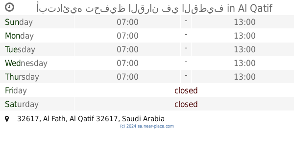
32617, Al Qatif
School
read more
86 m
مدرسة تحفيظ القران الكريم الابتدائيه بالقطيف
32617, Al Qatif
School
read more
158 m
Jareer Elementary School
4 (A) Street, Al Qatif
School
read more
190 m
ملعب ثانوية النجاح
Al Qatif
School
read more
219 m
Al Najah Secondary School
4559 7 (A) Street, Al Qatif
School
read more
233 m
التربية الخاصة بالقطيف
7443 Al Ghayth, Al Qatif
School
read more
240 m
Thabit ibn Qais Primary School
6 Street, Al Qatif
School
read more
340 m
مركز نفائس لرعاية الطفولة
5050, Tarout
School
read more
349 m
مكتبة
Abu Thar Alghifari Street, Tarout
School
read more
416 m
روضة الأنوار1
5 (B) Street, Al Qatif
School
read more
461 m
مركز روعة التغيير للتدريب النسائي
4 Street, Tarout
School
read more
469 m
مركز رونق للدورات التدريبية
4 Street, Tarout
School
read more
484 m
روضة و حضانة جنة الزهراء
شارع جرير بن أوس،, Tarout
School
read more
486 m
Ninth elementary school for girls
Al Qatif
School
read more
506 m
مدرسة بنات
Al Qatif
School
read more
544 m
مدرسة الفخر الرازي المتوسطة
4629 5ب, Al Qatif
School
read more
547 m
Fakhruddin Razi Middle School
5 (B) Street, Al Qatif
School
read more
549 m
ملعب مدرسة الفخر الرازي
Al Qatif
School
read more
597 m
ملعب مدرسة أبي الدرداء
Al Qatif
School
read more
606 m
Abu Darda Elementary School
4635 بلال بن الحارث, Al Qatif
School
read more
623 m
الروضة الرابعة بالقطيف
Al Qatif
School
read more
638 m
الابتدائية الاثنان والعشرون للبنات
Al Qatif
School
read more
648 m
Mohadia Gumbay
Al Fath, Al Hofuf
School
read more
677 m
المتوسطة السادسة بالقطيف
Abu Thar Alghifari Street, Al Qatif
School
read more
679 m
الثانوية الأولى بالقديح-السابعة بالقطيف
Al Qatif
School
read more
📑
all categories
Accounting
Administrative area level 1
Airport
Amusement park
Aquarium
Art gallery
Atm
Bakery
Bank
Bar
Beauty salon
Bicycle store
Book store
Bowling alley
Bus station
Cafe
Campground
Car dealer
Car rental
Car repair
Car wash
Casino
Cemetery
Church
City hall
Clothing store
Colloquial area
Convenience store
Country
Courthouse
Dentist
Department store
Doctor
Electrician
Electronics store
Embassy
Finance
Fire station
Florist
Food
Funeral home
Furniture store
Gas station
General contractor
Grocery or supermarket
Gym
Hair care
Hardware store
Health
Hindu Temple
Home goods store
Hospital
Insurance agency
Intersection
Jewelry store
Laundry
Lawyer
Library
Light rail station
Liquor store
Local government office
Locality
Locksmith
Lodging
Meal delivery
Meal takeaway
Mosque
Movie rental
Movie theater
Moving company
Museum
Natural feature
Neighborhood
Night club
Painter
Park
Parking
Pet store
Pharmacy
Physiotherapist
Place of worship
Plumber
Point of interest
Police
Political
Post office
Premise
Real estate agency
Restaurant
Roofing contractor
Route
Rv park, camping
School
Shoe store
Shopping mall
Spa
Stadium
Storage
Store
Sublocality
Subpremise
Subway station
Supermarket
Taxi stand
Train station
Transit station
Travel agency
University
Veterinary care
Zoo
sublocality level 1
↑