School nearby رياحين الطفولة
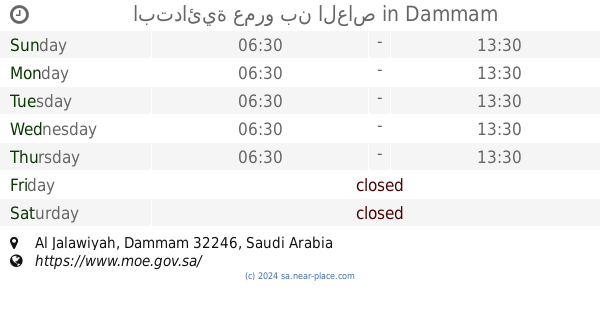
Saudi Arabia
School nearby رياحين الطفولة
رياحين الطفولة
6225, سعيد بن مبارك, 32426, Dammam, SA Saudi Arabia
contacts phone
:
+966
Latitude:
26.4430694
, Longitude:
50.0758392
larger map & directions
read more
nearest School
60 m
مركز رياحين الطفولة
3391 Ibn Asaker, Dammam
School
read more
340 m
Forty primary school for girls
Ibn Al Muzafar, Dammam
School
read more
341 m
روضة اطفال
4535 12 ا, Dammam
School
read more
359 m
Ninth middle school for girls
Ibn Al Muzafar, Dammam
School
read more
361 m
الابتدائية الثامنة والثلاثون
3458, 32426, Dammam
School
read more
376 m
المدرسة الابتدائية الاربعون بالدمام
4495 Ibn Al Muzafar, Dammam
School
read more
403 m
Kindergarten eighth in Dammam
3109 الاوزاعي, Dammam
School
read more
405 m
المدرسةالثانوية الخامسة والعشرون للبنات بالدمام
3120 الاوزاعي, 6539, Dammam
School
read more
422 m
روضة الحوراء
3013 11 ج, Dammam
School
read more
478 m
المدرسة المتوسطة الحادية والثلاثون بالدمام
Dammam
School
read more
482 m
Medium School Girls
Dammam
School
read more
507 m
الابتدائية التاسعة والثلاثون بالدمام (3m)
حي, Dammam
School
read more
549 m
مركز نور
6727 8ج, Dammam
School
read more
623 m
ابتدائية عمرو بن العاص
Dammam
School
read more
691 m
مدارس الديار الاهلية
Prince Abdulmohsin Bin Jlawy Street, Dammam
School
read more
714 m
مدرسه الجلويه
Dammam
School
read more
715 m
مدرسة الجلوية الإبتدائية
8915 احمد السلمي، الدمام
School
read more
741 m
AlEdrissi intermediate School
Prince Abdullah Bin Jalawy Street, Dammam
School
read more
757 m
مركز التعليم الالكتروني بمدرسة الادريسي
الدمام
School
read more
771 m
iCandle 103
3817 الملك سعود, Dammam
School
read more
810 m
Miqdad ibn Amr Primary School
Dammam
School
read more
829 m
الابتدائية الثالثة والعشرون للبنات
5074 5 ا, 9008, Dammam
School
read more
860 m
Miqdad ibn Amr Elementary School
Dammam
School
read more
880 m
مجموعات المتفوقين أميرة
9242 22 ا, Dammam
School
read more
936 m
Al Arabia SS3
King Abdulaziz Street, Dammam
School
read more
📑
all categories
Accounting
Administrative area level 1
Airport
Amusement park
Aquarium
Art gallery
Atm
Bakery
Bank
Bar
Beauty salon
Bicycle store
Book store
Bowling alley
Bus station
Cafe
Campground
Car dealer
Car rental
Car repair
Car wash
Casino
Cemetery
Church
City hall
Clothing store
Colloquial area
Convenience store
Country
Courthouse
Dentist
Department store
Doctor
Electrician
Electronics store
Embassy
Finance
Fire station
Florist
Food
Funeral home
Furniture store
Gas station
General contractor
Grocery or supermarket
Gym
Hair care
Hardware store
Health
Hindu Temple
Home goods store
Hospital
Insurance agency
Intersection
Jewelry store
Laundry
Lawyer
Library
Light rail station
Liquor store
Local government office
Locality
Locksmith
Lodging
Meal delivery
Meal takeaway
Mosque
Movie rental
Movie theater
Moving company
Museum
Natural feature
Neighborhood
Night club
Painter
Park
Parking
Pet store
Pharmacy
Physiotherapist
Place of worship
Plumber
Point of interest
Police
Political
Post office
Premise
Real estate agency
Restaurant
Roofing contractor
Route
Rv park, camping
School
Shoe store
Shopping mall
Spa
Stadium
Storage
Store
Sublocality
Subpremise
Subway station
Supermarket
Taxi stand
Train station
Transit station
Travel agency
University
Veterinary care
Zoo
sublocality level 1
↑