Atm nearby Al-Jazerah Bank
Saudi Arabia
Atm nearby Al-Jazerah Bank
Al-Jazerah Bank
Al Sahil, Al Khobar 34611, Saudi Arabia
contacts phone
:
+966
Latitude:
26.2694319
, Longitude:
50.216177
larger map & directions
read more
nearest Atm
266 m
SABB
LuLu MKT Al Khobar
Atm
read more
278 m
Al Rajhi ATM
2634 Prince Turkey Street, 34611, Al Khobar
Atm
read more
338 m
Al-Bilad
7158 King Fahd Road, 5706, Al Khobar
Atm
read more
396 m
كتوب لتحصيل الديون
King Fahd Road King Fahd Road, Al Khobar
Atm
read more
481 m
SABB ATM
7432-7442 King Fahd Road, Al Khobar
Atm
read more
559 m
ATM machine Automated Riyad Bank
طريق الملك فهد King Fahd Road, Al Khobar
Atm
read more
593 m
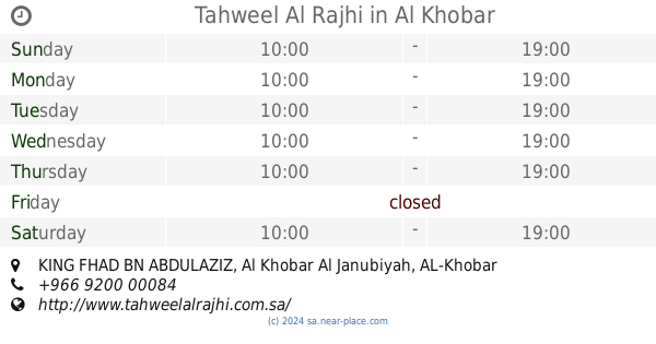
Tahweel Al Rajhi
KING FHAD BN ABDULAZIZ, AL-Khobar AL-Janoubiyah, Al Khobar
Atm
read more
735 m
ATM Saudi Investment Bank
الجبيل Jubail Street, Al Khobar
Atm
read more
845 m
NCB ATM
8697 King Fahd Road, Al Khobar
Atm
read more
876 m
Riyad Bank
Khobar Street, Al Khobar
Atm
read more
959 m
Arab National Bank
Al Mubarraz Street, Al Khobar
Atm
read more
989 m
Bank Al Bilad ATM
25th St 25th Street, Al Khobar
Atm
read more
1.007 km
SABB
Passport ATM Room, Al Khobar
Atm
read more
1.019 km
SABB
Khobar South Road Raka
Atm
read more
1.026 km
ATM SAAB
2611, Al Khobar
Atm
read more
1.043 km
NCB ATM
Khobar Street, Al Khobar
Atm
read more
1.162 km
الأهلي كويك باي
Al Khobar
Atm
read more
1.209 km
صرافة بنك الرياض
Al Khobar
Atm
read more
1.22 km
SABB
Al Rahmaniah Mini G. Floor, Al Khobar
Atm
read more
1.22 km
SABB
Al Rahmaniah Mini 1st Floor, Al Khobar
Atm
read more
1.221 km
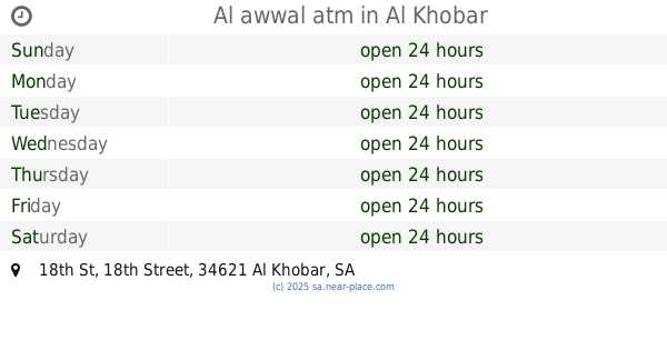
Al awwal atm
18th St 18th Street, Al Khobar
Atm
read more
1.225 km
العربي
3202 الملك فيصل, Al Khobar
Atm
read more
1.23 km
ساب
3202 King Faisal, Al Khobar
Atm
read more
1.23 km
ساب
Prince Talal Street, Al Khobar
Atm
read more
1.249 km
Al Bilad Bank ATM
Custodian of The Two Holy Mosques Rd Custodian of The Two Holy Mosques Road, Al Khobar
Atm
read more
📑
all categories
Accounting
Administrative area level 1
Airport
Amusement park
Aquarium
Art gallery
Atm
Bakery
Bank
Bar
Beauty salon
Bicycle store
Book store
Bowling alley
Bus station
Cafe
Campground
Car dealer
Car rental
Car repair
Car wash
Casino
Cemetery
Church
City hall
Clothing store
Colloquial area
Convenience store
Country
Courthouse
Dentist
Department store
Doctor
Electrician
Electronics store
Embassy
Finance
Fire station
Florist
Food
Funeral home
Furniture store
Gas station
General contractor
Grocery or supermarket
Gym
Hair care
Hardware store
Health
Hindu Temple
Home goods store
Hospital
Insurance agency
Intersection
Jewelry store
Laundry
Lawyer
Library
Light rail station
Liquor store
Local government office
Locality
Locksmith
Lodging
Meal delivery
Meal takeaway
Mosque
Movie rental
Movie theater
Moving company
Museum
Natural feature
Neighborhood
Night club
Painter
Park
Parking
Pet store
Pharmacy
Physiotherapist
Place of worship
Plumber
Point of interest
Police
Political
Post office
Premise
Real estate agency
Restaurant
Roofing contractor
Route
Rv park, camping
School
Shoe store
Shopping mall
Spa
Stadium
Storage
Store
Sublocality
Subpremise
Subway station
Supermarket
Taxi stand
Train station
Transit station
Travel agency
University
Veterinary care
Zoo
sublocality level 1
↑