Atm nearby Alawwal Bank
Coronavirus disease (COVID-19) Situation
confirmed cases
841469
deaths
9646
Saudi Arabia
Atm nearby Alawwal Bank
Alawwal Bank
Al Aqrabiyah, Al Khobar 34445, Saudi Arabia
contacts phone
:
+966 9200 13323
website:
www.alawwalbank.com
Latitude:
26.2980093
, Longitude:
50.1883175
larger map & directions
read more
nearest Atm
195 m
SABB
King Fahd Hospital St, Al Khobar
Atm
read more
274 m
صراف بنك الرياض
الشارع الثاني والعشرون 22nd Street, Al Khobar
Atm
read more
402 m
Arab National Bank
Makkah Al Mukarramah Street, Al Khobar
Atm
read more
409 m
First Bank
Al Khobar
Atm
read more
488 m
صراف بنك الرياض
3295 22nd Street, Al Khobar
Atm
read more
512 m
صراف بنك ساب
Abrar Street, Al Khobar
Atm
read more
523 m
ساب
Dhahran
Atm
read more
523 m
SABB
Al Agrabiah 22nd Street TTW Lobby
Atm
read more
557 m
Alinma ATM
22nd Street, Al Khobar
Atm
read more
702 m
SABB
Consumer Oasis, Al Khobar
Atm
read more
826 m
Bank AlJazira ATM
6892 Makkah Al Mukarramah Street, Al Khobar
Atm
read more
881 m
صراف البنك الأهلي
Al Khobar
Atm
read more
883 m
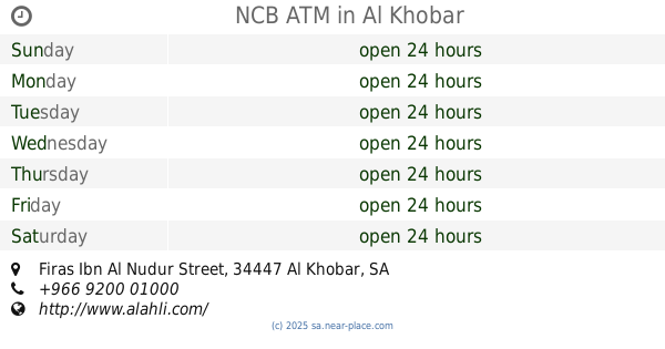
NCB ATM
Firas Ibn Al Nudur Street, Al Khobar
Atm
read more
887 m
صرافة البنك السعودي للاستثمار
16th Street, Al Khobar
Atm
read more
902 m
SABB
Carrefour, Al Rashid Mall, Al Khobar
Atm
read more
942 m
الراجحي
مجمع الراشد, شارع فارس بن نضر ، حي العبقرية, Al Khobar
Atm
read more
948 m
الاهلي
Al Kubar, ش22, Khamis Mushait
Atm
read more
1.059 km
SABB
AGR Branch CDM#1, Al Khobar
Atm
read more
1.062 km
SABB
2, Al Rashed Mall, Al Khobar
Atm
read more
1.062 km
SABB
Al-Rashid Mall, Resturant Floor, Al Khobar
Atm
read more
1.07 km
Riyad Bank ATM
Al Khobar
Atm
read more
1.09 km
صراف البنك الاول
Alshihab Altaifi Street, Al Khobar
Atm
read more
1.094 km
SABB
Agrabia Lobby
Atm
read more
1.096 km
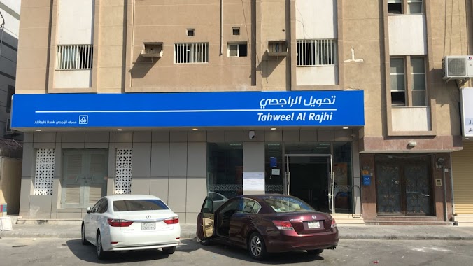
Tahweel Al Rajhi
10th, Al-Aqrabiah, Al Khobar
Atm
read more
1.099 km
Riyad Bank
مجمع الراشد, شارع فارس بن نضر, Al Khobar
Atm
read more
📑
all categories
Accounting
Administrative area level 1
Airport
Amusement park
Aquarium
Art gallery
Atm
Bakery
Bank
Bar
Beauty salon
Bicycle store
Book store
Bowling alley
Bus station
Cafe
Campground
Car dealer
Car rental
Car repair
Car wash
Casino
Cemetery
Church
City hall
Clothing store
Colloquial area
Convenience store
Country
Courthouse
Dentist
Department store
Doctor
Electrician
Electronics store
Embassy
Finance
Fire station
Florist
Food
Funeral home
Furniture store
Gas station
General contractor
Grocery or supermarket
Gym
Hair care
Hardware store
Health
Hindu Temple
Home goods store
Hospital
Insurance agency
Intersection
Jewelry store
Laundry
Lawyer
Library
Light rail station
Liquor store
Local government office
Locality
Locksmith
Lodging
Meal delivery
Meal takeaway
Mosque
Movie rental
Movie theater
Moving company
Museum
Natural feature
Neighborhood
Night club
Painter
Park
Parking
Pet store
Pharmacy
Physiotherapist
Place of worship
Plumber
Point of interest
Police
Political
Post office
Premise
Real estate agency
Restaurant
Roofing contractor
Route
Rv park, camping
School
Shoe store
Shopping mall
Spa
Stadium
Storage
Store
Sublocality
Subpremise
Subway station
Supermarket
Taxi stand
Train station
Transit station
Travel agency
University
Veterinary care
Zoo
sublocality level 1
↑