Atm nearby Alinma ATM
Saudi Arabia
Atm nearby Alinma ATM
Alinma ATM
Abdullah Ibn Umar, Riyadh Saudi Arabia
contacts phone
:
+966
Latitude:
24.7181542
, Longitude:
46.838488
read more
nearest Atm
203 m
بنك الرياض
شارع ابي الأسود الدؤلي حي النسيم الشرقي، الرياض
Atm
read more
203 m
صراف الرياض
شارع ابي الأسود الدؤلي حي النسيم الشرقي، الرياض
Atm
read more
495 m
صراف العربي
شارع حسان بن ثابت، حي النسيم، الرياض
Atm
read more
495 m
بنك العربي
شارع حسان بن ثابت، حي النسيم، الرياض
Atm
read more
510 m
ANB صراف البنك العربي
Usamah Ibn Zaid Usamah Ibn Zaid, Riyadh
Atm
read more
535 m
بنك الرياض
شارع حسان بن ثابت، حي النسيم، الرياض
Atm
read more
535 m
Riyad Bank
شارع حسان بن ثابت، حي النسيم، الرياض
Atm
read more
579 m
مصرف الراجحي
شارع حسان بن ثابت، الرياض
Atm
read more
610 m
مصرف الراجحي
4541 Asim Ibn Umar, Riyadh
Atm
read more
630 m
ATM Riyadh
اسامة بن زيد Usamah Ibn Zaid, 7081-, Riyadh
Atm
read more
652 m
Majeed
7394 An Nawrah, 3773, Riyadh
Atm
read more
741 m
Al Awwal Bank ATM
Hassan Ibn Thabit, Riyadh
Atm
read more
751 m
صراف الراجحي
عبدالله بن عمر Abdullah Ibn Umar, Riyadh
Atm
read more
794 m
AlAhli ATM
6373 حسان بن ثابت، النسيم الشرقي الرياض 14245 3617 Hassan Ibn Thabit, Riyadh
Atm
read more
948 m
alawwal ATM
طريق الأمير سعد بن عبدالرحمن الأول Prince Saad Ibn Abdulrahman Al Awal Road, Riyadh
Atm
read more
970 m
MOI ABSHER DEVICE
Riyadh
Atm
read more
1.017 km
ATM Riyadh
Al Qabah, Riyadh
Atm
read more
1.087 km
Alinma ATM
7244 Abi Hurairah, 3651, Riyadh
Atm
read more
1.099 km
بنك الجزيرة
6784 Saad Ibn Abi Waqas, Riyadh
Atm
read more
1.115 km
Al Rajhi ATM
7434 Saad Ibn Abi Waqas, Riyadh
Atm
read more
1.122 km
Alinma ATM
7567 Saad Ibn Abi Waqas, 3287, Riyadh
Atm
read more
1.124 km
بنك البلاد
Prince Saad Ibn Abdulrahman Al Awal Branch Road, Riyadh
Atm
read more
1.124 km
صراف البلاد
Prince Saad Ibn Abdulrahman Al Awal Branch Road, Riyadh
Atm
read more
1.125 km
بنك البلاد
Usamah Ibn Zaid, Riyadh
Atm
read more
1.131 km
NCB ATM
Usamah Ibn Zaid, Riyadh
Atm
read more
📑
all categories
Accounting
Administrative area level 1
Airport
Amusement park
Aquarium
Art gallery
Atm
Bakery
Bank
Bar
Beauty salon
Bicycle store
Book store
Bowling alley
Bus station
Cafe
Campground
Car dealer
Car rental
Car repair
Car wash
Casino
Cemetery
Church
City hall
Clothing store
Colloquial area
Convenience store
Country
Courthouse
Dentist
Department store
Doctor
Electrician
Electronics store
Embassy
Finance
Fire station
Florist
Food
Funeral home
Furniture store
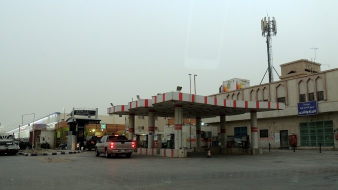
Gas station
General contractor
Grocery or supermarket
Gym
Hair care
Hardware store
Health
Hindu Temple
Home goods store
Hospital
Insurance agency
Intersection
Jewelry store
Laundry
Lawyer
Library
Light rail station
Liquor store
Local government office
Locality
Locksmith
Lodging
Meal delivery
Meal takeaway
Mosque
Movie rental
Movie theater
Moving company
Museum
Natural feature
Neighborhood
Night club
Painter
Park
Parking
Pet store
Pharmacy
Physiotherapist
Place of worship
Plumber
Point of interest
Police
Political
Post office
Premise
Real estate agency
Restaurant
Roofing contractor
Route
Rv park, camping
School
Shoe store
Shopping mall
Spa
Stadium
Storage
Store
Sublocality
Subpremise
Subway station
Supermarket
Taxi stand
Train station
Transit station
Travel agency
University
Veterinary care
Zoo
sublocality level 1
↑