Atm nearby AlJazira ATM
Coronavirus disease (COVID-19) Situation
confirmed cases
841469
deaths
9646
Saudi Arabia
Atm nearby AlJazira ATM
AlJazira ATM
An Nadhim, Riyadh 14813, Saudi Arabia
contacts phone
:
+966
Latitude:
24.7928678
, Longitude:
46.8692264
larger map & directions
read more
nearest Atm
377 m
صراف الراجحي
3158 Al Harith Ibn Abdullah, Riyadh
Atm
read more
377 m
صراف بنك الراجحي
3158 Al Harith Ibn Abdullah, Riyadh
Atm
read more
508 m
البنك الاول ATM
7507 Khurais Road, 2309,, Riyadh
Atm
read more
525 m
ATM Ahli Bank
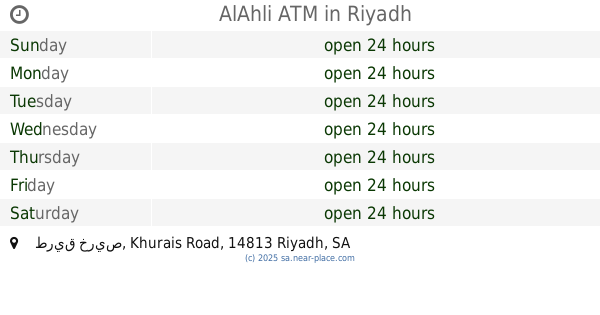
طريق خريص Khurais Road, Riyadh
Atm
read more
535 m
AlAhli ATM
طريق خريص Khurais Road, Riyadh
Atm
read more
538 m
البنك الاهلي
طريق خريص Khurais Road, Riyadh
Atm
read more
580 m
صراف البنك الاول
Khurais Road, Riyadh
Atm
read more
677 m
alinma ATM
7169 Khurais Road, Riyadh
Atm
read more
679 m
Alinma ATM
7195 Khurais Road, 7195 Khurais Rd, 2104, Riyadh
Atm
read more
802 m
alinma ATM
7734 Al Jazirah Al Khadra, Riyadh
Atm
read more
906 m
صراف بنك الاهلي
حي الندوة النظيم،, Riyadh
Atm
read more
932 m
NCB AlAhli Bank ATM
Al Harith Ibn Abdullah, Riyadh
Atm
read more
977 m
SABB
Al Nadwa District (37-198113, Riyadh
Atm
read more
1.374 km
Alinma ATM
Ash Shaikh Khalifa Ibn Hamad Althani Road, Riyadh
Atm
read more
1.395 km
صراف بنك الاهلي
Riyadh
Atm
read more
1.399 km
Al Rajhi ATM
Al Janadriyah Road, Riyadh
Atm
read more
1.424 km
AlJazira ATM
An Nadwah, Riyadh
Atm
read more
1.428 km
anb ATM
Ash Shaikh Khalifa Ibn Hamad Althani Road, Riyadh
Atm
read more
1.437 km
BANK ALJAZIRA ATM
Ar Rayah, Riyadh
Atm
read more
1.504 km
Alinma ATM
الشيخ عبدالعزيز الفوزان, Riyadh
Atm
read more
1.504 km
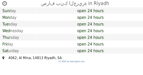
صراف بنك الجزيرة
4062 Al Mina, Riyadh
Atm
read more
1.569 km
Al Rajhi ATM
157 An Nadwah, Riyadh
Atm
read more
1.594 km
صراف بنك الرياض
3489 شقراء, Riyadh
Atm
read more
1.598 km
BANK ALJAZIRA ATM
157 An Nadwah, Riyadh
Atm
read more
1.599 km
AlJazira ATM
157 An Nadwah, Riyadh
Atm
read more
📑
all categories
Accounting
Administrative area level 1
Airport
Amusement park
Aquarium
Art gallery
Atm
Bakery
Bank
Bar
Beauty salon
Bicycle store
Book store
Bowling alley
Bus station
Cafe
Campground
Car dealer
Car rental
Car repair
Car wash
Casino
Cemetery
Church
City hall
Clothing store
Colloquial area
Convenience store
Country
Courthouse
Dentist
Department store
Doctor
Electrician
Electronics store
Embassy
Finance
Fire station
Florist
Food
Funeral home
Furniture store
Gas station
General contractor
Grocery or supermarket
Gym
Hair care
Hardware store
Health
Hindu Temple
Home goods store
Hospital
Insurance agency
Intersection
Jewelry store
Laundry
Lawyer
Library
Light rail station
Liquor store
Local government office
Locality
Locksmith
Lodging
Meal delivery
Meal takeaway
Mosque
Movie rental
Movie theater
Moving company
Museum
Natural feature
Neighborhood
Night club
Painter
Park
Parking
Pet store
Pharmacy
Physiotherapist
Place of worship
Plumber
Point of interest
Police
Political
Post office
Premise
Real estate agency
Restaurant
Roofing contractor
Route
Rv park, camping
School
Shoe store
Shopping mall
Spa
Stadium
Storage
Store
Sublocality
Subpremise
Subway station
Supermarket
Taxi stand
Train station
Transit station
Travel agency
University
Veterinary care
Zoo
sublocality level 1
↑