Atm nearby ATM Al Rajhi🏧
Saudi Arabia
Atm nearby ATM Al Rajhi🏧
ATM Al Rajhi🏧
Riyadh 13797, Saudi Arabia
contacts phone
:
+966 9200 03344
website:
www.alrajhibank.com.sa
Latitude:
24.5248682
, Longitude:
46.4333001
larger map & directions
read more
nearest Atm
6.029 km
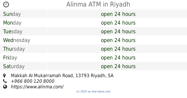
Alinma ATM
Makkah Al Mukarramah Road, Riyadh
Atm
read more
6.743 km
مصرف الإنماء
البديعة
Atm
read more
8.474 km
ANB ATM
الرياض
Atm
read more
9.88 km
SABB
Basateen Alzaad supermarket (38-432770, Riyadh
Atm
read more
10.125 km
صراف البلاد
Najm Ad Din Al Ayyubi, Riyadh
Atm
read more
10.604 km
NCB ATM
Makkah Al Mukarramah Road, Riyadh
Atm
read more
10.803 km
صرافة الرياض
Riyadh
Atm
read more
11.051 km
صراف الراجحي ATM
Taif Street, Riyadh
Atm
read more
11.123 km
مصرف الراجحي ATM
4303 Bilal Ibn Rabah, Riyadh
Atm
read more
11.128 km
ATM
4303 Bilal Ibn Rabah, Riyadh
Atm
read more
11.313 km
صراف البنك الاول
Bilal Ibn Rabah, Riyadh
Atm
read more
11.383 km
Albilad ATM
محطة اجزالا، طريق مكة المكرمة،, Al Muzahimiyah
Atm
read more
11.519 km
Arab ATM Machine
4527 خديجة بنت خويلد, Riyadh
Atm
read more
11.553 km
صراف بنك البلاد مغلق
Riyadh
Atm
read more
11.702 km
SABB ATM
الطائف Taif, Riyadh
Atm
read more
11.702 km
صراف ساب
3980 Taif, 3958-, Riyadh
Atm
read more
11.705 km
جهاز صراف ساب
Riyadh
Atm
read more
11.743 km
SABB
Janain AL Wastta Supermarket (37-201421, Riyadh
Atm
read more
11.765 km
صراف الي الاهلي
5169 Bilal Ibn Rabah, Riyadh
Atm
read more
11.893 km
ATM Saudi Investment Bank Machine
4855 خديجة بنت خويلد, Riyadh
Atm
read more
11.905 km
NCB ATM
2568 ينبع، ظهرة لبن، الرياض 13787 6593 Yanbu, Riyadh
Atm
read more
11.965 km
SABB
Rokn alazhari supermarket (37-282128, Riyadh
Atm
read more
11.977 km
صراف ساب
Riyadh
Atm
read more
12.005 km
Alinma ATM
2642 Yanbu, Riyadh
Atm
read more
12.021 km
Al Rajhi Bank
الاخلاص Al Ikhlas, Riyadh
Atm
read more
📑
all categories
Accounting
Administrative area level 1
Airport
Amusement park
Aquarium
Art gallery
Atm
Bakery
Bank
Bar
Beauty salon
Bicycle store
Book store
Bowling alley
Bus station
Cafe
Campground
Car dealer
Car rental
Car repair
Car wash
Casino
Cemetery
Church
City hall
Clothing store
Colloquial area
Convenience store
Country
Courthouse
Dentist
Department store
Doctor
Electrician
Electronics store
Embassy
Finance
Fire station
Florist
Food
Funeral home
Furniture store
Gas station
General contractor
Grocery or supermarket
Gym
Hair care
Hardware store
Health
Hindu Temple
Home goods store
Hospital
Insurance agency
Intersection
Jewelry store
Laundry
Lawyer
Library
Light rail station
Liquor store
Local government office
Locality
Locksmith
Lodging
Meal delivery
Meal takeaway
Mosque
Movie rental
Movie theater
Moving company
Museum
Natural feature
Neighborhood
Night club
Painter
Park
Parking
Pet store
Pharmacy
Physiotherapist
Place of worship
Plumber
Point of interest
Police
Political
Post office
Premise
Real estate agency
Restaurant
Roofing contractor
Route
Rv park, camping
School
Shoe store
Shopping mall
Spa
Stadium
Storage
Store
Sublocality
Subpremise
Subway station
Supermarket
Taxi stand
Train station
Transit station
Travel agency
University
Veterinary care
Zoo
sublocality level 1
↑