Atm nearby Bank Albilad ATM
Saudi Arabia
Atm nearby Bank Albilad ATM
Bank Albilad ATM
Al-Ashjar Mall, Abana, Jeddah Saudi Arabia
contacts phone
:
+966
Latitude:
21.4267226
, Longitude:
39.2980957
read more
nearest Atm
25 m
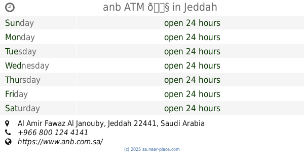
anb ATM 🏧
Jeddah
Atm
read more
91 m
بنك الجزيرة
سيد الشهداء، حي الأمير فواز، جدة
Atm
read more
93 m
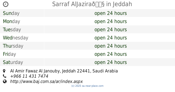
Sarraf AlJazira🏧
Jeddah
Atm
read more
200 m
NCB Atm
Sayed Al-Shuhada'a, Jeddah
Atm
read more
585 m
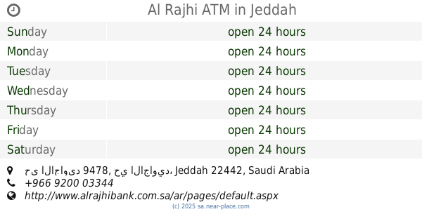
Alrajhi ATM
2521 عبدبن جاسر, Al Amir Fawaz Al Janouby District, Jeddah
Atm
read more
1000 m
Al Rajhi ATM
9492, Al Ajaweed District, Jeddah
Atm
read more
1.164 km
Al Rajhi ATM
3482, حي الاجاويد 9478, Jeddah
Atm
read more
1.251 km
مصرف الراجحي
حي العدل، جدة
Atm
read more
1.252 km
ATM
6427 حي العدل جدة 22361
Atm
read more
1.32 km
صراف بنك الرياض
6513, حي العدل 4296, Jeddah
Atm
read more
1.394 km
صراف البنك الفرنسي
4121 Makkah - Jeddah Highway, حي الاجاويد, Jeddah
Atm
read more
1.439 km
صرافات البنك السعودي الفرنسي
4157 طريق مكة جدة السريع، حي الاجاويد جدة 22441 7403 Makkah - Jeddah Highway, Jeddah
Atm
read more
1.448 km
AlRajhi ATM
Jeddah
Atm
read more
1.762 km
صراف الاهلي
8786, حي الاجاويد، 3985, Jeddah
Atm
read more
1.766 km
Albilad ATM
Jeddah
Atm
read more
1.788 km
مصرف الرياض
8679, Al Ajaweed District, Jeddah
Atm
read more
1.802 km
صراف البنك العربي
3510 Makkah - Jeddah Highway, حي الفضل, Jeddah
Atm
read more
1.815 km
Al Rajhi ATM
3716, حي العدل, Jeddah
Atm
read more
1.914 km
صراف البلاد
Jeddah
Atm
read more
1.978 km
NCB
8510, Al Ajaweed District, Jeddah
Atm
read more
2.088 km
Al Rajhi ATM
8377, حي الاجاويد, Jeddah
Atm
read more
2.102 km
صراف بنك البلاد
8345, حي الاجاويد 3872, Jeddah
Atm
read more
2.129 km
Alawwal Bank ATM
Sayed Al-Shuhada'a, Jeddah
Atm
read more
2.144 km
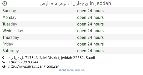
صراف مصرف الراجحي
3051, حي العدل، 7175, Jeddah
Atm
read more
2.147 km
مصرف الراجحي
3051, حي العدل،, Jeddah
Atm
read more
📑
all categories
Accounting
Administrative area level 1
Airport
Amusement park
Aquarium
Art gallery
Atm
Bakery
Bank
Bar
Beauty salon
Bicycle store
Book store
Bowling alley
Bus station
Cafe
Campground
Car dealer
Car rental
Car repair
Car wash
Casino
Cemetery
Church
City hall
Clothing store
Colloquial area
Convenience store
Country
Courthouse
Dentist
Department store
Doctor
Electrician
Electronics store
Embassy
Finance
Fire station
Florist
Food
Funeral home
Furniture store
Gas station
General contractor
Grocery or supermarket
Gym
Hair care
Hardware store
Health
Hindu Temple
Home goods store
Hospital
Insurance agency
Intersection
Jewelry store
Laundry
Lawyer
Library
Light rail station
Liquor store
Local government office
Locality
Locksmith
Lodging
Meal delivery
Meal takeaway
Mosque
Movie rental
Movie theater
Moving company
Museum
Natural feature
Neighborhood
Night club
Painter
Park
Parking
Pet store
Pharmacy
Physiotherapist
Place of worship
Plumber
Point of interest
Police
Political
Post office
Premise
Real estate agency
Restaurant
Roofing contractor
Route
Rv park, camping
School
Shoe store
Shopping mall
Spa
Stadium
Storage
Store
Sublocality
Subpremise
Subway station
Supermarket
Taxi stand
Train station
Transit station
Travel agency
University
Veterinary care
Zoo
sublocality level 1
↑