Atm nearby NCB
Saudi Arabia
Atm nearby NCB
NCB
7503, King Saud Hospital 2721 As Salhiyah District As Salhiyah District, Unayzah Saudi Arabia
contacts phone
:
+966
Latitude:
26.1041045
, Longitude:
43.9909198
read more
nearest Atm
452 m
SABB
Al Salhiya Drive Up, Unayzah
Atm
read more
456 m
ساب
حي الصالحية، عنيزة
Atm
read more
498 m
صراف البنك الأهلي🏧
Unayzah
Atm
read more
560 m
Riyad ATM🏧
Othaim Mall, Unayzah
Atm
read more
561 m
صراف الإنماء
طريق الملك عبدالعزيز، حي المنتزه، عنيزة
Atm
read more
695 m
Al Rajhi ATM
شارع الأمير سلطان بن عبدالعزيز Prince Sultan bin Abdulaziz Street, حي الصالحية, Unayzah
Atm
read more
735 m
AlJazira ATM
26°06'22.4"N 43°59'52.3"E
Atm
read more
793 m
Al Rajhi ATM🏧
7101 Prince Sultan bin Abdulaziz Street, Unayzah
Atm
read more
807 m
ATM Investment Bank🏧
6879 King Abdulaziz Road, حي الصالحية،, Unayzah
Atm
read more
807 m
البنك السعودي للاستثمار
King Abdulaziz Road, Unayzah
Atm
read more
855 m
NCB ATM
Unayzah
Atm
read more
981 m
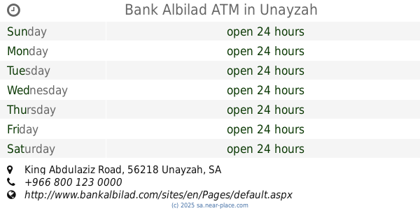
Bank Albilad ATM
King Abdulaziz Road, Unayzah
Atm
read more
1.08 km
Al Rajhi ATM
6513 King Abdulaziz Road, حي الهداء،, Unayzah
Atm
read more
1.089 km
Al Rajhi ATM
6718 King Abdulaziz Road, Unayzah
Atm
read more
1.139 km
صراف البنك الاهلي التجاري
6471 طريق الملك عبدالعزيز، حي الهداء عنيزة 56437 2316 King Abdulaziz Road, Unayzah
Atm
read more
1.155 km
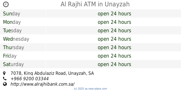
Al Rajhi ATM
7078 King Abdulaziz Road, Unayzah
Atm
read more
1.257 km
Riyad ATM
8441-8475 Prince Sultan bin Abdulaziz Street, Unayzah
Atm
read more
1.349 km
Bank Albilad ATM
Unayzah
Atm
read more
1.353 km
صراف الرياض
Unayzah
Atm
read more
1.359 km
مصرف الإنماء
شارع الشبيلي، عنيزة
Atm
read more
1.365 km
Al-Ahli Bank ATM
شارع هلالة, Unayzah
Atm
read more
1.368 km
صراف الإنماء
شارع الشبيلي، عنيزة
Atm
read more
1.379 km
ATM
Shikhah،عنیزه
Atm
read more
1.387 km
مركبة الفخامة لتأجير السيارات فرع طريق الزلفي
Unayzah
Atm
read more
1.394 km
Bank AlBilad ATM
Ash Shabili, Unayzah
Atm
read more
📑
all categories
Accounting
Administrative area level 1
Airport
Amusement park
Aquarium
Art gallery
Atm
Bakery
Bank
Bar
Beauty salon
Bicycle store
Book store
Bowling alley
Bus station
Cafe
Campground
Car dealer
Car rental
Car repair
Car wash
Casino
Cemetery
Church
City hall
Clothing store
Colloquial area
Convenience store
Country
Courthouse
Dentist
Department store
Doctor
Electrician
Electronics store
Embassy
Finance
Fire station
Florist
Food
Funeral home
Furniture store
Gas station
General contractor
Grocery or supermarket
Gym
Hair care
Hardware store
Health
Hindu Temple
Home goods store
Hospital
Insurance agency
Intersection
Jewelry store
Laundry
Lawyer
Library
Light rail station
Liquor store
Local government office
Locality
Locksmith
Lodging
Meal delivery
Meal takeaway
Mosque
Movie rental
Movie theater
Moving company
Museum
Natural feature
Neighborhood
Night club
Painter
Park
Parking
Pet store
Pharmacy
Physiotherapist
Place of worship
Plumber
Point of interest
Police
Political
Post office
Premise
Real estate agency
Restaurant
Roofing contractor
Route
Rv park, camping
School
Shoe store
Shopping mall
Spa
Stadium
Storage
Store
Sublocality
Subpremise
Subway station
Supermarket
Taxi stand
Train station
Transit station
Travel agency
University
Veterinary care
Zoo
sublocality level 1
↑