Atm nearby NCB ATM
Saudi Arabia
Atm nearby NCB ATM
NCB ATM
8526 Al Sahaba Road, Riyadh Saudi Arabia
contacts phone
:
+966
Latitude:
24.8140631
, Longitude:
46.7760991
read more
nearest Atm
4 m
Atm
8526 طريق الصحابة، اليرموك الرياض 13243
Atm
read more
45 m
الأهلي
8515 Faris, Riyadh
Atm
read more
150 m
صراف الانماء
طريق الدمام الفرعي، حي اليرموك، الرياض
Atm
read more
385 m
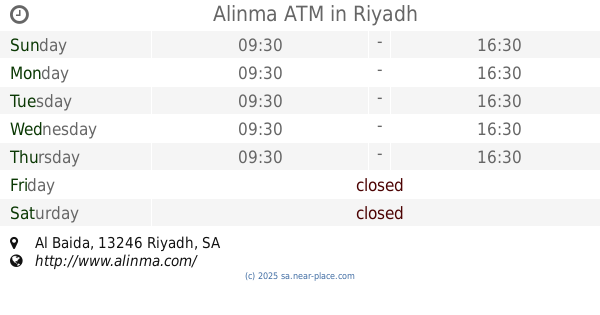
Alinma ATM
Al Sahaba Road, Riyadh
Atm
read more
387 m
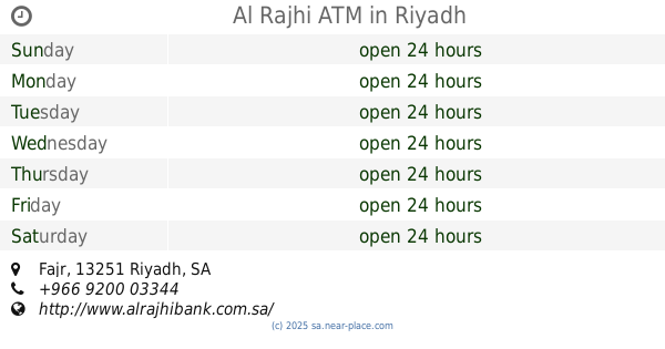
Al Rajhi ATM
Fajr, Riyadh
Atm
read more
440 m
بنك الجزيرة
شارع عسير، حي المونسية، الرياض
Atm
read more
682 m
بنك الجزيرة
Riyadh
Atm
read more
738 m
Alinma ATM
Dammam Branch Road, Riyadh
Atm
read more
754 m
Alahli ATM
Dammam Branch Road, Riyadh
Atm
read more
801 m
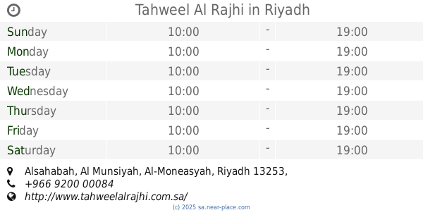
Tahweel Al Rajhi
Alsahabah, Al-Moneasyah, Riyadh
Atm
read more
862 m
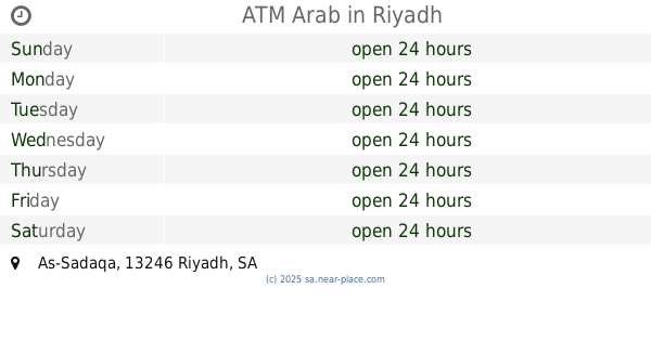
ATM Arab
As-Sadaqa, Riyadh
Atm
read more
864 m
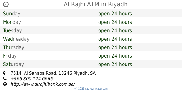
Al Rajhi ATM
7514 Al Sahaba Road, Riyadh
Atm
read more
878 m
ATM Ahli
2999 طريق الدمام الفرعي، اليرموك الرياض 13243 8211 Dammam Branch Road, Riyadh
Atm
read more
897 m
NCB ATM
7942 ابي الفتوح الخباز، اليرموك الرياض 13251 2860 Abi Al Futuh La Khabbaz, Riyadh
Atm
read more
916 m
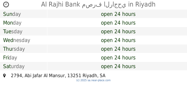
Al Rajhi Bank مصرف الراجحي
2794 Abi Jafar Al Mansur, Riyadh
Atm
read more
930 m
صراف الإنماء
3778 Dammam Road, 6497, Riyadh
Atm
read more
965 m
صراف الجزيرة
Riyadh
Atm
read more
1.008 km
Alinma ATM
Al Baida, Riyadh
Atm
read more
1.009 km
Alinma ATM
7541 Abi Jafar Al Mansur, Riyadh
Atm
read more
1.019 km
ساب
شارع البيضاء، حي المونسية، الرياض
Atm
read more
1.028 km
Alrajhi Bank ATM
7622 الصحابة, Riyadh
Atm
read more
1.039 km
SABB
Al Baida Street TTW (37-62933, Riyadh
Atm
read more
1.094 km
SABB
Al Aqeeq MKT, Dorat, Riyadh
Atm
read more
1.123 km
Alinma ATM
3624 Dammam Road, 6414,, Riyadh
Atm
read more
1.174 km
Riyad ATM
Dammam Road, Riyadh
Atm
read more
📑
all categories
Accounting
Administrative area level 1
Airport
Amusement park
Aquarium
Art gallery
Atm
Bakery
Bank
Bar
Beauty salon
Bicycle store
Book store
Bowling alley
Bus station
Cafe
Campground
Car dealer
Car rental
Car repair
Car wash
Casino
Cemetery
Church
City hall
Clothing store
Colloquial area
Convenience store
Country
Courthouse
Dentist
Department store
Doctor
Electrician
Electronics store
Embassy
Finance
Fire station
Florist
Food
Funeral home
Furniture store
Gas station
General contractor
Grocery or supermarket
Gym
Hair care
Hardware store
Health
Hindu Temple
Home goods store
Hospital
Insurance agency
Intersection
Jewelry store
Laundry
Lawyer
Library
Light rail station
Liquor store
Local government office
Locality
Locksmith
Lodging
Meal delivery
Meal takeaway
Mosque
Movie rental
Movie theater
Moving company
Museum
Natural feature
Neighborhood
Night club
Painter
Park
Parking
Pet store
Pharmacy
Physiotherapist
Place of worship
Plumber
Point of interest
Police
Political
Post office
Premise
Real estate agency
Restaurant
Roofing contractor
Route
Rv park, camping
School
Shoe store
Shopping mall
Spa
Stadium
Storage
Store
Sublocality
Subpremise
Subway station
Supermarket
Taxi stand
Train station
Transit station
Travel agency
University
Veterinary care
Zoo
sublocality level 1
↑