Atm nearby NCB
Saudi Arabia
Atm nearby NCB
NCB
King Fahd University of Petroleum and Minerals, Dhahran 34463, Saudi-Arabien
contacts phone
:
+966 9200 01000
website:
www.alahli.com
Latitude:
26.3141449
, Longitude:
50.1477817
larger map & directions
read more
nearest Atm
44 m
بنك البلاد
Dhahran
Atm
read more
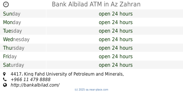
45 m
Bank Albilad ATM
7088, 4417, Dhahran
Atm
read more
448 m
Samba ATM
6935, Dhahran
Atm
read more
895 m
Samba ATM
Dhahran
Atm
read more
928 m
Alawwal bank
Doha Road, Dhahran
Atm
read more
1.161 km
Al Rajhi Bank ATM
Dhahran
Atm
read more
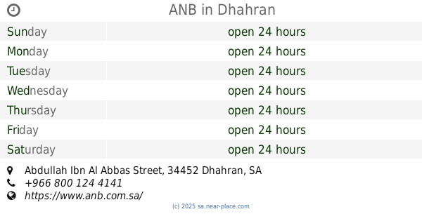
1.175 km
ANB
Medical Access Road No. 1, Dhahran
Atm
read more
1.3 km
SABB
Aramco Hospital Mini ALDHHRAN
Atm
read more
1.516 km
Riyad Bank
King Fahd University of Petroleum and Minerals, Dhahran
Atm
read more
1.616 km
ANB
Abdullah Ibn Al Abbas Street, Dhahran
Atm
read more
1.625 km
Samba ATM
Dhahran Boulevard, Dhahran
Atm
read more
1.671 km
SABB
ARAMCO Tower ALDHHRAN
Atm
read more
1.672 km
National Commercial Bank
Tower Administraion Building, Dhahran
Atm
read more
1.672 km
National Commercial Bank (NCB) ATM
Dhahran
Atm
read more
1.721 km
SABB
Aramco Training Centre
Atm
read more
1.752 km
Banque Saudi Fransi ATM
Unnamed Road, Saudi Aramco, Dhahran
Atm
read more
1.804 km
البنك السعودي الفرنسي
شارع عبد الله بن عباس- حي الدوحة الجنوبية، الظهران
Atm
read more
1.807 km
Alawwal bank
Eastern Avenue, Dhahran
Atm
read more
1.811 km
Samba
Eastern Avenue, Dhahran
Atm
read more
1.852 km
SABB
Eastern Avenue
Atm
read more
1.882 km
SABB
DHH Branch Lobby ALDHHRAN
Atm
read more
1.908 km
Alinma ATM
Dhahran
Atm
read more
1.939 km
SABB
Aramco light branch ATM (351000131153
Atm
read more
1.979 km
SABB
Dammam
Atm
read more
1.988 km
Alawwal Bank ATM
Abdullah Ibn Al Abbas Street, Dhahran
Atm
read more
📑
all categories
Accounting
Administrative area level 1
Airport
Amusement park
Aquarium
Art gallery
Atm
Bakery
Bank
Bar
Beauty salon
Bicycle store
Book store
Bowling alley
Bus station
Cafe
Campground
Car dealer
Car rental
Car repair
Car wash
Casino
Cemetery
Church
City hall
Clothing store
Colloquial area
Convenience store
Country
Courthouse
Dentist
Department store
Doctor
Electrician
Electronics store
Embassy
Finance
Fire station
Florist
Food
Funeral home
Furniture store
Gas station
General contractor
Grocery or supermarket
Gym
Hair care
Hardware store
Health
Hindu Temple
Home goods store
Hospital
Insurance agency
Intersection
Jewelry store
Laundry
Lawyer
Library
Light rail station
Liquor store
Local government office
Locality
Locksmith
Lodging
Meal delivery
Meal takeaway
Mosque
Movie rental
Movie theater
Moving company
Museum
Natural feature
Neighborhood
Night club
Painter
Park
Parking
Pet store
Pharmacy
Physiotherapist
Place of worship
Plumber
Point of interest
Police
Political
Post office
Premise
Real estate agency
Restaurant
Roofing contractor
Route
Rv park, camping
School
Shoe store
Shopping mall
Spa
Stadium
Storage
Store
Sublocality
Subpremise
Subway station
Supermarket
Taxi stand
Train station
Transit station
Travel agency
University
Veterinary care
Zoo
sublocality level 1
↑