Atm nearby SABB
Saudi Arabia
Atm nearby SABB
SABB
Mobily C1, Head Office, Riyadh 12214, Saudi Arabia
contacts phone
:
+966 9200 07222
website:
www.sabb.com
Latitude:
24.708977
, Longitude:
46.675176
larger map & directions
read more
nearest Atm
183 m
سامبا
شارع رقم 94، العليا، الرياض
Atm
read more
220 m
بنك باكستان الوطني
Riyadh
Atm
read more
328 m
najlatarget
Riyadh
Atm
read more
475 m
صرافة البنك الاول
9004 Al Ulaya، الرياض
Atm
read more
481 m
صرافة السعودي الفرنسي
العليا،, Riyadh
Atm
read more
503 m
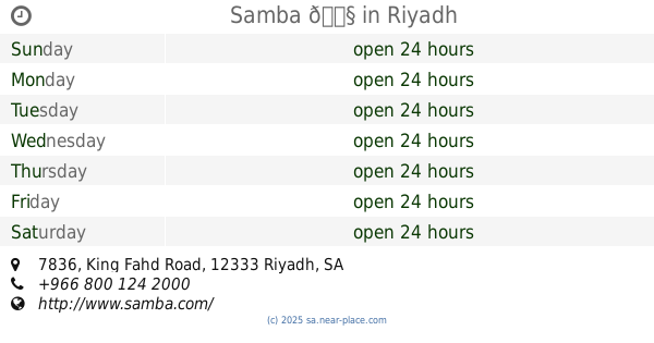
Samba ATM
7836 King Fahd Road, Riyadh
Atm
read more
503 m
Samba 🏧
7836 King Fahd Road, Riyadh
Atm
read more
539 m
Alinma ATM
2868 Al Urubah Road, Riyadh
Atm
read more
553 m
First Bank ATM
2570 شارع رقم 74، العليا، الرياض 12214 8826 Street Number 74, Riyadh
Atm
read more
558 m
Riyadh Bank ATM
Al Olya Mall 2، الرياض
Atm
read more
571 m
ATM
Al Wurud،ریاض
Atm
read more
596 m
SaIB ATM
Riyadh
Atm
read more
621 m
Alinma ATM
6141 King Fahd Branch Rd, Al Wurud, Riyadh 12215 2886 King Fahd Branch Road, Riyadh
Atm
read more
629 m
NCB ATM
Al Urubah Branch Road, Riyadh
Atm
read more
673 m
العربي
طريق العروبة - السليمانية، الرياض
Atm
read more
678 m
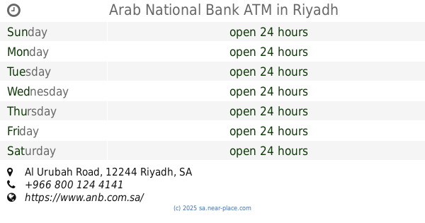
Arab National Bank ATM
Al Urubah Road, Riyadh
Atm
read more
765 m
Al Rajhi ATM
Musa Ibn Nusair Street, Riyadh
Atm
read more
809 m
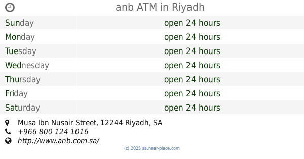
anb ATM
8326 ابن الاثير، الرياض
Atm
read more
809 m
anb ATM
8326 Ibn Al Athir, Riyadh
Atm
read more
822 m
anb ATM
Musa Ibn Nusair Street, 2nd Akaria Mall, Riyadh
Atm
read more
848 m
صراف الرياض
Al Urubah Branch Road, Riyadh
Atm
read more
848 m
Riyad Bank
Al Urubah Branch Road, Riyadh
Atm
read more
1.072 km
صراف الراجحي
3835 Musa Ibn Nusair Street, Riyadh
Atm
read more
1.112 km
Alinma ATM
Al Muhandis Masaid Al Anqari, Riyadh
Atm
read more
1.121 km
ATM Bank Afrenca🏧
Takhassusi Street, Riyadh
Atm
read more
📑
all categories
Accounting
Administrative area level 1
Airport
Amusement park
Aquarium
Art gallery
Atm
Bakery
Bank
Bar
Beauty salon
Bicycle store
Book store
Bowling alley
Bus station
Cafe
Campground
Car dealer
Car rental
Car repair
Car wash
Casino
Cemetery
Church
City hall
Clothing store
Colloquial area
Convenience store
Country
Courthouse
Dentist
Department store
Doctor
Electrician
Electronics store
Embassy
Finance
Fire station
Florist
Food
Funeral home
Furniture store
Gas station
General contractor
Grocery or supermarket
Gym
Hair care
Hardware store
Health
Hindu Temple
Home goods store
Hospital
Insurance agency
Intersection
Jewelry store
Laundry
Lawyer
Library
Light rail station
Liquor store
Local government office
Locality
Locksmith
Lodging
Meal delivery
Meal takeaway
Mosque
Movie rental
Movie theater
Moving company
Museum
Natural feature
Neighborhood
Night club
Painter
Park
Parking
Pet store
Pharmacy
Physiotherapist
Place of worship
Plumber
Point of interest
Police
Political
Post office
Premise
Real estate agency
Restaurant
Roofing contractor
Route
Rv park, camping
School
Shoe store
Shopping mall
Spa
Stadium
Storage
Store
Sublocality
Subpremise
Subway station
Supermarket
Taxi stand
Train station
Transit station
Travel agency
University
Veterinary care
Zoo
sublocality level 1
↑