Atm nearby Samba ATM🏧
Saudi Arabia
Atm nearby Samba ATM🏧
Samba ATM🏧
King Saud Road, Al Kharj Saudi Arabia
contacts phone
:
+966
Latitude:
24.1594678
, Longitude:
47.3162457
read more
nearest Atm
68 m
The Saudi Investment Bank ATM
King Saud Road, Al Kharj
Atm
read more
164 m
SABB
Omar bin khattab Street (37-141080, Al Kharj
Atm
read more
238 m
SABB
Al Kharj
Atm
read more
306 m
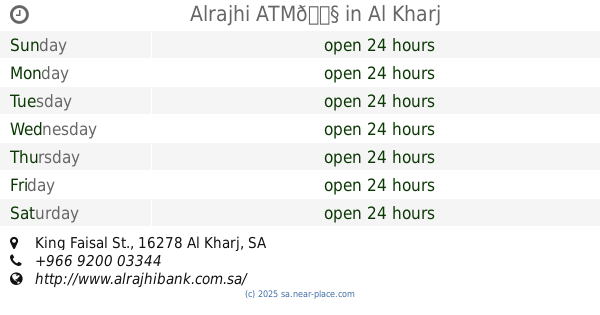
Alrajhi ATM🏧
King Faisal St., Al Kharj
Atm
read more
384 m
Riyad ATM
Najmat Al - Madaen G.S، الخرج
Atm
read more
414 m
Riyad Bank
Prince Naser Bin Abdulaziz Street, Al Kharj
Atm
read more
480 m
Ahli ATM
Al Kharj
Atm
read more
546 m
SABB
Al Ali Drive Up, Al Kharj
Atm
read more
669 m
Alinma ATM
Prince Naser Bin Abdulaziz Street, Al Kharj
Atm
read more
738 m
SABB
KHJ Branch CDM, Al Kharj
Atm
read more
776 m
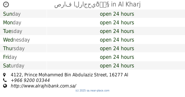
صراف بنك الاهلي🏧
Prince Naser Bin Abdulaziz Street, Al Kharj
Atm
read more
908 m
صراف الراجحي
طريق أبي بكر الصديق،، الخرج
Atm
read more
1.14 km
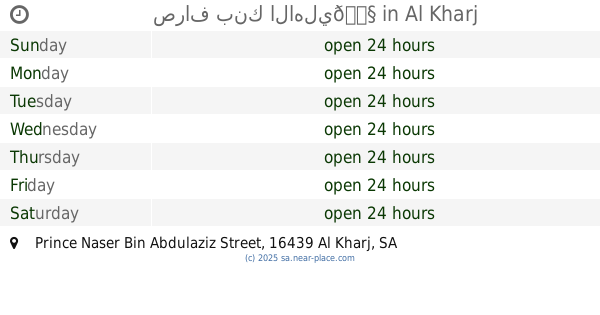
صراف الراجحي🏧
4122 Prince Mohammed Bin Abdulaziz Street, Al Kharj
Atm
read more
1.16 km
Ahli ATM🏧
3888 King Fahd Rd, As Sulaymaniyah Al Kharj 16278 6708 King Fahd Road, Al Kharj
Atm
read more
1.255 km
صراف البنك العربي🏧
3041 King Fahd Road, Al Kharj
Atm
read more
1.291 km
Riyad Bank🏧
Abu Bakr Al Siddiq Road, Al Kharj
Atm
read more
1.507 km
صرافة الراجحي
Othman Ibn Affan Road, Al Kharj
Atm
read more
1.508 km
صراف بنك الرياض
King Abdullah Road, Al Kharj
Atm
read more
1.53 km
Al Rajhi Atm🏧
Al Kharj
Atm
read more
1.542 km
Alinma ATM
Othman Ibn Affan Road, Al Kharj
Atm
read more
1.595 km
صراف البنك الاهلي🏧
King Saud Road, Al Kharj
Atm
read more
1.613 km
Al Rajhi ATM🏧
Yamamah Road, Al Kharj
Atm
read more
1.63 km
ATM Saudi Investment Bank
Al Kharj
Atm
read more
1.673 km
Riyad Bank ATM
King Abdulaziz Road, Al Kharj
Atm
read more
1.715 km
Samba
King Abdulaziz Road, Al Kharj
Atm
read more
📑
all categories
Accounting
Administrative area level 1
Airport
Amusement park
Aquarium
Art gallery
Atm
Bakery
Bank
Bar
Beauty salon
Bicycle store
Book store
Bowling alley
Bus station
Cafe
Campground
Car dealer
Car rental
Car repair
Car wash
Casino
Cemetery
Church
City hall
Clothing store
Colloquial area
Convenience store
Country
Courthouse
Dentist
Department store
Doctor
Electrician
Electronics store
Embassy
Finance
Fire station
Florist
Food
Funeral home
Furniture store
Gas station
General contractor
Grocery or supermarket
Gym
Hair care
Hardware store
Health
Hindu Temple
Home goods store
Hospital
Insurance agency
Intersection
Jewelry store
Laundry
Lawyer
Library
Light rail station
Liquor store
Local government office
Locality
Locksmith
Lodging
Meal delivery
Meal takeaway
Mosque
Movie rental
Movie theater
Moving company
Museum
Natural feature
Neighborhood
Night club
Painter
Park
Parking
Pet store
Pharmacy
Physiotherapist
Place of worship
Plumber
Point of interest
Police
Political
Post office
Premise
Real estate agency
Restaurant
Roofing contractor
Route
Rv park, camping
School
Shoe store
Shopping mall
Spa
Stadium
Storage
Store
Sublocality
Subpremise
Subway station
Supermarket
Taxi stand
Train station
Transit station
Travel agency
University
Veterinary care
Zoo
sublocality level 1
↑