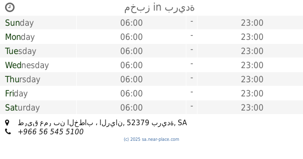
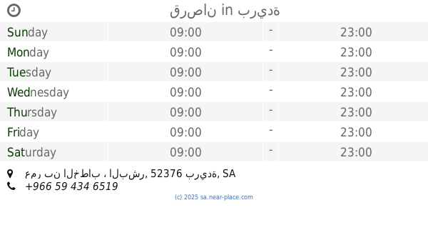
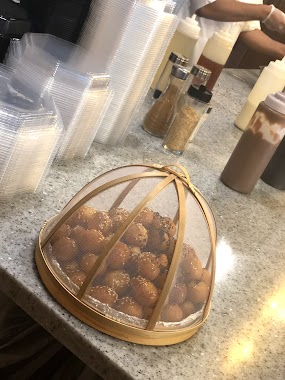
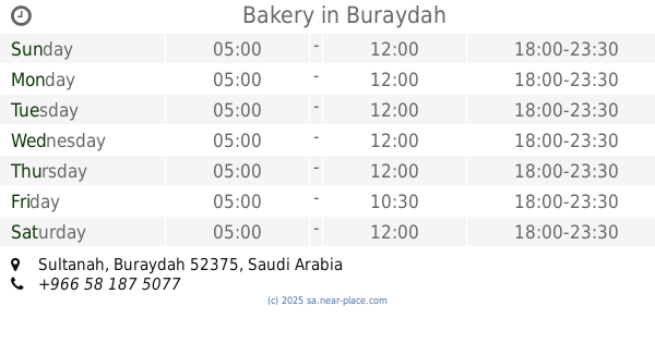
Bakery nearby برزة للفطائر
Coronavirus disease (COVID-19) Situation
confirmed cases
841469
deaths
9646
Saudi Arabia
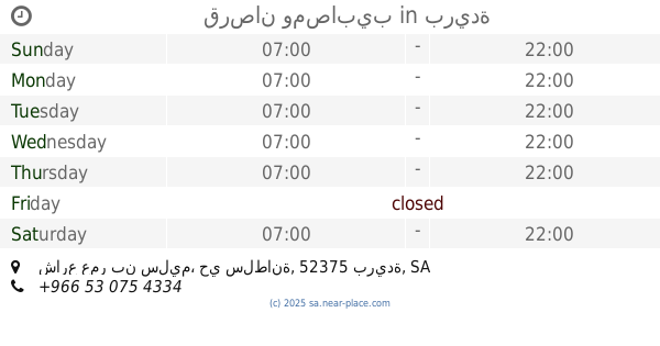
Bakery nearby برزة للفطائر
برزة للفطائر
Alrayan, Buraydah 52379, Saudi-Arabien
contacts phone
:
+966 16 383 3300
Latitude:
26.4057601
, Longitude:
43.9196337
larger map & directions
read more
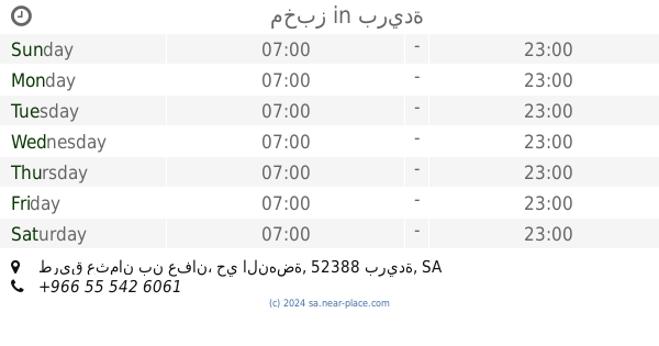
nearest Bakery
273 m
Saffron Sweets
8690 شارع محمد بن سيرين - الريان, Buraydah
Bakery
read more
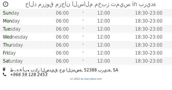
283 m
مخبز
طريق عمر بن الخطاب ، الريان، بريدة
Bakery
read more
560 m
Orveil | أورڤيل
Buraydah
Bakery
read more
592 m
مخابز جليانة
Umar Ibn Al Khatab Rd Umar Ibn Al Khatab Road, Buraydah
Bakery
read more
592 m
مخابز جليانة
Umar Ibn Al Khatab Road, عمر بن الخطاب،, Buraydah
Bakery
read more
653 m
Alaryaf
Buraydah
Bakery
read more
1.001 km
CEMIA
Buraydah
Bakery
read more
1.071 km
مخبز
طريق عثمان بن عفان، حي النهضة، بريدة
Bakery
read more
1.174 km
Queen cake
6381-6415 Umar Ibn Al Khatab Road, Buraydah
Bakery
read more
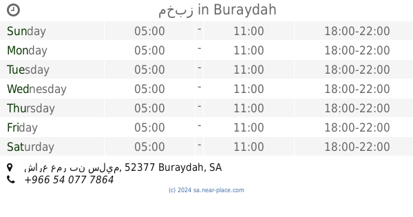
1.609 km
الخباز المحترف
النهضة، بريدة
Bakery
read more
2.017 km
خالد مرزوق مرجان السالم مخبز تميس
طريق أبو بكر الصديق، حي النهضة، بريدة
Bakery
read more
2.413 km
مخبز تميس
Umar Ibn Al Khatab Road, Buraydah
Bakery
read more
2.772 km
مخبز
شارع عمر بن سليم, Buraydah
Bakery
read more
2.791 km
مخبز تميس
Buraydah
Bakery
read more
3.039 km
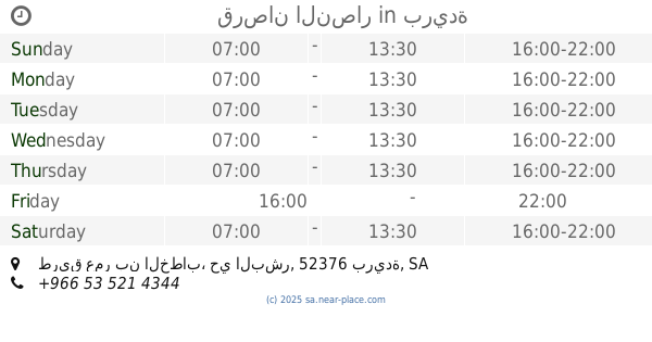
قرصان
عمر بن الخطاب ، البشر، بريدة
Bakery
read more
3.286 km
لقيمات غزلان
Al Iskan, Buraydah
Bakery
read more
3.344 km
Al Aryaf Bakeries and Sweets
Buraydah
Bakery
read more
3.49 km
لينو ايس كريم
طريق الملك خالد،، بريدة
Bakery
read more
3.503 km
سكاكروكيك
طريق عمر بن الخطاب Umar Ibn Al Khatab Road, Buraydah
Bakery
read more
3.678 km
قرصان النصار
طريق عمر بن الخطاب، حي البشر، بريدة
Bakery
read more
3.975 km
قرصان ومصابيب
شارع عمر بن سليم، حي سلطانة، بريدة
Bakery
read more
4.029 km
Bakery
Buraydah
Bakery
read more
4.088 km
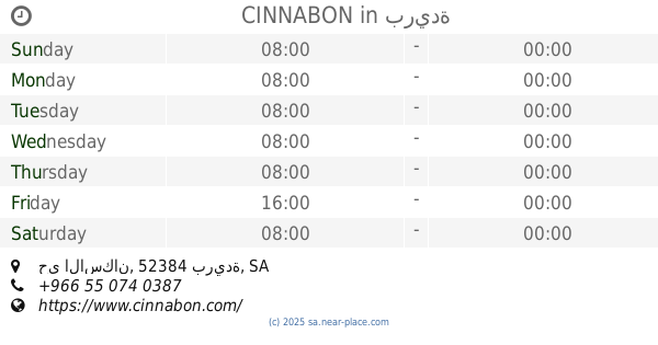
CINNABON
حي الاسكان، بريدة
Bakery
read more
4.222 km
قرصان ومصابيب عبدالله
شارع عمربن سليم، حي سلطانة، بريدة
Bakery
read more
4.362 km
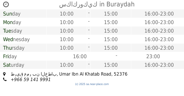
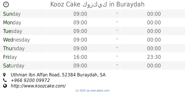
Kooz Cake كوزكيك
Uthman Ibn Affan Road, Buraydah
Bakery
read more
📑
all categories
Accounting
Administrative area level 1
Airport
Amusement park
Aquarium
Art gallery
Atm
Bakery
Bank
Bar
Beauty salon
Bicycle store
Book store
Bowling alley
Bus station
Cafe
Campground
Car dealer
Car rental
Car repair
Car wash
Casino
Cemetery
Church
City hall
Clothing store
Colloquial area
Convenience store
Country
Courthouse
Dentist
Department store
Doctor
Electrician
Electronics store
Embassy
Finance
Fire station
Florist
Food
Funeral home
Furniture store
Gas station
General contractor
Grocery or supermarket
Gym
Hair care
Hardware store
Health
Hindu Temple
Home goods store
Hospital
Insurance agency
Intersection
Jewelry store
Laundry
Lawyer
Library
Light rail station
Liquor store
Local government office
Locality
Locksmith
Lodging
Meal delivery
Meal takeaway
Mosque
Movie rental
Movie theater
Moving company
Museum
Natural feature
Neighborhood
Night club
Painter
Park
Parking
Pet store
Pharmacy
Physiotherapist
Place of worship
Plumber
Point of interest
Police
Political
Post office
Premise
Real estate agency
Restaurant
Roofing contractor
Route
Rv park, camping
School
Shoe store
Shopping mall
Spa
Stadium
Storage
Store
Sublocality
Subpremise
Subway station
Supermarket
Taxi stand
Train station
Transit station
Travel agency
University
Veterinary care
Zoo
sublocality level 1
↑