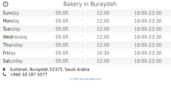
Bakery nearby مخبز الحفيتي
Saudi Arabia
Bakery nearby مخبز الحفيتي
مخبز الحفيتي
طريق الملك فهد، حي البصر, 52543, بريدة, SA Saudi Arabia
contacts phone
:
+966 55 514 5035
Latitude:
26.3013806
, Longitude:
43.8523675
larger map & directions
read more
nearest Bakery
1.34 km
Tmis Bakery
Buraydah
Bakery
read more
1.832 km
Konafa Fares
3030, Buraydah
Bakery
read more
7.122 km
مخبز
طريق الملك فهد، حي الحمر، بريدة
Bakery
read more
7.635 km
مخبز
شارع عمر بن سليم، الشقة، بريدة
Bakery
read more
7.639 km
مخبز تميس
شارع الشقة ، حي سلطانة، بريدة
Bakery
read more
8.259 km
مخبز تميس
الشقة، بريدة
Bakery
read more
8.409 km
مخبز
Buraydah
Bakery
read more
9.059 km
مخبز تميس
حي الشقة، بريدة
Bakery
read more
9.133 km
Bakery and voiles Hoilan
7425 Al Huwailan, Buraydah
Bakery
read more
9.18 km
قرصان ومصابيب عبدالله
شارع عمربن سليم، حي سلطانة، بريدة
Bakery
read more
9.378 km
Bakery
Buraydah
Bakery
read more
9.426 km
قرصان ومصابيب
شارع عمر بن سليم، حي سلطانة، بريدة
Bakery
read more
10.208 km
قرصان عبدالله علي الغفيص
طريق الأمير فيصل بن مشعل بن سعود، حي مشعل، بريدة
Bakery
read more
10.237 km
NIS Sweets
Prince Faisal Ibn Mishaal Ibn Saud Road, Buraydah
Bakery
read more
10.243 km
مخبز وفوال
Buraydah
Bakery
read more
10.262 km
محل قرصان
شارع الثمانين، حي البصيرية، بريدة
Bakery
read more
10.343 km
Faran
Buraydah
Bakery
read more
10.573 km
Jood
Umar Ibn Al Khatab Road, Buraydah
Bakery
read more
10.63 km
مخبز
شارع عمر بن سليم, Buraydah
Bakery
read more
10.796 km
حلويات كيان
King Abdulaziz Road, Buraydah
Bakery
read more
10.832 km
قرصان
طريق الملك فيصل، الموطا، بريدة
Bakery
read more
10.865 km
مخبر تميس نوره راشد الحميد
طريق الملك فهد، حي المنتزه، بريدة
Bakery
read more
10.897 km
قرصان ومصابيب
طريق الامير فيصل بن مشعل ، حي التغيرة، بريدة
Bakery
read more
10.935 km
مخبز صالح الربيان
طريق الأمير فيصل بن مشعل، حي التغيرة، بريدة
Bakery
read more
11.188 km
قرصان عبدالله علي سليمان الغفيص
طريق القناة، حي الهلال، بريدة
Bakery
read more
📑
all categories
Accounting
Administrative area level 1
Airport
Amusement park
Aquarium
Art gallery
Atm
Bakery
Bank
Bar
Beauty salon
Bicycle store
Book store
Bowling alley
Bus station
Cafe
Campground
Car dealer
Car rental
Car repair
Car wash
Casino
Cemetery
Church
City hall
Clothing store
Colloquial area
Convenience store
Country
Courthouse
Dentist
Department store
Doctor
Electrician
Electronics store
Embassy
Finance
Fire station
Florist
Food
Funeral home
Furniture store
Gas station
General contractor
Grocery or supermarket
Gym
Hair care
Hardware store
Health
Hindu Temple
Home goods store
Hospital
Insurance agency
Intersection
Jewelry store
Laundry
Lawyer
Library
Light rail station
Liquor store
Local government office
Locality
Locksmith
Lodging
Meal delivery
Meal takeaway
Mosque
Movie rental
Movie theater
Moving company
Museum
Natural feature
Neighborhood
Night club
Painter
Park
Parking
Pet store
Pharmacy
Physiotherapist
Place of worship
Plumber
Point of interest
Police
Political
Post office
Premise
Real estate agency
Restaurant
Roofing contractor
Route
Rv park, camping
School
Shoe store
Shopping mall
Spa
Stadium
Storage
Store
Sublocality
Subpremise
Subway station
Supermarket
Taxi stand
Train station
Transit station
Travel agency
University
Veterinary care
Zoo
sublocality level 1
↑