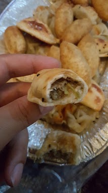
Bakery nearby Tmis Bakery
Saudi Arabia
Bakery nearby Tmis Bakery
Tmis Bakery
255, 62461, Khamis Mushait, SA Saudi Arabia
contacts phone
:
+966
Latitude:
18.2986932
, Longitude:
42.7393833
larger map & directions
read more
nearest Bakery
879 m
المخبز البلدي
حي أم سرار، خميس مشيط
Bakery
read more
964 m
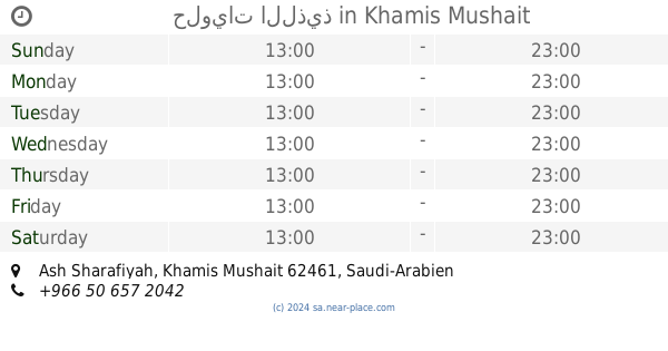
حلويات اللذيذ
Khamis Mushait
Bakery
read more
1.08 km
معجنات البخاري للأكلات الحجازية
شارع الملك فهد، خميس مشيط
Bakery
read more
1.131 km
فرن تميس البخاري
Khamis Mushait
Bakery
read more
1.201 km
حلويات لارج سويت
طريق الرياض، خميس مشيط
Bakery
read more
1.231 km
Lebanon Bakery
255, Khamis Mushait
Bakery
read more
1.278 km
وقت الكيك
حي النخيل، خميس مشيط
Bakery
read more
1.487 km
Super Market Bin Halaash
Khamis Mushait
Bakery
read more
1.649 km
مخبز رواد الحي
Khamis Mushait
Bakery
read more
1.712 km
Delicious cake (ornaments Basbousa)
8885 سوسة، النسيم خميس مشيط 62465 4293 Susah, Khamis Mushait
Bakery
read more
1.907 km
Egyptian bakery
Khamis Mushait
Bakery
read more
1.97 km
مخابز وتموينات المحيميد
الهملية، خميس مشيط
Bakery
read more
1.97 km
مخابز الجمرة الآلية
حي الهميلة، خميس مشيط
Bakery
read more
2.587 km
ركن الفطائر
طريق الملك فيصل، خميس مشيط
Bakery
read more
2.59 km
معجنات وحلويات فاطمه
طريق عمر بن الخطاب، حي شباعة، خميس مشيط
Bakery
read more
2.72 km
Donut Sugar
طريق الملك فيصل، طريق المدينة العسكرية، خميس مشيط
Bakery
read more
2.917 km
شركة عبدالعزيز ومنصور البابطين
حي الضيافة، خميس مشيط
Bakery
read more
3.104 km
مخابز وحلويات الدانة الآلية
الحي الراقي، خميس مشيط
Bakery
read more
3.413 km
Manakish countryside
8458 صلاح الدين، حي الضيافة، خميس مشيط
Bakery
read more
3.429 km
Prince pies
صلاح الدين، خميس مشيط
Bakery
read more
3.645 km
Bakeries Zain 5
تولان سنتر، طريق المدينة العسكرية، حي الراقي، خميس مشيط
Bakery
read more
3.661 km
معجنات الحجازيه
Near Civil Defence, Ar Raqi، خميس مشيط
Bakery
read more
4.15 km
الرهاف للمعجنات
8743, Khamis Mushait
Bakery
read more
4.571 km
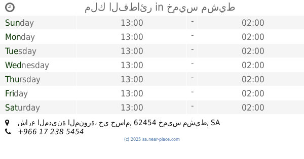
مخبز تميس غرناطة
Khamis Mushait
Bakery
read more
4.884 km
ملك الفطائر
شارع المدينة المنورة، حي حسام، خميس مشيط
Bakery
read more
📑
all categories
Accounting
Administrative area level 1
Airport
Amusement park
Aquarium
Art gallery
Atm
Bakery
Bank
Bar
Beauty salon
Bicycle store
Book store
Bowling alley
Bus station
Cafe
Campground
Car dealer
Car rental
Car repair
Car wash
Casino
Cemetery
Church
City hall
Clothing store
Colloquial area
Convenience store
Country
Courthouse
Dentist
Department store
Doctor
Electrician
Electronics store
Embassy
Finance
Fire station
Florist
Food
Funeral home
Furniture store
Gas station
General contractor
Grocery or supermarket
Gym
Hair care
Hardware store
Health
Hindu Temple
Home goods store
Hospital
Insurance agency
Intersection
Jewelry store
Laundry
Lawyer
Library
Light rail station
Liquor store
Local government office
Locality
Locksmith
Lodging
Meal delivery
Meal takeaway
Mosque
Movie rental
Movie theater
Moving company
Museum
Natural feature
Neighborhood
Night club
Painter
Park
Parking
Pet store
Pharmacy
Physiotherapist
Place of worship
Plumber
Point of interest
Police
Political
Post office
Premise
Real estate agency
Restaurant
Roofing contractor
Route
Rv park, camping
School
Shoe store
Shopping mall
Spa
Stadium
Storage
Store
Sublocality
Subpremise
Subway station
Supermarket
Taxi stand
Train station
Transit station
Travel agency
University
Veterinary care
Zoo
sublocality level 1
↑