Cafe nearby اضواء القمر
Saudi Arabia
Cafe nearby اضواء القمر
اضواء القمر
2147 Prince Sultan Road, Khamis Mushait Arabia Saudyjska
contacts phone
:
+966
Latitude:
18.3408817
, Longitude:
42.779972
read more
nearest Cafe
56 m
MEMORY COFFEE
طريق الرياض، حي موسى، خميس مشيط
Cafe
read more
61 m
Coffee way
9768 Prince Sultan Road, 5164, Khamis Mushait
Cafe
read more
1.358 km
كوفي
Khamis Mushait
Cafe
read more
1.454 km
QUEEN CAFE
Khamis Mushait
Cafe
read more
1.496 km
Casino and coffee Dana
8289 طريق الملك سلطان، حي الموسي، خميس مشيط
Cafe
read more
1.763 km
مقهى الموعد vip
Prince Sultan Road, Khamis Mushait
Cafe
read more
1.944 km
تيفاني كافيه
حي الراقي، خميس مشيط
Cafe
read more
2.298 km
دانكن دونتس | Dunkin’ Donuts
Khamis Mushait
Cafe
read more
2.359 km
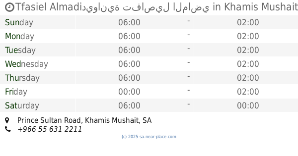
Tfasiel Almadiديوانية تفاصيل الماضي
Prince Sultan Road, Khamis Mushait
Cafe
read more
2.405 km
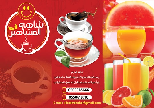
شاهي المشاهير
طريق الرياض، حي موسى، خميس مشيط
Cafe
read more
2.501 km
كافيه الراحه
طريق الرياض، حي المومن، خميس مشيط
Cafe
read more
2.558 km
مهيلة الخليج
Khamis Mushait
Cafe
read more
2.575 km
محل تمور اسيف لمستلزمات القهوة وشاي وطحين
5034, Khamis Mushait
Cafe
read more
3.795 km
مقهى وكفي شوب وبلاي ستيشن روما
طريق الملك سعود،, Khamis Mushait
Cafe
read more
3.795 km
مقهي سطانه
طريق وادي بن هشبل قهوه السطانه ، خميس مشيط،, Khamis Mushait
Cafe
read more
3.795 km
مقهى كايرو
3642, مخطط الموسى،, Khamis Mushait
Cafe
read more
3.795 km
الصمده
Khamis Mushait
Cafe
read more
3.973 km
Dunkindonuts Bakery
6881, Khamis Mushait
Cafe
read more
4.201 km
مقهى وعصائر ركن النجوم
Khamis Mushait
Cafe
read more
4.208 km
مقهى ركن الديوان
Khamis Mushait
Cafe
read more
4.241 km
العرائسي (للعصيرات الطازجة)
العزيزية،, Khamis Mushait
Cafe
read more
4.319 km
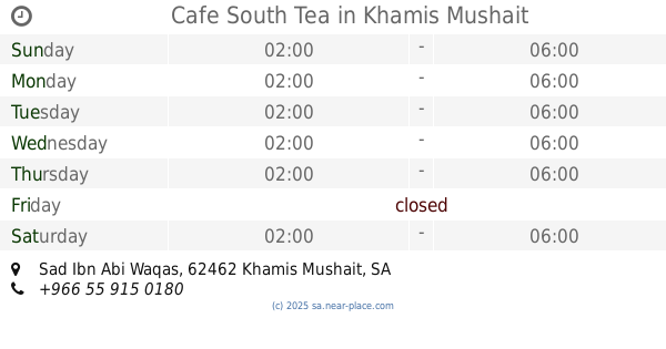
Cafe South Tea
Sad Ibn Abi Waqas, Khamis Mushait
Cafe
read more
4.507 km
مقهي ومنتزه وناسه
80th Street, Khamis Mushait
Cafe
read more
4.514 km
مقهى السحاب
Khamis Mushait
Cafe
read more
4.546 km
مهيلة رعد الشمال
تندحة، خط الرياض، خميس مشيط
Cafe
read more
📑
all categories
Accounting
Administrative area level 1
Airport
Amusement park
Aquarium
Art gallery
Atm
Bakery
Bank
Bar
Beauty salon
Bicycle store
Book store
Bowling alley
Bus station
Cafe
Campground
Car dealer
Car rental
Car repair
Car wash
Casino
Cemetery
Church
City hall
Clothing store
Colloquial area
Convenience store
Country
Courthouse
Dentist
Department store
Doctor
Electrician
Electronics store
Embassy
Finance
Fire station
Florist
Food
Funeral home
Furniture store
Gas station
General contractor
Grocery or supermarket
Gym
Hair care
Hardware store
Health
Hindu Temple
Home goods store
Hospital
Insurance agency
Intersection
Jewelry store
Laundry
Lawyer
Library
Light rail station
Liquor store
Local government office
Locality
Locksmith
Lodging
Meal delivery
Meal takeaway
Mosque
Movie rental
Movie theater
Moving company
Museum
Natural feature
Neighborhood
Night club
Painter
Park
Parking
Pet store
Pharmacy
Physiotherapist
Place of worship
Plumber
Point of interest
Police
Political
Post office
Premise
Real estate agency
Restaurant
Roofing contractor
Route
Rv park, camping
School
Shoe store
Shopping mall
Spa
Stadium
Storage
Store
Sublocality
Subpremise
Subway station
Supermarket
Taxi stand
Train station
Transit station
Travel agency
University
Veterinary care
Zoo
sublocality level 1
↑