Cafe nearby ALHGHAGI
Saudi Arabia
Cafe nearby ALHGHAGI
ALHGHAGI
23466, Jeddah Saudi Arabia
contacts phone
:
+966
Latitude:
21.5966372
, Longitude:
39.2609739
read more
nearest Cafe
5 m
Diwaniya elite
Harmalah Bin Al Walid, Jeddah
Cafe
read more
732 m
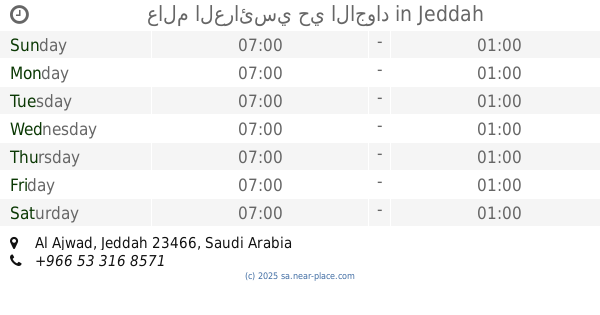
عالم العرائسي حي الاجواد
Jeddah
Cafe
read more
759 m
الشموخ للمعسلات
جدة
Cafe
read more
817 m
الديوانيه
3965 جبل معبر, حي الاجواد،, Jeddah
Cafe
read more
1.011 km
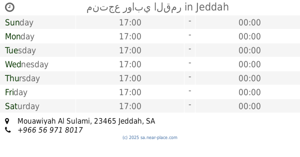
منتجع روابي القمر
Mouawiyah Al Sulami, Jeddah
Cafe
read more
1.027 km
Coffee and Diwaniya
Jeddah
Cafe
read more
1.052 km
ديوانية دلة الشيوخ بالأجواد
2993 صهيب أبوموسى، حي الاجواد جدة 23466
Cafe
read more
1.061 km
Colors Coffee Cafe
2757, حي الاجواد،, Jeddah
Cafe
read more
1.076 km
Venjal science Men
صالح بن ابراهيم الزهري, Jeddah
Cafe
read more
1.076 km
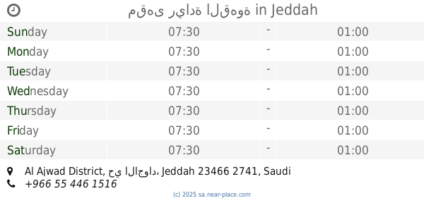
مقهى ريادة القهوة
6675, Al Ajwad District, Jeddah
Cafe
read more
1.114 km
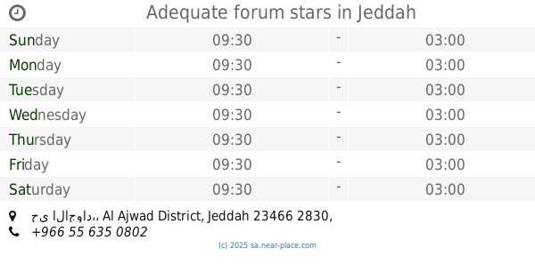
Adequate forum stars
6355, حي الاجواد،, Jeddah
Cafe
read more
1.156 km
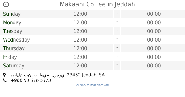
Makaani Coffee
صالح بن إبراهيم الزهري, Jeddah
Cafe
read more
1.166 km
مداري كافيه
صالح بن ابراهيم الزهري،، جدة
Cafe
read more
1.171 km
Masjid
السامر، جدة
Cafe
read more
1.331 km
Diwaniya ore Cafe
7745 م سليم بنت ملحان, حي الاجواد, Jeddah
Cafe
read more
1.332 km
Diwaniya ore Cafe
Mouawiyah Al Sulami, Jeddah
Cafe
read more
1.463 km
جبل الثلج
عبدالله بن عطاء, Jeddah
Cafe
read more
1.496 km
ديوانية الاجواد
Jeddah
Cafe
read more
1.61 km
قهوة مختصة
Unnamed Road, Jeddah
Cafe
read more
1.61 km
Brew & Blend
Unnamed Road, Jeddah
Cafe
read more
1.675 km
Brew & Blend برو اند بلند
4627 Al Manar, Al Manar District, Jeddah
Cafe
read more
1.675 km
Brew & Blend برو اند بلند
Al Manar District 4627, Jeddah
Cafe
read more
1.802 km
قهوة الجبل
Unnamed Road, Jeddah
Cafe
read more
1.86 km
Mountain folk cafe
Jeddah
Cafe
read more
1.874 km
دربي كافية
Jeddah
Cafe
read more
📑
all categories
Accounting
Administrative area level 1
Airport
Amusement park
Aquarium
Art gallery
Atm
Bakery
Bank
Bar
Beauty salon
Bicycle store
Book store
Bowling alley
Bus station
Cafe
Campground
Car dealer
Car rental
Car repair
Car wash
Casino
Cemetery
Church
City hall
Clothing store
Colloquial area
Convenience store
Country
Courthouse
Dentist
Department store
Doctor
Electrician
Electronics store
Embassy
Finance
Fire station
Florist
Food
Funeral home
Furniture store
Gas station
General contractor
Grocery or supermarket
Gym
Hair care
Hardware store
Health
Hindu Temple
Home goods store
Hospital
Insurance agency
Intersection
Jewelry store
Laundry
Lawyer
Library
Light rail station
Liquor store
Local government office
Locality
Locksmith
Lodging
Meal delivery
Meal takeaway
Mosque
Movie rental
Movie theater
Moving company
Museum
Natural feature
Neighborhood
Night club
Painter
Park
Parking
Pet store
Pharmacy
Physiotherapist
Place of worship
Plumber
Point of interest
Police
Political
Post office
Premise
Real estate agency
Restaurant
Roofing contractor
Route
Rv park, camping
School
Shoe store
Shopping mall
Spa
Stadium
Storage
Store
Sublocality
Subpremise
Subway station
Supermarket
Taxi stand
Train station
Transit station
Travel agency
University
Veterinary care
Zoo
sublocality level 1
↑