Cafe nearby Autad cafe
Saudi Arabia
Cafe nearby Autad cafe
Autad cafe
3133, Abdullah Ibn Ar Rabi, 23531, Jeddah, SA Saudi Arabia
contacts phone
:
+966
Latitude:
21.6139371
, Longitude:
39.1670849
larger map & directions
read more
nearest Cafe
360 m
مودك كافيه
Jeddah
Cafe
read more
400 m
رمسيس كافيه للشباب
Unnamed Road الربوة جدة 23533, مقابل البنك الراجحي, Jeddah
Cafe
read more
421 m
معازيم كافيه
Jeddah
Cafe
read more
431 m
كافيه سكاي Sky Cafe
6431 طريق الملك فهد، حي النزهة، جدة 23534
Cafe
read more
431 m
كافيه سكاي
6431 طريق الملك فهد، حي النزهة، جدة 23534
Cafe
read more
432 m
معازيم
شارع حراء، حي الربوة، جدة
Cafe
read more
454 m
كوفي جمعان
شارع حراء،, Jeddah
Cafe
read more
509 m
Rosha Juices
Jeddah
Cafe
read more
543 m
Bonnon Coffee
Hira Street, Jeddah
Cafe
read more
583 m
Professinal Cafe
Jeddah
Cafe
read more
642 m
مقهى بلايستيشن الكلاسيكو
2575 حراء, حي البوادي, Jeddah
Cafe
read more
644 m
Qariat Al-Finjal Cafe مقهى قارئة الفنجال
4082 Hira Street, Jeddah
Cafe
read more
647 m
مقهي بلاستيشن كلاسيكو
7867 Al Majma, حي البوادي, Jeddah
Cafe
read more
693 m
ديوانيه كمبنسكي
3241 سلطان بن سلمان، حي النزهة جدة 23532
Cafe
read more
695 m
Feroz Cafe
3241 Sultan Ibn Salman, حي النزهة،, Jeddah
Cafe
read more
738 m
ديوانية مهند
6582 غضا ابو فرانس، حي النزهة جدة 23534
Cafe
read more
740 m
ديوانية مهند السليمان
Jeddah
Cafe
read more
742 m
مقهى ليالينا
King Fahd Road, Jeddah
Cafe
read more
768 m
معسلات جدة
Jeddah
Cafe
read more
817 m
Carየእኔ
3918 Sultan Ibn Salman, An Nuzhah District, Jeddah 23534 6788 Sultan Ibn Salman, Jeddah
Cafe
read more
823 m
بوفية الفتح
Unnamed Road, Jeddah
Cafe
read more
825 m
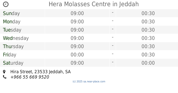
Hera Molasses Centre
Hira Street, Jeddah
Cafe
read more
1.236 km
ديوانية صدى الملاعب
حي الربوة، جدة
Cafe
read more
1.237 km
Sayyartek Cafe
Jeddah
Cafe
read more
1.239 km
ديوانية صدى الملاعب
الربوة،, Jeddah
Cafe
read more
📑
all categories
Accounting
Administrative area level 1
Airport
Amusement park
Aquarium
Art gallery
Atm
Bakery
Bank
Bar
Beauty salon
Bicycle store
Book store
Bowling alley
Bus station
Cafe
Campground
Car dealer
Car rental
Car repair
Car wash
Casino
Cemetery
Church
City hall
Clothing store
Colloquial area
Convenience store
Country
Courthouse
Dentist
Department store
Doctor
Electrician
Electronics store
Embassy
Finance
Fire station
Florist
Food
Funeral home
Furniture store
Gas station
General contractor
Grocery or supermarket
Gym
Hair care
Hardware store
Health
Hindu Temple
Home goods store
Hospital
Insurance agency
Intersection
Jewelry store
Laundry
Lawyer
Library
Light rail station
Liquor store
Local government office
Locality
Locksmith
Lodging
Meal delivery
Meal takeaway
Mosque
Movie rental
Movie theater
Moving company
Museum
Natural feature
Neighborhood
Night club
Painter
Park
Parking
Pet store
Pharmacy
Physiotherapist
Place of worship
Plumber
Point of interest
Police
Political
Post office
Premise
Real estate agency
Restaurant
Roofing contractor
Route
Rv park, camping
School
Shoe store
Shopping mall
Spa
Stadium
Storage
Store
Sublocality
Subpremise
Subway station
Supermarket
Taxi stand
Train station
Transit station
Travel agency
University
Veterinary care
Zoo
sublocality level 1
↑