Cafe nearby Cafe direction coffee
Saudi Arabia
Cafe nearby Cafe direction coffee
Cafe direction coffee
طريق الإمام عبدالله بن سعود بن عبدالعزيز Imam Abdullah Ibn Saud Ibn Abdulaziz Road, Riyadh Saudi Arabia
contacts phone
:
+966
Latitude:
24.7822928
, Longitude:
46.7437577
read more
nearest Cafe
17 m
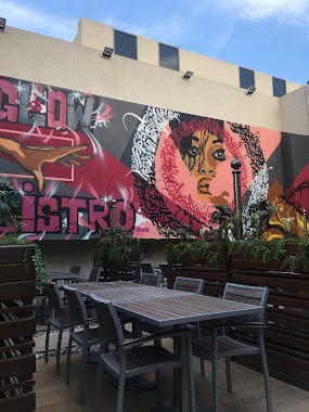
جلوبيسترو
شارع الامام سعود ، حي غرناطة، الرياض
Cafe
read more
17 m
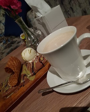
اتجاه القهوة
شارع الامام سعود، حي غرناطة، الرياض
Cafe
read more
92 m
CREPE CAR
Riyadh
Cafe
read more
281 m
هافان
شارع الامام سعود - حي غرناطة، الرياض
Cafe
read more
294 m
kizan Cooffee
Imam Abdullah Ibn Saud Ibn Abdulaziz Road, Riyadh
Cafe
read more
307 m
Courtyard
مستشفى سند, طريق الإمام سعود بن عبد العزيز مقابل, Riyadh
Cafe
read more
338 m
Lewis & Carroll
4492 Imam Abdullah Ibn Saud Ibn Abdulaziz Road, 6828, Riyadh
Cafe
read more
399 m
De Journal Café
4220 Suraqat Ibn Amr, Riyadh
Cafe
read more
545 m
Laama Palm Cafe
6083 Khalid Ibn Al Walid Street, Riyadh
Cafe
read more
563 m
Buqshah Cafe
Khalid Ibn Al Walid Street, Riyadh
Cafe
read more
569 m
Cinnabon
Khalid Ibn Al Walid Street, Riyadh
Cafe
read more
576 m
Java Time
7675 Khalid Ibn Al Walid St, Al Hamra, Riyadh 13217 2100 Khalid Ibn Al Walid Street, Riyadh
Cafe
read more
586 m
Coffee Aroma
Khalid Ibn Al Walid Street, Riyadh
Cafe
read more
657 m
Fouchy Cafe
Imam Abdullah Ibn Saud Ibn Abdulaziz Branch Road, Riyadh
Cafe
read more
749 m
Arena
3979 الخضراء, 8109, Riyadh
Cafe
read more
750 m
Arina cafe
8194 Khalid Ibn Al Walid Street, Riyadh
Cafe
read more
824 m
Parole Cafee
Riyadh
Cafe
read more
836 m
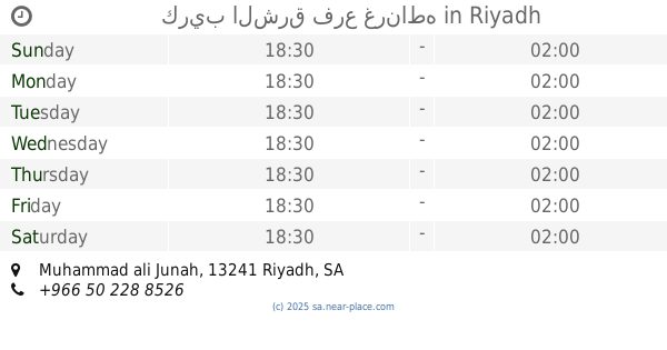
قهوة و كرك
Mohammad Ali junah, Riyadh
Cafe
read more
896 m
كريب الشرق فرع غرناطه
Muhammad ali Junah, Riyadh
Cafe
read more
904 m
Coffee Stamp
Riyadh
Cafe
read more
912 m
اشجان فيروز
محمد علي جناح، الشهداء، الرياض
Cafe
read more
935 m
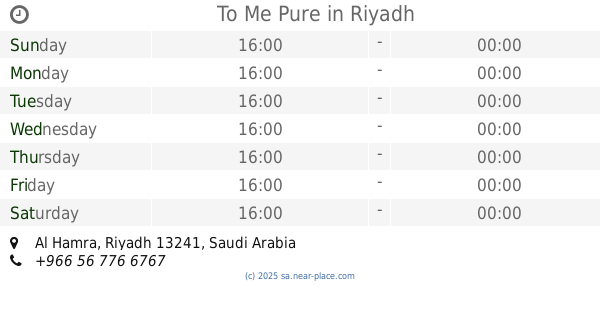
To Me Pure
Riyadh
Cafe
read more
951 m
اشجان فيروز كافية
Riyadh
Cafe
read more
953 m
اشجان فيروز كافيه
Abi Jafar Al Mansur, Riyadh
Cafe
read more
954 m
رنوش
محمد علي جناح، الشهداء، الرياض
Cafe
read more
📑
all categories
Accounting
Administrative area level 1
Airport
Amusement park
Aquarium
Art gallery
Atm
Bakery
Bank
Bar
Beauty salon
Bicycle store
Book store
Bowling alley
Bus station
Cafe
Campground
Car dealer
Car rental
Car repair
Car wash
Casino
Cemetery
Church
City hall
Clothing store
Colloquial area
Convenience store
Country
Courthouse
Dentist
Department store
Doctor
Electrician
Electronics store
Embassy
Finance
Fire station
Florist
Food
Funeral home
Furniture store
Gas station
General contractor
Grocery or supermarket
Gym
Hair care
Hardware store
Health
Hindu Temple
Home goods store
Hospital
Insurance agency
Intersection
Jewelry store
Laundry
Lawyer
Library
Light rail station
Liquor store
Local government office
Locality
Locksmith
Lodging
Meal delivery
Meal takeaway
Mosque
Movie rental
Movie theater
Moving company
Museum
Natural feature
Neighborhood
Night club
Painter
Park
Parking
Pet store
Pharmacy
Physiotherapist
Place of worship
Plumber
Point of interest
Police
Political
Post office
Premise
Real estate agency
Restaurant
Roofing contractor
Route
Rv park, camping
School
Shoe store
Shopping mall
Spa
Stadium
Storage
Store
Sublocality
Subpremise
Subway station
Supermarket
Taxi stand
Train station
Transit station
Travel agency
University
Veterinary care
Zoo
sublocality level 1
↑