Cafe nearby دلة السلطان
Saudi Arabia
Cafe nearby دلة السلطان
دلة السلطان
طريق الملك عبد العزيز، حي الفاخرية, 34264, الدمام, SA Saudi Arabia
contacts phone
:
+966 50 427 7774
Latitude:
26.3327191
, Longitude:
50.0903458
larger map & directions
read more
nearest Cafe
112 m
قهوة الطريق - Road Café
طريق الملك عبد العزيز، الشعلة، الدمام
Cafe
read more
112 m
قهوة الطريق - Road Café
4016 King Abdulaziz Rd, Ash Shulah Dammam, Dammam
Cafe
read more
1.955 km
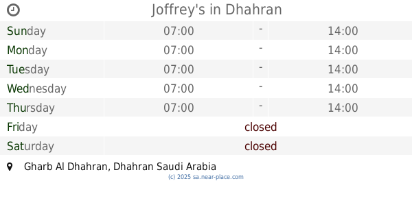
Joffrey's
8292, 5549, Dhahran
Cafe
read more
2.693 km
Fenjal AlSharq
الشعلة، حي الفاخرية، الدمام
Cafe
read more
2.741 km
Venjal East
5551, Dammam
Cafe
read more
2.741 km
Fenjal AlSharq
5551, Dammam
Cafe
read more
3.211 km
Starbucks Coffee
Inside Energy Center, Ithraa, Dhahran
Cafe
read more
3.362 km
Manto rose FAKHRIYA2
Dammam
Cafe
read more
3.492 km
Joffrey's
Dhahran
Cafe
read more
3.57 km
Walley Coffee
Dammam
Cafe
read more
3.623 km
Tamimi Cafeteria
Dhahran
Cafe
read more
3.686 km
Evening Board
Dammam
Cafe
read more
3.833 km
محامص كيف النشاما للقهوة العربية
Dammam
Cafe
read more
3.836 km
Season Cafe
5051, Dammam
Cafe
read more
3.905 km
مقهى قيصر العرب
Dammam
Cafe
read more
3.915 km
شاي الحارة
4998 الامام محمد بن عبد الوهاب, Dammam
Cafe
read more
3.954 km
Diwaniya Al Aljaweed
Dammam
Cafe
read more
3.979 km
مقهى كيف النشاما
شارع الإمام محمد بن عبدالوهاب،، الدمام
Cafe
read more
3.986 km
Neshama Cafe
طيبة،شارع الإمام محمد بن عبدالوهاب، الدمام
Cafe
read more
3.994 km
مقهى النشاماء
الدمام
Cafe
read more
4.169 km
Majestic Cup
Dammam
Cafe
read more
4.294 km
Bon Café
Dammam
Cafe
read more
4.406 km
مقهى الكيف الخليجي
Imam Muhammad Ibn Abdulwahab Street, Dammam
Cafe
read more
4.406 km
الكيف الخليجي
Imam Muhammad Ibn Abdulwahab Street, Dammam
Cafe
read more
4.417 km
ديوانية شعبيات المليون
شارع محمد عبدالوهاب ، حي الندي، الدمام
Cafe
read more
📑
all categories
Accounting
Administrative area level 1
Airport
Amusement park
Aquarium
Art gallery
Atm
Bakery
Bank
Bar
Beauty salon
Bicycle store
Book store
Bowling alley
Bus station
Cafe
Campground
Car dealer
Car rental
Car repair
Car wash
Casino
Cemetery
Church
City hall
Clothing store
Colloquial area
Convenience store
Country
Courthouse
Dentist
Department store
Doctor
Electrician
Electronics store
Embassy
Finance
Fire station
Florist
Food
Funeral home
Furniture store
Gas station
General contractor
Grocery or supermarket
Gym
Hair care
Hardware store
Health
Hindu Temple
Home goods store
Hospital
Insurance agency
Intersection
Jewelry store
Laundry
Lawyer
Library
Light rail station
Liquor store
Local government office
Locality
Locksmith
Lodging
Meal delivery
Meal takeaway
Mosque
Movie rental
Movie theater
Moving company
Museum
Natural feature
Neighborhood
Night club
Painter
Park
Parking
Pet store
Pharmacy
Physiotherapist
Place of worship
Plumber
Point of interest
Police
Political
Post office
Premise
Real estate agency
Restaurant
Roofing contractor
Route
Rv park, camping
School
Shoe store
Shopping mall
Spa
Stadium
Storage
Store
Sublocality
Subpremise
Subway station
Supermarket
Taxi stand
Train station
Transit station
Travel agency
University
Veterinary care
Zoo
sublocality level 1
↑