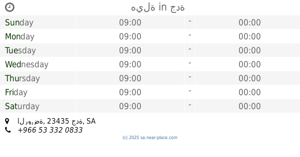
Cafe nearby FranCafé فران كافيه
Saudi Arabia
Cafe nearby FranCafé فران كافيه
FranCafé فران كافيه
Jeddah Saudi Arabia
contacts phone
:
+966
Latitude:
21.5674598
, Longitude:
39.1436487
read more
nearest Cafe
18 m
Fran Cafe
Jeddah
Cafe
read more
113 m
Mochachino
At Tayr, Jeddah
Cafe
read more
268 m
DXN DISTRIBUT
Balad Zahran, Jeddah
Cafe
read more
300 m
Laviecafe - لاڤي كافيه
Prince Sultan Rd Prince Sultan Road, AR Rawdah District, Jeddah
Cafe
read more
414 m
Barncafe بارن كافيه
Jeddah
Cafe
read more
530 m
برو٩٢
الروضة، جدة
Cafe
read more
538 m
هيلة
الروضة، جدة
Cafe
read more
539 m
درن ك كوفي + تي
الروضة، جدة
Cafe
read more
583 m
Pink Camel
Abdul Maqsud Khojah, Jeddah
Cafe
read more
583 m
مقهى مطعم الأصو
شارع عبدالمقصود خوجه _ حي الروضة، جدة
Cafe
read more
585 m
Brew 92
8681 طريق الأمير سلطان، حي الروضة جدة 23435
Cafe
read more
601 m
Brew 92° برو ٩٢
Prince Saud Al Faisal, Jeddah
Cafe
read more
611 m
Fleur De Pain
Jeddah
Cafe
read more
613 m
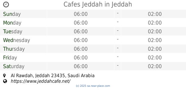
Cafes Jeddah
Jeddah
Cafe
read more
621 m
Cafe Bozaar
Abdul Maqsud Khojah, Jeddah
Cafe
read more
621 m
Cafe Beaux-art
Abdul Maqsud Khojah, Jeddah
Cafe
read more
623 m
Brew92 برو 92
الروضة, الروضة، جدة ، مركز الخياط, Jeddah
Cafe
read more
623 m
Brew92
الروضة, الروضة، جدة ، مركز الخياط, Jeddah
Cafe
read more
628 m
بوزار
شارع الامام ملك، جدة
Cafe
read more
636 m
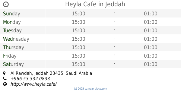
Heyla Cafe
Jeddah
Cafe
read more
651 m
ليبرا بوتيك ولاونج
Prince Saud Al Faisal, Jeddah
Cafe
read more
663 m
Solo
Ibn Al Kufi, Jeddah
Cafe
read more
721 m
Sky Lounge Cafe
Prince Sultan Road, Al Khalidiyah, Jeddah
Cafe
read more
723 m
Lavie Café
3750 Nur Al Bushra, Al Khalidiyah District,, Jeddah
Cafe
read more
826 m
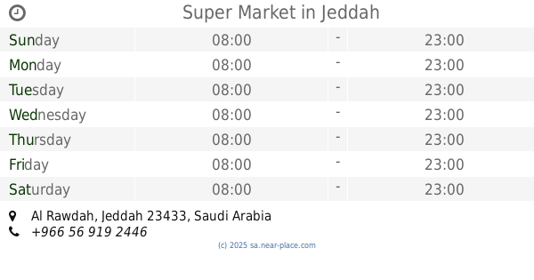
Super Market
Jeddah
Cafe
read more
📑
all categories
Accounting
Administrative area level 1
Airport
Amusement park
Aquarium
Art gallery
Atm
Bakery
Bank
Bar
Beauty salon
Bicycle store
Book store
Bowling alley
Bus station
Cafe
Campground
Car dealer
Car rental
Car repair
Car wash
Casino
Cemetery
Church
City hall
Clothing store
Colloquial area
Convenience store
Country
Courthouse
Dentist
Department store
Doctor
Electrician
Electronics store
Embassy
Finance
Fire station
Florist
Food
Funeral home
Furniture store
Gas station
General contractor
Grocery or supermarket
Gym
Hair care
Hardware store
Health
Hindu Temple
Home goods store
Hospital
Insurance agency
Intersection
Jewelry store
Laundry
Lawyer
Library
Light rail station
Liquor store
Local government office
Locality
Locksmith
Lodging
Meal delivery
Meal takeaway
Mosque
Movie rental
Movie theater
Moving company
Museum
Natural feature
Neighborhood
Night club
Painter
Park
Parking
Pet store
Pharmacy
Physiotherapist
Place of worship
Plumber
Point of interest
Police
Political
Post office
Premise
Real estate agency
Restaurant
Roofing contractor
Route
Rv park, camping
School
Shoe store
Shopping mall
Spa
Stadium
Storage
Store
Sublocality
Subpremise
Subway station
Supermarket
Taxi stand
Train station
Transit station
Travel agency
University
Veterinary care
Zoo
sublocality level 1
↑