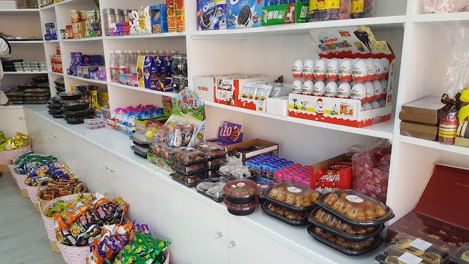
Cafe nearby حلويات الأميرة
Saudi Arabia
Cafe nearby حلويات الأميرة
حلويات الأميرة
الجش،، عنك 32467, Saudi Arabia
contacts phone
:
+966 54 886 8886
Latitude:
26.5149937
, Longitude:
49.9926015
larger map & directions
read more
nearest Cafe
722 m
DelooCaffe
6497، أم الحمام، عنك 32651
Cafe
read more
726 m
Alhayek Farm
Unnamed Road, Anak
Cafe
read more
958 m
Valentino Cafe فلنتينو كافيه
Anak
Cafe
read more
1.294 km
وافل يمي
Al Qatif
Cafe
read more
1.683 km
زراعة اللهو
الأنوار،, Anak
Cafe
read more
1.727 km
Farm Moyes
6809, Anak
Cafe
read more
1.78 km
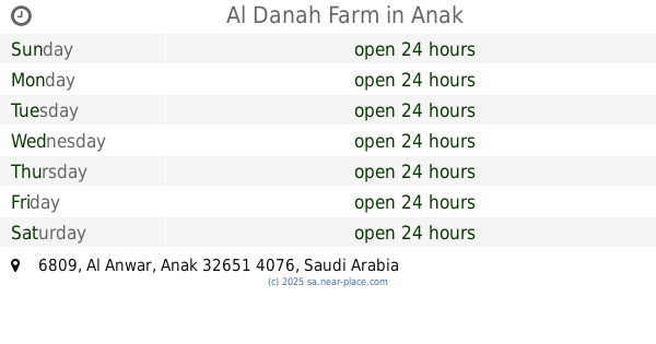
Al Danah Farm
Anak
Cafe
read more
1.786 km
Al Danah Farm
6809, Anak
Cafe
read more
1.798 km
دار رواق
Zain Alabideen Street, Anak
Cafe
read more
1.805 km
Galleria Cafe
Zain Alabideen Street, Anak
Cafe
read more
2.033 km
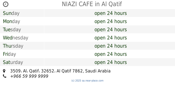
NIAZI CAFE
3509، Al، Qatif، 32652
Cafe
read more
2.051 km
Shabaab Cafe For Sheesha
8660, Safwa
Cafe
read more
2.697 km
Indian Food
2071 بدر, Al Qatif
Cafe
read more
2.834 km
استراحة ساره
Saihat
Cafe
read more
3.361 km
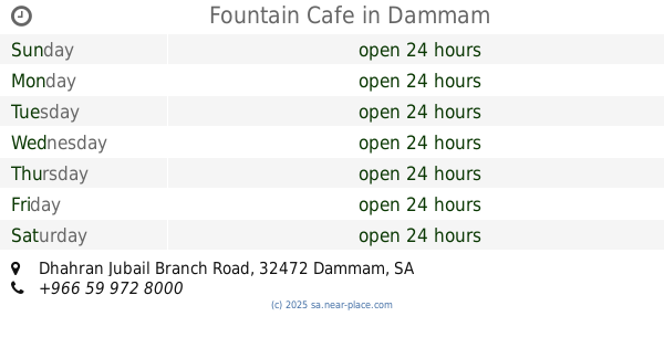
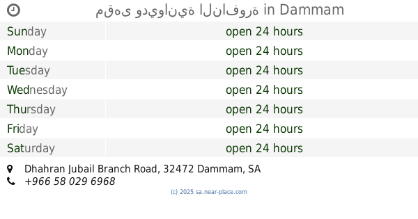
Fountain Cafe
Dhahran Jubail Branch Road, Dammam
Cafe
read more
3.364 km
مقهى وديوانية النافورة
Dhahran Jubail Branch Road, Dammam
Cafe
read more
3.366 km
الفحال
Al Qatif
Cafe
read more
3.568 km
عبدالله كوفي
ابو حدرية، صفوى
Cafe
read more
3.694 km
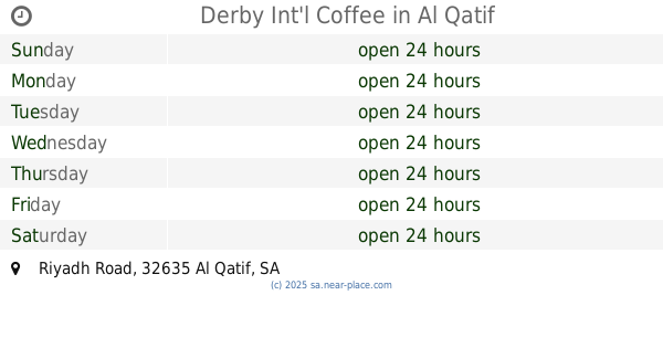
Derby Int'l Coffee
Riyadh Road, Al Qatif
Cafe
read more
3.714 km
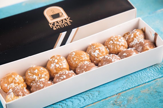
كرك وزيادة karak more
Khalid Ibn Al Walid Street, Anak
Cafe
read more
3.886 km
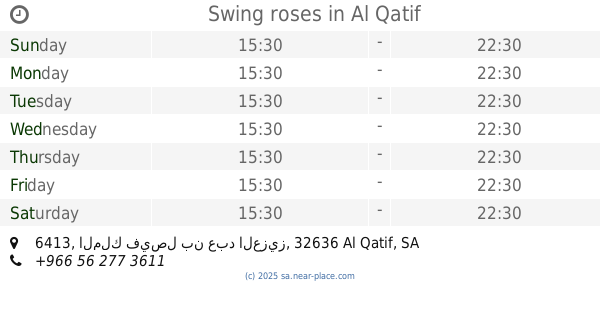
Rose Swing
6413 الملك فيصل بن عبد العزيز, Al Qatif
Cafe
read more
3.886 km
Swing roses
6413 الملك فيصل بن عبد العزيز, Al Qatif
Cafe
read more
4.035 km
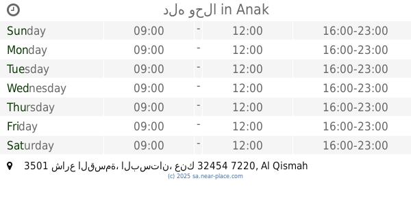
دله وحلا
3501 شارع القسمة، البستان، عنك 32454 7220 Al Qismah Street, Anak
Cafe
read more
4.082 km
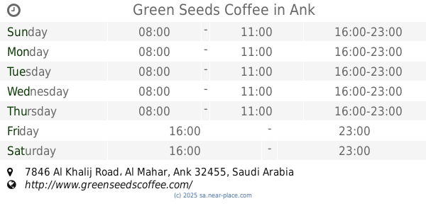
Green Seeds Coffee
7846 Al Khalij Road, Al Mahar, Anak
Cafe
read more
4.082 km
Green Seeds Coffee
7846 AlKhalij Road Eastern Province, Anak
Cafe
read more
📑
all categories
Accounting
Administrative area level 1
Airport
Amusement park
Aquarium
Art gallery
Atm
Bakery
Bank
Bar
Beauty salon
Bicycle store
Book store
Bowling alley
Bus station
Cafe
Campground
Car dealer
Car rental
Car repair
Car wash
Casino
Cemetery
Church
City hall
Clothing store
Colloquial area
Convenience store
Country
Courthouse
Dentist
Department store
Doctor
Electrician
Electronics store
Embassy
Finance
Fire station
Florist
Food
Funeral home
Furniture store
Gas station
General contractor
Grocery or supermarket
Gym
Hair care
Hardware store
Health
Hindu Temple
Home goods store
Hospital
Insurance agency
Intersection
Jewelry store
Laundry
Lawyer
Library
Light rail station
Liquor store
Local government office
Locality
Locksmith
Lodging
Meal delivery
Meal takeaway
Mosque
Movie rental
Movie theater
Moving company
Museum
Natural feature
Neighborhood
Night club
Painter
Park
Parking
Pet store
Pharmacy
Physiotherapist
Place of worship
Plumber
Point of interest
Police
Political
Post office
Premise
Real estate agency
Restaurant
Roofing contractor
Route
Rv park, camping
School
Shoe store
Shopping mall
Spa
Stadium
Storage
Store
Sublocality
Subpremise
Subway station
Supermarket
Taxi stand
Train station
Transit station
Travel agency
University
Veterinary care
Zoo
sublocality level 1
↑