Cafe nearby همسة مساء كافيه
Saudi Arabia
Cafe nearby همسة مساء كافيه
همسة مساء كافيه
4183, Asir Street, 13784, Riyadh, SA Saudi-Arabien
contacts phone
:
+966
Latitude:
24.6284495
, Longitude:
46.5473751
larger map & directions
read more
nearest Cafe
92 m
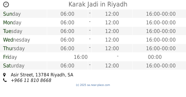
Karak Jadi
Asir Street, Riyadh
Cafe
read more
97 m
Karak Jadi
Assir Street, Riyadh
Cafe
read more
353 m
انضمة الرذاذ والضباب
ظهرة لبن،, Riyadh
Cafe
read more
390 m
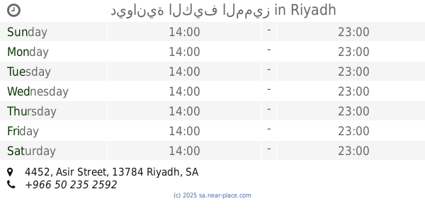
ديوانية الكيف المميز
4452 Asir Street, Riyadh
Cafe
read more
499 m
Friends Coffee
Assir Street, Riyadh
Cafe
read more
500 m
Friends Coffee
Asir Street, Riyadh
Cafe
read more
502 m
فريندز كافيه
3789 شارع عسير، الرياض
Cafe
read more
571 m
مقهى لانا الصحراء
7445 حائل، ظهرة لبن، الرياض 13784
Cafe
read more
693 m
Diwaniyat Al Qariah
Najran, Riyadh
Cafe
read more
713 m
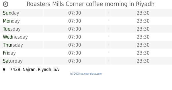
Roasters Mills Corner coffee morning
7429 Najran، Riyadh
Cafe
read more
713 m
Cafe last Venjal
3929 ينبع، ظهرة لبن الرياض 13784 8013 Yanbu, Riyadh
Cafe
read more
714 m
Solution and coffee violets
7429 Najran، Riyadh
Cafe
read more
771 m
IZMIR KAHUECISI
Riyadh
Cafe
read more
790 m
مقهى النكهات المنوعة
Tabuk Street, Riyadh
Cafe
read more
791 m
Coffee taste of autumn
Tabuk, Riyadh
Cafe
read more
819 m
كوفي نايت
7182 Najran, Riyadh
Cafe
read more
821 m
ريتشوني
شارع تبوك، ظهرة لبن، الرياض
Cafe
read more
830 m
ريتشوني
Tabuk, Riyadh
Cafe
read more
849 m
Smoothie Cafe
7552 شارع ينبع، ظهرة لبن، الرياض
Cafe
read more
869 m
هدوء المزاج
Asir Street, 7692 3059, Saudi, Riyadh
Cafe
read more
869 m
Cafe Mood
Asir Street, 7692 3059, Saudi, Riyadh
Cafe
read more
891 m
نسيم القهوة للسيدات
ينبع، ظهرة لبن،, Riyadh
Cafe
read more
990 m
Cafe 08:15
7818 خزام، ظهرة لبن الرياض 13782
Cafe
read more
1.056 km
وفاء قلامر
Dhahrat Laban, Riyadh
Cafe
read more
1.064 km
Drip Coffee
شارع عسير, ظهرة لبن، الرياض
Cafe
read more
📑
all categories
Accounting
Administrative area level 1
Airport
Amusement park
Aquarium
Art gallery
Atm
Bakery
Bank
Bar
Beauty salon
Bicycle store
Book store
Bowling alley
Bus station
Cafe
Campground
Car dealer
Car rental
Car repair
Car wash
Casino
Cemetery
Church
City hall
Clothing store
Colloquial area
Convenience store
Country
Courthouse
Dentist
Department store
Doctor
Electrician
Electronics store
Embassy
Finance
Fire station
Florist
Food
Funeral home
Furniture store
Gas station
General contractor
Grocery or supermarket
Gym
Hair care
Hardware store
Health
Hindu Temple
Home goods store
Hospital
Insurance agency
Intersection
Jewelry store
Laundry
Lawyer
Library
Light rail station
Liquor store
Local government office
Locality
Locksmith
Lodging
Meal delivery
Meal takeaway
Mosque
Movie rental
Movie theater
Moving company
Museum
Natural feature
Neighborhood
Night club
Painter
Park
Parking
Pet store
Pharmacy
Physiotherapist
Place of worship
Plumber
Point of interest
Police
Political
Post office
Premise
Real estate agency
Restaurant
Roofing contractor
Route
Rv park, camping
School
Shoe store
Shopping mall
Spa
Stadium
Storage
Store
Sublocality
Subpremise
Subway station
Supermarket
Taxi stand
Train station
Transit station
Travel agency
University
Veterinary care
Zoo
sublocality level 1
↑