Cafe nearby House ahly
Saudi Arabia
Cafe nearby House ahly
House ahly
6485, An Nabi, 14713, Riyadh, SA Saudi Arabia
contacts phone
:
+966 59010146
Latitude:
24.555848
, Longitude:
46.692947
larger map & directions
read more
nearest Cafe
733 m
لؤلؤة الشموع
6206 Ibn Taymeeyah Road, Riyadh
Cafe
read more
733 m
لؤلؤة الشموع
6206 طريق ابن تيمية، الرياض
Cafe
read more
738 m
ستايل كافية stylecoffee (عائلات/أفراد)
Riyadh
Cafe
read more
738 m
ستايل كافية stylecoffee (فرع العوائل)
Riyadh
Cafe
read more
745 m
صادق كافيه كلاسيك
6188 طريق ابن تيمية، الشفا الرياض 14713
Cafe
read more
771 m
قهوة ألوان الكيف
Riyadh
Cafe
read more
772 m
الااازظ
Riyadh
Cafe
read more
836 m
مقهى ديوانية الشفاء
طريق الإمام مالك، الرياض
Cafe
read more
904 m
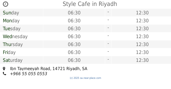
Style Cafe
Ibn Taymeeyah Road, Riyadh
Cafe
read more
919 m
juice shop alshifa riyadh
8151 Ibn Taymeeyah Rd, Badr, Riyadh 14724 2798 Ibn Taymeeyah Road, Riyadh
Cafe
read more
1.043 km
Sadiq Cafe
المثنى بن حارثة ,الشفا، الرياض
Cafe
read more
1.102 km
فخر الكيف للقهوة العربية
Al Muthanna Ibn Harithah, Riyadh
Cafe
read more
1.136 km
Style Coffee
Al Khalil Ibn Ahmad, Riyadh
Cafe
read more
1.229 km
محامص ومطاحن حمود
شارع الخليل بن احمد، الرياض
Cafe
read more
1.271 km
Dunkin' Donuts
Ibn Taymeeyah Road, Riyadh
Cafe
read more
1.365 km
Style Coffee
Ali Al Ansari, Riyadh
Cafe
read more
1.365 km
Coffee shop Style
Ali Al Ansari, Riyadh
Cafe
read more
1.515 km
Cafe Abu Haitham Al-Shifa
6664 سليمان بن ثمامة, Riyadh
Cafe
read more
1.532 km
خدمات الإنترنت
7481 Ibn Taymeeyah Road, Riyadh
Cafe
read more
1.54 km
4 Star Cafe
Riyadh
Cafe
read more
1.547 km
كافي أربعة نجوم
شارع الخليل بن أحمد، الرياض
Cafe
read more
1.549 km
محامص العبد الله
شارع الترمذي، الرياض
Cafe
read more
1.549 km
محامص العبد الله
شارع الترمذي, Riyadh
Cafe
read more
1.55 km
Coffin Cafe Drive Thero
At Turmudhi, Riyadh
Cafe
read more
1.585 km
اسيا كافية
6308 Ibn Taymeeyah Road, Riyadh
Cafe
read more
📑
all categories
Accounting
Administrative area level 1
Airport
Amusement park
Aquarium
Art gallery
Atm
Bakery
Bank
Bar
Beauty salon
Bicycle store
Book store
Bowling alley
Bus station
Cafe
Campground
Car dealer
Car rental
Car repair
Car wash
Casino
Cemetery
Church
City hall
Clothing store
Colloquial area
Convenience store
Country
Courthouse
Dentist
Department store
Doctor
Electrician
Electronics store
Embassy
Finance
Fire station
Florist
Food
Funeral home
Furniture store
Gas station
General contractor
Grocery or supermarket
Gym
Hair care
Hardware store
Health
Hindu Temple
Home goods store
Hospital
Insurance agency
Intersection
Jewelry store
Laundry
Lawyer
Library
Light rail station
Liquor store
Local government office
Locality
Locksmith
Lodging
Meal delivery
Meal takeaway
Mosque
Movie rental
Movie theater
Moving company
Museum
Natural feature
Neighborhood
Night club
Painter
Park
Parking
Pet store
Pharmacy
Physiotherapist
Place of worship
Plumber
Point of interest
Police
Political
Post office
Premise
Real estate agency
Restaurant
Roofing contractor
Route
Rv park, camping
School
Shoe store
Shopping mall
Spa
Stadium
Storage
Store
Sublocality
Subpremise
Subway station
Supermarket
Taxi stand
Train station
Transit station
Travel agency
University
Veterinary care
Zoo
sublocality level 1
↑