Cafe nearby Internet café and electronic services
Saudi Arabia
Cafe nearby Internet café and electronic services
Internet café and electronic services
طريق الملك فيصل, King Faisal Road, 62541, Abha, SA Saudi Arabia
contacts phone
:
+966 59 133 0306
website:
twitter.com
Latitude:
18.237203
, Longitude:
42.4995011
larger map & directions
read more
nearest Cafe
99 m
ديوانية ابو صالح للقهوة العربية
طريق الملك فيصل King Faisal Road, Abha
Cafe
read more
178 m
مهيلة المئوية للقهوة العربية
طريق الملك فيصل، خط الطايف، حي القرى، أبها
Cafe
read more
196 m
كافيه
7904 طريق الملك فيصل، القرى أبها 62541 5504
Cafe
read more
243 m
Oxygen Bar for Roukan
طريق الملك فيصل، حي الشرفية، أبها
Cafe
read more
377 m
الإستكانة التركية
7106 الشرفية، أبها 62542
Cafe
read more
517 m
جلسة السمو
أبها
Cafe
read more
580 m
CHUNKS
King Abdul Aziz Road, Abha
Cafe
read more
587 m
مهيلة طاب الكيف
King Faisal Road, Abha
Cafe
read more
673 m
قهوة بن غرسه☕️
Abha
Cafe
read more
757 m
كافيه القراء
6455 King Abdul Aziz Road, Abha
Cafe
read more
770 m
خرساني
Unnamed Road, Abha
Cafe
read more
845 m
كافي كوفينا
Abha
Cafe
read more
849 m
Buffet Turkish Coffee Corner
طريق الملك فيصل King Faisal Road, Abha
Cafe
read more
926 m
مقهى المركاز
Abha
Cafe
read more
938 m
New Waterfall Cafe Shisha and Molasses
6616, Abha
Cafe
read more
1.23 km
حلويات كرمله كافية
Cafe
read more
1.635 km
ممشى المشهد ال يوسف
Unnamed Road, Abha
Cafe
read more
1.638 km
خيال أبها كوفي Khayal Abha Coffee
حدائق المشهد، مقابل الملاعب, Abha
Cafe
read more
1.875 km
شاهي جمر
سرد بن عبدالله الازدي، حي آل يوسف، أبها
Cafe
read more
1.925 km
Qasr Torathi
8267, Downtown, Abha 62521
Cafe
read more
1.94 km
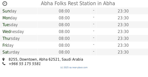
Abha Folks Rest Station
8255, Abha
Cafe
read more
1.974 km
ديوانية نسيم الجنوب
Abha
Cafe
read more
1.976 km
Coffee Ben Ali
7329 طريق الملك عبدالعزيز، العرين أبها 62524 2070 King Abdul Aziz Road, Abha
Cafe
read more
2.05 km
Sugar Donut
2539-2557 Al Imam Muhamed Ibn Saud, Abha
Cafe
read more
2.118 km
الارتقاء كافيه | Alertiqaa cafe
Abha
Cafe
read more
📑
all categories
Accounting
Administrative area level 1
Airport
Amusement park
Aquarium
Art gallery
Atm
Bakery
Bank
Bar
Beauty salon
Bicycle store
Book store
Bowling alley
Bus station
Cafe
Campground
Car dealer
Car rental
Car repair
Car wash
Casino
Cemetery
Church
City hall
Clothing store
Colloquial area
Convenience store
Country
Courthouse
Dentist
Department store
Doctor
Electrician
Electronics store
Embassy
Finance
Fire station
Florist
Food
Funeral home
Furniture store
Gas station
General contractor
Grocery or supermarket
Gym
Hair care
Hardware store
Health
Hindu Temple
Home goods store
Hospital
Insurance agency
Intersection
Jewelry store
Laundry
Lawyer
Library
Light rail station
Liquor store
Local government office
Locality
Locksmith
Lodging
Meal delivery
Meal takeaway
Mosque
Movie rental
Movie theater
Moving company
Museum
Natural feature
Neighborhood
Night club
Painter
Park
Parking
Pet store
Pharmacy
Physiotherapist
Place of worship
Plumber
Point of interest
Police
Political
Post office
Premise
Real estate agency
Restaurant
Roofing contractor
Route
Rv park, camping
School
Shoe store
Shopping mall
Spa
Stadium
Storage
Store
Sublocality
Subpremise
Subway station
Supermarket
Taxi stand
Train station
Transit station
Travel agency
University
Veterinary care
Zoo
sublocality level 1
↑