Cafe nearby Java Cafe
Saudi Arabia
Cafe nearby Java Cafe
Java Cafe
Al Imam Saud Ibn Faysal Road, 13315, Riyadh, SA Saudi Arabia
contacts phone
:
+966 9200 05282
Latitude:
24.7995559
, Longitude:
46.6451477
larger map & directions
read more
nearest Cafe
238 m
قهوجيين وصبابين بالرياض صبابين قهوة
8217 شارع الأمير سلمان بن محمد بن سعود، الصحافة، 3469، السعودية, Riyadh
Cafe
read more
301 m
دانة كافيه
3195 Imam Saud Bin Faisal Road, Riyadh
Cafe
read more
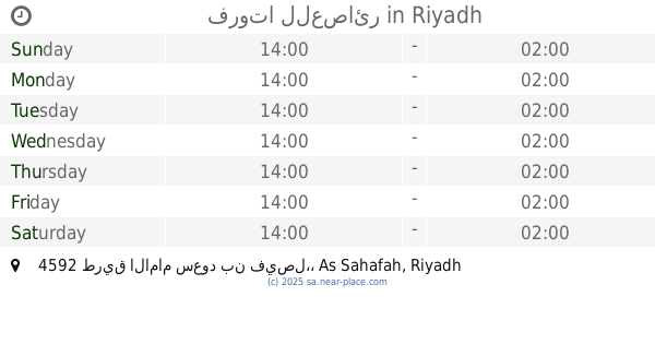
371 m
فروتا للعصائر
4592 طريق الامام سعود بن فيصل،, Riyadh
Cafe
read more
404 m
Dunkin' Donuts
Imam Saud Bin Faisal Road, Riyadh
Cafe
read more
495 m
Goodies sweet
Al Imam Saud Ibn Faysal Road, Riyadh
Cafe
read more
495 m
Goodies sweet
Imam Saud Bin Faisal Road, Riyadh
Cafe
read more
637 m
Original Coffee
Prince Salman Bin Mohammed Bin Saud, Riyadh
Cafe
read more
640 m
مقهى لوبالميير Lepalmier
4842 طريق الامام سعود بن فيصل، الصحافة، الرياض 13321
Cafe
read more
661 m
Le Palmire Cafe
4868 Al Imam Saud Ibn Faysal Road, 7018, Riyadh
Cafe
read more
727 m
Alchemy Coffee Roasters
4920 King Abdul Aziz Branch Road, 7043, Riyadh
Cafe
read more
813 m
Arab Moud
7732 Thumamah Street، الرياض
Cafe
read more
822 m
Moroccan Taste
King Abdul Aziz Branch Road, Riyadh
Cafe
read more
822 m
المذاق المغربي
King Abdul Aziz Branch Road, Riyadh
Cafe
read more
823 m
Arabicana Coffee
8406 King Abdul Aziz Road, Riyadh
Cafe
read more
825 m
Caribou cafe
6073, Riyadh
Cafe
read more
838 m
يوم الكنافة
الامير سلمان بن محمد بن سعود, Riyadh
Cafe
read more
839 m
PICO CAFÉ
Riyadh
Cafe
read more
839 m
Royal Cheese Cake Lounge
6173, Riyadh
Cafe
read more
855 m
بون قوت
6221 الياسمين، الرياض 13322
Cafe
read more
870 m
كيوبز كافية
Riyadh
Cafe
read more
873 m
LADINS
6271, Riyadh
Cafe
read more
873 m
Cubes Cafe
Riyadh
Cafe
read more
879 m
Deap your Drink
King Abdul Aziz Road, Riyadh
Cafe
read more
880 m
Delicieux Cafe
طريق الملك عبدالعزيز ,الربيع، الرياض
Cafe
read more
881 m
Java Cafe
7290 King Abdul Aziz Branch Rd, As Sahafah Riyadh 13321 4800 King Abdul Aziz Branch Road, Riyadh
Cafe
read more
📑
all categories
Accounting
Administrative area level 1
Airport
Amusement park
Aquarium
Art gallery
Atm
Bakery
Bank
Bar
Beauty salon
Bicycle store
Book store
Bowling alley
Bus station
Cafe
Campground
Car dealer
Car rental
Car repair
Car wash
Casino
Cemetery
Church
City hall
Clothing store
Colloquial area
Convenience store
Country
Courthouse
Dentist
Department store
Doctor
Electrician
Electronics store
Embassy
Finance
Fire station
Florist
Food
Funeral home
Furniture store
Gas station
General contractor
Grocery or supermarket
Gym
Hair care
Hardware store
Health
Hindu Temple
Home goods store
Hospital
Insurance agency
Intersection
Jewelry store
Laundry
Lawyer
Library
Light rail station
Liquor store
Local government office
Locality
Locksmith
Lodging
Meal delivery
Meal takeaway
Mosque
Movie rental
Movie theater
Moving company
Museum
Natural feature
Neighborhood
Night club
Painter
Park
Parking
Pet store
Pharmacy
Physiotherapist
Place of worship
Plumber
Point of interest
Police
Political
Post office
Premise
Real estate agency
Restaurant
Roofing contractor
Route
Rv park, camping
School
Shoe store
Shopping mall
Spa
Stadium
Storage
Store
Sublocality
Subpremise
Subway station
Supermarket
Taxi stand
Train station
Transit station
Travel agency
University
Veterinary care
Zoo
sublocality level 1
↑