Cafe nearby Java Cafe
Saudi Arabia
Cafe nearby Java Cafe
Java Cafe
عنيزة, الرياض, SA Saudiarabien
contacts phone
:
+966 9200 05282
website:
www.javacafe.com.sa
Latitude:
24.6960755
, Longitude:
46.7832006
larger map & directions
read more
nearest Cafe
206 m
Coffee Day
7646 Unayzah Street, Riyadh
Cafe
read more
291 m
ملحق اعيال
الروابي،, Riyadh
Cafe
read more
610 m
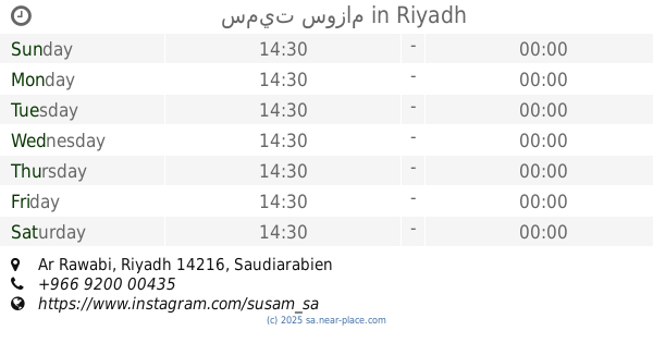
سميت سوزام
Riyadh
Cafe
read more
636 m
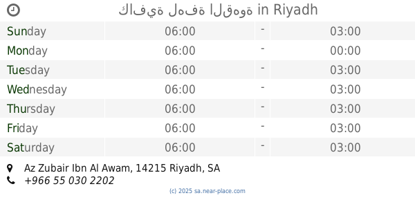
كافية لهفة القهوة
Az Zubair Ibn Al Awam, Riyadh
Cafe
read more
636 m
كافية لهفة القهوة
شارع الزبير بن العوام، الرياض
Cafe
read more
639 m
Presto Coffee & Tea
Riyadh
Cafe
read more
648 m
Cafe hankering COFFEE
شارع الزبير بن العوام، حي الروابي، الرياض
Cafe
read more
648 m
Cafe hankering COFFEE
Az Zubair Ibn Al Awam, Riyadh
Cafe
read more
683 m
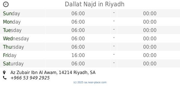
Dallat Najd
Az Zubair Ibn al Awwam, Riyadh
Cafe
read more
696 m
Dallat Najd
Az Zubair Ibn Al Awam, Riyadh
Cafe
read more
701 m
Coffen rural cafe
Az Zubair Ibn Al Awam, Riyadh
Cafe
read more
710 m
Wavy ice ويڤي آيس
Al Zubair Bin Al Awam Street, Riyadh
Cafe
read more
731 m
Golden Kangaroo cafe
Unayzah St Unayzah Street, 6724-, Riyadh
Cafe
read more
828 m
AlShalfan&Co
3570 Uthman Zadah, Riyadh
Cafe
read more
843 m
Rosa cafe
Riyadh
Cafe
read more
860 m
Hind sweet حلويات هند ❤️
Riyadh
Cafe
read more
866 m
كوبي للقهوة المختصة COBEE
Az Zubair Ibn Al Awam, Riyadh
Cafe
read more
972 m
Diamond Diamond Coffee
شارع الزبير بن العوام، حي الروابي، الرياض
Cafe
read more
980 m
Address Cafe
Ash Shaikh Abdul Rahman Ibn Saadi, Riyadh
Cafe
read more
982 m
House Of Donuts
مدخل أسواق العثيم،, Riyadh
Cafe
read more
998 m
Diamond Diamond Coffee
الزبير بن العوام Az Zubair Ibn Al Awam, Riyadh
Cafe
read more
1.02 km
Karak Address Cafe
Al-Imam Ahmad Bin Hanbal St, Ar Rayyan، الرياض
Cafe
read more
1.021 km
Roma Cafe
Unayzah St، الرياض
Cafe
read more
1.026 km
Hind’sweets
Az Zubair Ibn Al Awam, Riyadh
Cafe
read more
1.039 km
Java Cafe
Eastern Ring Branch Road, Riyadh
Cafe
read more
📑
all categories
Accounting
Administrative area level 1
Airport
Amusement park
Aquarium
Art gallery
Atm
Bakery
Bank
Bar
Beauty salon
Bicycle store
Book store
Bowling alley
Bus station
Cafe
Campground
Car dealer
Car rental
Car repair
Car wash
Casino
Cemetery
Church
City hall
Clothing store
Colloquial area
Convenience store
Country
Courthouse
Dentist
Department store
Doctor
Electrician
Electronics store
Embassy
Finance
Fire station
Florist
Food
Funeral home
Furniture store
Gas station
General contractor
Grocery or supermarket
Gym
Hair care
Hardware store
Health
Hindu Temple
Home goods store
Hospital
Insurance agency
Intersection
Jewelry store
Laundry
Lawyer
Library
Light rail station
Liquor store
Local government office
Locality
Locksmith
Lodging
Meal delivery
Meal takeaway
Mosque
Movie rental
Movie theater
Moving company
Museum
Natural feature
Neighborhood
Night club
Painter
Park
Parking
Pet store
Pharmacy
Physiotherapist
Place of worship
Plumber
Point of interest
Police
Political
Post office
Premise
Real estate agency
Restaurant
Roofing contractor
Route
Rv park, camping
School
Shoe store
Shopping mall
Spa
Stadium
Storage
Store
Sublocality
Subpremise
Subway station
Supermarket
Taxi stand
Train station
Transit station
Travel agency
University
Veterinary care
Zoo
sublocality level 1
↑