Cafe nearby كافتيريا الخليج العربي
Saudi Arabia
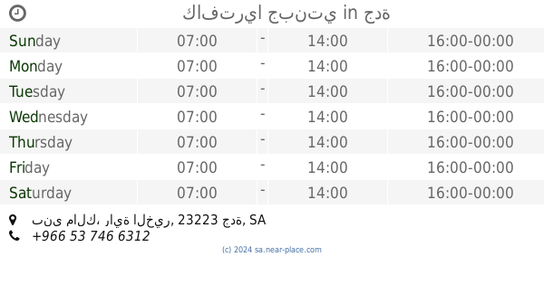
Cafe nearby كافتيريا الخليج العربي
كافتيريا الخليج العربي
ابو حسان البصري, Jeddah Saudi Arabia
contacts phone
:
+966
Latitude:
21.5277582
, Longitude:
39.2117708
read more
nearest Cafe
2 m
Egyptian Coffee
ابو حسان البصري, Jeddah
Cafe
read more
144 m
كفتيريا عدن
شارع السبعين، بني مالك، جدة
Cafe
read more
147 m
كافتريا الجزيرة . قهوة مصرين
2329 ابو حسان البصري, Jeddah
Cafe
read more
305 m
سانتوسکیفے پرنس ماجد جدہ
Unnamed Road, Jeddah
Cafe
read more
332 m
كافتريا ليالينا
الأمير ماجد، بني مالك، جدة
Cafe
read more
430 m
دهب كافية
Jeddah
Cafe
read more
432 m
Moroccan Taste
حي بني مالك، جدة
Cafe
read more
432 m
Moroccan Taste
Bani Malik, Jeddah
Cafe
read more
441 m
افو كادو
Jeddah
Cafe
read more
455 m
الديوانية
Jeddah
Cafe
read more
536 m
مقهي الربيع
Unnamed Road, Jeddah
Cafe
read more
795 m
دهب كافية
بني مالك،, Jeddah
Cafe
read more
905 m
Gourmet sweet
8229, Bani Malik District, Jeddah
Cafe
read more
945 m
قهوة بني مالك
2959 هشام بن عامر, حي بنى مالك،, Jeddah
Cafe
read more
950 m
Farah's Cafe
2959 هشام بن عامر, Bani Malik District,, Jeddah
Cafe
read more
997 m
Karak Cafe
6211، الصحافه،، Mishrifah District، Jeddah، 23341، 3123
Cafe
read more
1.184 km
Judy Cafe
Al Urubah, Jeddah
Cafe
read more
1.185 km
Moroccan taste
الورود،, Jeddah
Cafe
read more
1.193 km
Joudy Cafe
Al Urubah Street, Jeddah
Cafe
read more
1.252 km
قهوة الكتيابي بني مالك
Unnamed Road, Jeddah
Cafe
read more
1.256 km
Cafe Thoughts
طريق الامير متعب بن عبدالعزيز Prince Mutaib bin Abdulaziz Road, حي مشرفة, Jeddah
Cafe
read more
1.272 km
كافتريا جبنتي
بني مالك، راية الخير، جدة
Cafe
read more
1.28 km
بلاتينيا كافيه
4840 Falastin, حي مشرفة, Jeddah
Cafe
read more
1.282 km
كافتريا جبنتي
حي بني مالك، جدة
Cafe
read more
1.283 km
Al Asala Diwaniah ديوانية الأصالة
Jeddah
Cafe
read more
📑
all categories
Accounting
Administrative area level 1
Airport
Amusement park
Aquarium
Art gallery
Atm
Bakery
Bank
Bar
Beauty salon
Bicycle store
Book store
Bowling alley
Bus station
Cafe
Campground
Car dealer
Car rental
Car repair
Car wash
Casino
Cemetery
Church
City hall
Clothing store
Colloquial area
Convenience store
Country
Courthouse
Dentist
Department store
Doctor
Electrician
Electronics store
Embassy
Finance
Fire station
Florist
Food
Funeral home
Furniture store
Gas station
General contractor
Grocery or supermarket
Gym
Hair care
Hardware store
Health
Hindu Temple
Home goods store
Hospital
Insurance agency
Intersection
Jewelry store
Laundry
Lawyer
Library
Light rail station
Liquor store
Local government office
Locality
Locksmith
Lodging
Meal delivery
Meal takeaway
Mosque
Movie rental
Movie theater
Moving company
Museum
Natural feature
Neighborhood
Night club
Painter
Park
Parking
Pet store
Pharmacy
Physiotherapist
Place of worship
Plumber
Point of interest
Police
Political
Post office
Premise
Real estate agency
Restaurant
Roofing contractor
Route
Rv park, camping
School
Shoe store
Shopping mall
Spa
Stadium
Storage
Store
Sublocality
Subpremise
Subway station
Supermarket
Taxi stand
Train station
Transit station
Travel agency
University
Veterinary care
Zoo
sublocality level 1
↑