Cafe nearby Krispy Kreme
Saudi Arabia
Cafe nearby Krispy Kreme
Krispy Kreme
Dammam Branch Road, 13242, Riyadh, SA Saudi Arabia
contacts phone
:
+966
website:
www.krispykrememe.com
Latitude:
24.8009319
, Longitude:
46.7437237
larger map & directions
read more
nearest Cafe
9 m
Krispy Kreme
Damam Road & Khalid Bin Waleed St.، الرياض
Cafe
read more
335 m
Al Dallah Al Shathliah
3428 Dammam Branch Road, Riyadh
Cafe
read more
335 m
Al Dallah Al Shathliah
3428 طريق الدمام الفرعي، الرياض
Cafe
read more
440 m
Dunkin' Donuts
3747 Dammam Branch Road, Riyadh
Cafe
read more
445 m
زهرة الفنار
Unnamed Road, Riyadh
Cafe
read more
609 m
DR.CAFE COFFEE
Qurtubah, Riyadh
Cafe
read more
654 m
عالمي الخاص
Dammam Branch Road, Riyadh
Cafe
read more
786 m
Tim Hortons
3049 Dammam Branch Road, Riyadh
Cafe
read more
819 m
كوفي إيسنس
طريق سعيد ابن زيد، حي قرطبة، الرياض
Cafe
read more
827 m
دلة الطيبين
Dammam Road, Riyadh
Cafe
read more
850 m
Coffee lights
قرطبة طريق سعيد ابن زيد،، الرياض
Cafe
read more
851 m
Moroccan mood
3928 طريق الدمام الفرعي، الرياض
Cafe
read more
854 m
Moroccan mood
3928 Dammam Branch Road, Riyadh
Cafe
read more
940 m
محامص ومكسرات
شارع بعلبك، حي غرناطة، الرياض
Cafe
read more
981 m
Edible arrangments
Riyadh
Cafe
read more
1.047 km
Coffee Day
طريق سعيد بن زيد، حي قرطبة، الرياض
Cafe
read more
1.138 km
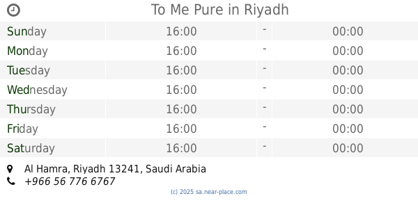
To Me Pure
Riyadh
Cafe
read more
1.177 km
رنوش
محمد علي جناح، الشهداء، الرياض
Cafe
read more
1.182 km
الضوء القادم
وادي اللجام, Riyadh
Cafe
read more
1.184 km
اشجان فيروز كافيه
Abi Jafar Al Mansur, Riyadh
Cafe
read more
1.187 km
اشجان فيروز كافية
Riyadh
Cafe
read more
1.195 km
مقهى الاعلاميين
Riyadh
Cafe
read more
1.196 km
كريب الشرق فرع غرناطه
Muhammad ali Junah, Riyadh
Cafe
read more
1.234 km
اشجان فيروز
محمد علي جناح، الشهداء، الرياض
Cafe
read more
1.24 km
Coffee Stamp
Riyadh
Cafe
read more
📑
all categories
Accounting
Administrative area level 1
Airport
Amusement park
Aquarium
Art gallery
Atm
Bakery
Bank
Bar
Beauty salon
Bicycle store
Book store
Bowling alley
Bus station
Cafe
Campground
Car dealer
Car rental
Car repair
Car wash
Casino
Cemetery
Church
City hall
Clothing store
Colloquial area
Convenience store
Country
Courthouse
Dentist
Department store
Doctor
Electrician
Electronics store
Embassy
Finance
Fire station
Florist
Food
Funeral home
Furniture store
Gas station
General contractor
Grocery or supermarket
Gym
Hair care
Hardware store
Health
Hindu Temple
Home goods store
Hospital
Insurance agency
Intersection
Jewelry store
Laundry
Lawyer
Library
Light rail station
Liquor store
Local government office
Locality
Locksmith
Lodging
Meal delivery
Meal takeaway
Mosque
Movie rental
Movie theater
Moving company
Museum
Natural feature
Neighborhood
Night club
Painter
Park
Parking
Pet store
Pharmacy
Physiotherapist
Place of worship
Plumber
Point of interest
Police
Political
Post office
Premise
Real estate agency
Restaurant
Roofing contractor
Route
Rv park, camping
School
Shoe store
Shopping mall
Spa
Stadium
Storage
Store
Sublocality
Subpremise
Subway station
Supermarket
Taxi stand
Train station
Transit station
Travel agency
University
Veterinary care
Zoo
sublocality level 1
↑