Cafe nearby كوفي ومطعم ميم إليفين
Saudi Arabia
Cafe nearby كوفي ومطعم ميم إليفين
كوفي ومطعم ميم إليفين
8546 الواحة،، Al Wahah, Jeddah 23354 3563, Saudi Arabia
contacts phone
:
+966 12 605 9755
website:
d2020.net
Latitude:
21.5630366
, Longitude:
39.2460307
larger map & directions
read more
nearest Cafe
30 m
ديوانية زفن -كافيه
Jeddah
Cafe
read more
57 m
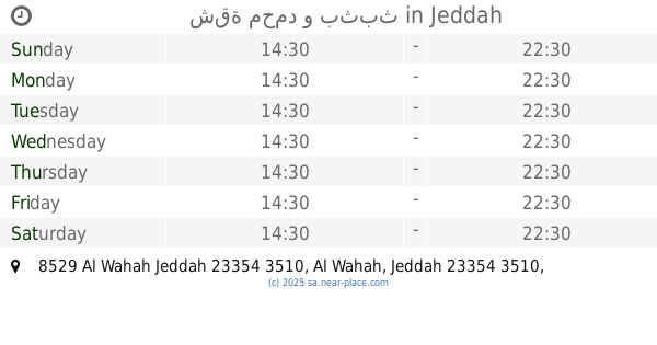
شقة محمد و بثبث
8529 Al Wahah Jeddah 23354 3510
Cafe
read more
75 m
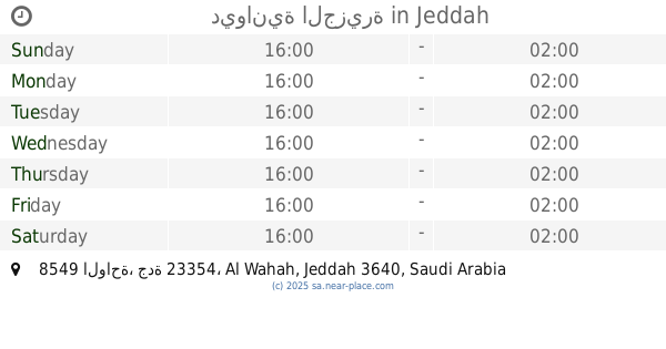
ديوانية الجزيرة
8549 الواحة، جدة 23354
Cafe
read more
310 m
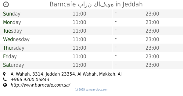
بارن كافيه
حي الشروق، جدة
Cafe
read more
321 m
Barncafe بارن كافيه
Al Wahah, 3314, Jeddah 23354, Makkah, Al Wahah, Jeddah
Cafe
read more
698 m
سانتوس Santos
Jeddah
Cafe
read more
861 m
Man
Unnamed Road, Jeddah
Cafe
read more
1.385 km
سوزان السعيد
2777 احمد بن محمد العشاب،, 7414, Jeddah
Cafe
read more
1.493 km
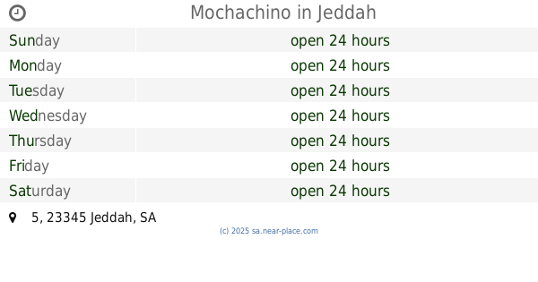
Mochachino
5, Jeddah
Cafe
read more
1.52 km
Am assaggaf
8920 Ring Rd Express Way AR Rihab District Jeddah 23345
Cafe
read more
1.52 km
Burjar arabi aman
Unnamed Road, Jeddah
Cafe
read more
1.696 km
Mochachino JM-06
الرحاب، جدة
Cafe
read more
1.698 km
Mochachino JM-06
Jeddah
Cafe
read more
1.892 km
Mochachino
Jeddah
Cafe
read more
2.049 km
وافل هوم
Jeddah
Cafe
read more
2.052 km
ديوانية الأمراء
شارع الحسين السهواجي، حي السامر، جدة
Cafe
read more
2.091 km
قهوتي
حي الصفا، جدة
Cafe
read more
2.115 km
ديوانية الدلة البغدادية
2596, As Samir District, Jeddah
Cafe
read more
2.153 km
خوش كرك
Al Samer, Opp. NCB ATM, Al Samer Dist.، جدة
Cafe
read more
2.234 km
مقهى لمسات
Prince Mohammed Bin Abdulaziz Street, Jeddah
Cafe
read more
2.24 km
Coffee
Alhusain Alsouhwagi, Jeddah
Cafe
read more
2.242 km
القهوة الحديثة
Jeddah
Cafe
read more
2.263 km
ديوانية المكارم
Alhusain Alsouhwagi, Jeddah
Cafe
read more
2.316 km
قافلة القهوة
King Fahd Road, Jeddah
Cafe
read more
2.351 km
Dose Of Joy
Jeddah
Cafe
read more
📑
all categories
Accounting
Administrative area level 1
Airport
Amusement park
Aquarium
Art gallery
Atm
Bakery
Bank
Bar
Beauty salon
Bicycle store
Book store
Bowling alley
Bus station
Cafe
Campground
Car dealer
Car rental
Car repair
Car wash
Casino
Cemetery
Church
City hall
Clothing store
Colloquial area
Convenience store
Country
Courthouse
Dentist
Department store
Doctor
Electrician
Electronics store
Embassy
Finance
Fire station
Florist
Food
Funeral home
Furniture store
Gas station
General contractor
Grocery or supermarket
Gym
Hair care
Hardware store
Health
Hindu Temple
Home goods store
Hospital
Insurance agency
Intersection
Jewelry store
Laundry
Lawyer
Library
Light rail station
Liquor store
Local government office
Locality
Locksmith
Lodging
Meal delivery
Meal takeaway
Mosque
Movie rental
Movie theater
Moving company
Museum
Natural feature
Neighborhood
Night club
Painter
Park
Parking
Pet store
Pharmacy
Physiotherapist
Place of worship
Plumber
Point of interest
Police
Political
Post office
Premise
Real estate agency
Restaurant
Roofing contractor
Route
Rv park, camping
School
Shoe store
Shopping mall
Spa
Stadium
Storage
Store
Sublocality
Subpremise
Subway station
Supermarket
Taxi stand
Train station
Transit station
Travel agency
University
Veterinary care
Zoo
sublocality level 1
↑