Cafe nearby ماما روتي كافيه
Saudi Arabia
Cafe nearby ماما روتي كافيه
ماما روتي كافيه
Alrayan, Buraydah 52379, Saudi Arabia
contacts phone
:
+966 11 406 1119
website:
mammaroti.com.sa
Latitude:
26.411186
, Longitude:
43.9172365
larger map & directions
read more
nearest Cafe
224 m
عزيز cafe
Umar Ibn Al Khatab Road, Buraydah
Cafe
read more
255 m
Customized Coffee Truck
Unnamed Road, Buraydah
Cafe
read more
649 m
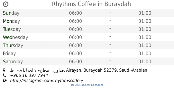
Rhythms Coffee
طريق الريان مخطط الرواف, Buraydah
Cafe
read more
661 m
Canto Specialty Coffee
شارع البخاري, Buraydah
Cafe
read more
666 m
كانتو Canto
شارع البخاري،، بريدة
Cafe
read more
688 m
Levanti Cafe
شارع البخاري, Buraydah
Cafe
read more
740 m
بارستا
Uthman Ibn Affan Road, Buraydah
Cafe
read more
748 m
Ripple cafe
2940 Uthman Ibn Affan Road, Buraydah
Cafe
read more
750 m
Dunkin Donuts
2877 Uthman Ibn Affan Road, Buraydah
Cafe
read more
764 m
AURELIA Speclalty Coffee
Buraydah
Cafe
read more
770 m
كانيل Canelle
Buraydah
Cafe
read more
772 m
AURELIA SPECIALITY COOFFEE
Buraydah
Cafe
read more
798 m
Gloria Jeans | جلوريا جينز
Buraydah
Cafe
read more
799 m
قولدن قست كفي Golden Guest Cafe
2892 Uthman Ibn Affan Road, Al Rawaf Planning, Buraydah
Cafe
read more
953 m
Le Churro Station
شارع البخاري, Buraydah
Cafe
read more
961 m
مجالس الفرسان للقهوة العربية
3117, مخطط الرواف، 8250, Buraydah
Cafe
read more
993 m
Cherry Rose
Buraydah
Cafe
read more
1.013 km
جاما كافيه
Buraydah
Cafe
read more
1.112 km
Bash Coffee
3261 Uthman Ibn Affan Road, Al Rawaf Planning, Buraydah
Cafe
read more
1.122 km
كيك وكافيه لوز
شارع البخاري, Buraydah
Cafe
read more
1.143 km
كب كوكيز
Uthman Ibn Affan Road, Buraydah
Cafe
read more
1.177 km
غلوريا جينز كوفيز
شارع البخاري ، حي الريان، بريدة
Cafe
read more
1.192 km
Gloria Jean's Coffees
شارع البخاري, Buraydah
Cafe
read more
1.39 km
Dip in Paris
Umar Ibn Al Khatab Road, Buraydah
Cafe
read more
1.403 km
مجموعة دار كيف كافية
Buraydah
Cafe
read more
📑
all categories
Accounting
Administrative area level 1
Airport
Amusement park
Aquarium
Art gallery
Atm
Bakery
Bank
Bar
Beauty salon
Bicycle store
Book store
Bowling alley
Bus station
Cafe
Campground
Car dealer
Car rental
Car repair
Car wash
Casino
Cemetery
Church
City hall
Clothing store
Colloquial area
Convenience store
Country
Courthouse
Dentist
Department store
Doctor
Electrician
Electronics store
Embassy
Finance
Fire station
Florist
Food
Funeral home
Furniture store
Gas station
General contractor
Grocery or supermarket
Gym
Hair care
Hardware store
Health
Hindu Temple
Home goods store
Hospital
Insurance agency
Intersection
Jewelry store
Laundry
Lawyer
Library
Light rail station
Liquor store
Local government office
Locality
Locksmith
Lodging
Meal delivery
Meal takeaway
Mosque
Movie rental
Movie theater
Moving company
Museum
Natural feature
Neighborhood
Night club
Painter
Park
Parking
Pet store
Pharmacy
Physiotherapist
Place of worship
Plumber
Point of interest
Police
Political
Post office
Premise
Real estate agency
Restaurant
Roofing contractor
Route
Rv park, camping
School
Shoe store
Shopping mall
Spa
Stadium
Storage
Store
Sublocality
Subpremise
Subway station
Supermarket
Taxi stand
Train station
Transit station
Travel agency
University
Veterinary care
Zoo
sublocality level 1
↑