Cafe nearby مجالس العرب 0570003535
Coronavirus disease (COVID-19) Situation
confirmed cases
841469
deaths
9646
Saudi Arabia
Cafe nearby مجالس العرب 0570003535
مجالس العرب 0570003535
Al Mathnah, Khamis Mushait 62461, Saudi Arabia
contacts phone
:
+966 57 000 3535
Latitude:
18.2898831
, Longitude:
42.7318939
larger map & directions
read more
nearest Cafe
360 m
سكري للتمور
Khamis Mushait
Cafe
read more
396 m
قهوةدليم بيت القهوة العربية
King Khalid Road, Khamis Mushait
Cafe
read more
684 m
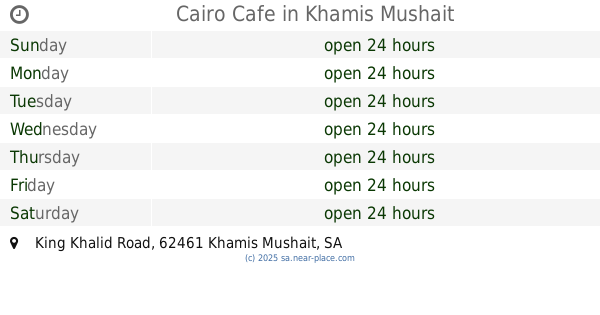
Cairo Cafe
King Khalid Road, Khamis Mushait
Cafe
read more
691 m
ديربي كافيه
Khamis Mushait
Cafe
read more
696 m
نواة للقهوة المختصة
Khamis Mushait
Cafe
read more
741 m
مقهى فندق بيات
السد،, Khamis Mushait
Cafe
read more
817 m
ماما كيك - اسر منتجه
Khamis Mushait
Cafe
read more
850 m
The horse carriage
Khamis Mushait
Cafe
read more
850 m
Horse Carriage Speciality Coffee
Khamis Mushait
Cafe
read more
852 m
Horse Carriage Speciality Coffee عربة الفرس
طريق الأمير سلطان، خميس مشيط
Cafe
read more
859 m
Horse Carriage Speciality Coffee
Cafe
read more
947 m
Horse Carriage Speciality Coffee
طريق الأمير سلطان، خميس مشيط
Cafe
read more
1.034 km
Al Noor Coffee مقهى النور
Khamis Mushait
Cafe
read more
1.038 km
كريب & كوفي
Khamis Mushait
Cafe
read more
1.158 km
Memory Coffee
ام سرار،، خميس مشيط
Cafe
read more
1.285 km
مهيلة الشموخ للقهوه العربيه
3249 Alyah, Khamis Mushait
Cafe
read more
1.293 km
مهيلة الشموخ
3271 شارع الأمير سلطان، مخطط بن مشيط، عليا، خميس مشيط
Cafe
read more
1.338 km
ميموري كافية
Khamis Mushait
Cafe
read more
1.373 km
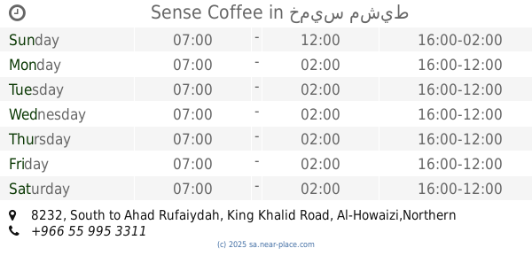
Sense Coffee
8232 South to Ahad Rufaiydah, King Khalid Road, Al-Howaizi,Northern to Khamis Mushayt، خميس مشيط
Cafe
read more
1.389 km
dunkin donuts
Prince Sultan Road, Khamis Mushait
Cafe
read more
1.437 km
قهوه التاسعه
Khamis Mushait
Cafe
read more
1.442 km
القهوة التاسعه
Khamis Mushait
Cafe
read more
1.443 km
جافا ديتور
الامير سلطان، خميس مشيط
Cafe
read more
1.465 km
Nesma Cafe
Unnamed Road, Khamis Mushait
Cafe
read more
1.475 km
كلاسيك كافيه
الملك سعود، الفتح،،, Khamis Mushait
Cafe
read more
📑
all categories
Accounting
Administrative area level 1
Airport
Amusement park
Aquarium
Art gallery
Atm
Bakery
Bank
Bar
Beauty salon
Bicycle store
Book store
Bowling alley
Bus station
Cafe
Campground
Car dealer
Car rental
Car repair
Car wash
Casino
Cemetery
Church
City hall
Clothing store
Colloquial area
Convenience store
Country
Courthouse
Dentist
Department store
Doctor
Electrician
Electronics store
Embassy
Finance
Fire station
Florist
Food
Funeral home
Furniture store
Gas station
General contractor
Grocery or supermarket
Gym
Hair care
Hardware store
Health
Hindu Temple
Home goods store
Hospital
Insurance agency
Intersection
Jewelry store
Laundry
Lawyer
Library
Light rail station
Liquor store
Local government office
Locality
Locksmith
Lodging
Meal delivery
Meal takeaway
Mosque
Movie rental
Movie theater
Moving company
Museum
Natural feature
Neighborhood
Night club
Painter
Park
Parking
Pet store
Pharmacy
Physiotherapist
Place of worship
Plumber
Point of interest
Police
Political
Post office
Premise
Real estate agency
Restaurant
Roofing contractor
Route
Rv park, camping
School
Shoe store
Shopping mall
Spa
Stadium
Storage
Store
Sublocality
Subpremise
Subway station
Supermarket
Taxi stand
Train station
Transit station
Travel agency
University
Veterinary care
Zoo
sublocality level 1
↑