Cafe nearby Moon Cafe
Saudi Arabia
Cafe nearby Moon Cafe
Moon Cafe
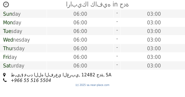
Prince Muqrin Ibn Abdulaziz Street, 13216, Riyadh, SA Saudi Arabia
contacts phone
:
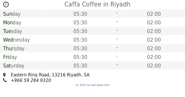
+966 53 722 6688
Latitude:
24.767134
, Longitude:
46.7357782
larger map & directions
read more
nearest Cafe
154 m
أرابيكا
Eastern Ring Branch Road, Riyadh
Cafe
read more
154 m
Arabica Cafe
7331 Eastern Ring Branch Road, Riyadh
Cafe
read more
210 m
Domestic coffee
2713 Prince Muqrin Ibn Abdulaziz Street, Riyadh
Cafe
read more
422 m
Caffa Coffee
Eastern Ring Road, Riyadh
Cafe
read more
728 m
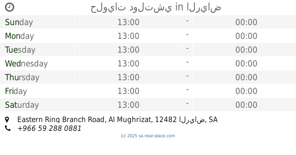
حلويات دولتشي
Eastern Ring Branch Road, Al Mughrizat، الرياض
Cafe
read more
786 m
Gold & Glow
Unnamed Road, Riyadh
Cafe
read more
821 m
شوشار كافيه
2884 Prince Muqrin Ibn Abdulaziz Street, Riyadh
Cafe
read more
854 m
Sweet point
Unnamed Road, Riyadh
Cafe
read more
858 m
storia cafe
Unnamed Road, Riyadh
Cafe
read more
858 m
يموقي كريب
Riyadh
Cafe
read more
859 m
يموقي
حديقة الحمراء, Al Hamra Trail, Riyadh
Cafe
read more
865 m
كرك وچباتي كافيه
Riyadh
Cafe
read more
872 m
Riyadh Coffee Truck
Riyadh
Cafe
read more
872 m
سويت ستريت
Riyadh
Cafe
read more
901 m
فيروز كافية
2143 King Abdullah Ibn Abdul Aziz Road, Riyadh
Cafe
read more
901 m
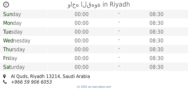
واجه القهوة
Riyadh
Cafe
read more
901 m
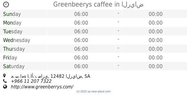
Greenbeerys caffee
مسلمة الأنصاري، الرياض
Cafe
read more
901 m
Friends Cafe
King Abdullah Branch Road, Riyadh
Cafe
read more
903 m
ميت ذا كوفي
2143 طريق الملك عبدالله بن عبدالعزيز، القدس الرياض 13214
Cafe
read more
910 m
اورانج مق
King Abdullah Branch Road, Riyadh
Cafe
read more
921 m
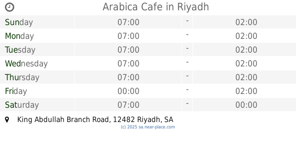
ارابيكا كافيه
طريق عبد الله الفرعي الغربي، جدة
Cafe
read more
930 m
Interface Coffee
7767 Eastern Ring Branch Road, Riyadh
Cafe
read more
936 m
Arabica Cafe
King Abdullah Branch Road, Riyadh
Cafe
read more
997 m
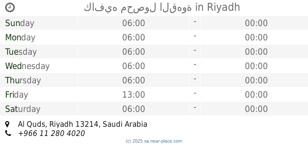
كافيه محصول القهوة
Riyadh
Cafe
read more
1.066 km
Doppio caffe
Al Quds, King Abdullah Road، الرياض
Cafe
read more
📑
all categories
Accounting
Administrative area level 1
Airport
Amusement park
Aquarium
Art gallery
Atm
Bakery
Bank
Bar
Beauty salon
Bicycle store
Book store
Bowling alley
Bus station
Cafe
Campground
Car dealer
Car rental
Car repair
Car wash
Casino
Cemetery
Church
City hall
Clothing store
Colloquial area
Convenience store
Country
Courthouse
Dentist
Department store
Doctor
Electrician
Electronics store
Embassy
Finance
Fire station
Florist
Food
Funeral home
Furniture store
Gas station
General contractor
Grocery or supermarket
Gym
Hair care
Hardware store
Health
Hindu Temple
Home goods store
Hospital
Insurance agency
Intersection
Jewelry store
Laundry
Lawyer
Library
Light rail station
Liquor store
Local government office
Locality
Locksmith
Lodging
Meal delivery
Meal takeaway
Mosque
Movie rental
Movie theater
Moving company
Museum
Natural feature
Neighborhood
Night club
Painter
Park
Parking
Pet store
Pharmacy
Physiotherapist
Place of worship
Plumber
Point of interest
Police
Political
Post office
Premise
Real estate agency
Restaurant
Roofing contractor
Route
Rv park, camping
School
Shoe store
Shopping mall
Spa
Stadium
Storage
Store
Sublocality
Subpremise
Subway station
Supermarket
Taxi stand
Train station
Transit station
Travel agency
University
Veterinary care
Zoo
sublocality level 1
↑