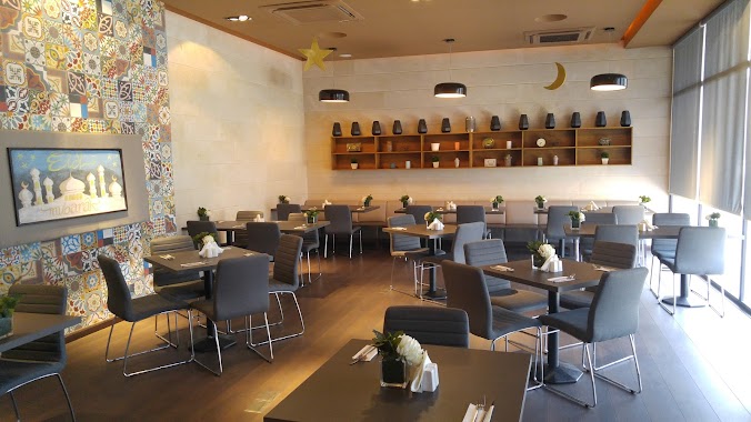
Cafe nearby مقهى قلعة القطيف
Coronavirus disease (COVID-19) Situation
confirmed cases
841469
deaths
9646
Saudi Arabia
Cafe nearby مقهى قلعة القطيف
مقهى قلعة القطيف
Bab As Sab, Al Qatif 32637, Saudi Arabia
contacts phone
:
+966
Latitude:
26.5663584
, Longitude:
50.0019904
larger map & directions
read more
nearest Cafe
312 m
Downtown Cafe
Uhud Road, Al Qatif
Cafe
read more
380 m
قطعة الشوكولاته
شارع الإمام الحسين،، القطيف
Cafe
read more
439 m
FrozenCups Yogurt & Café | مقهى فروزن كبز
Uhud Road, Al Qatif
Cafe
read more
509 m
Saadeddin Pastry
3448 Uhud Road, Al Qatif
Cafe
read more
560 m
Bergamo Ombrello Caffe
Uhud Road, Al Qatif
Cafe
read more
850 m
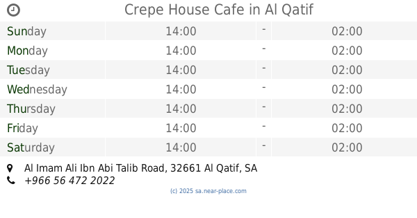
Crepe House Cafe
Al Imam Ali Ibn Abi Talib Road, Al Qatif
Cafe
read more
887 m
مقهى وردة الجوري
Uhud Road, Al Qatif
Cafe
read more
906 m
My Little Pan
Al Jazirah Street, Al Qatif
Cafe
read more
907 m
Time out cafe
Al Jazirah Street, Al Qatif
Cafe
read more
910 m
Time Out Café
7939 Al Jazirah Street, Al Qatif
Cafe
read more
927 m
La Roseeta Cafe
القطيف, Al Jubayl
Cafe
read more
955 m
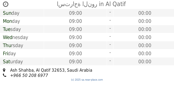
استراحة النور
Al Qatif
Cafe
read more
1.078 km
Rawabi sweet
Al Qatif
Cafe
read more
1.119 km
Raven Coffee
7237 King Abdulaziz Road, Al Qatif
Cafe
read more
1.119 km
EasTcan Cafe
Al Quds Street, Al Qatif
Cafe
read more
1.277 km
Awtar Rialto
Al Qatif
Cafe
read more
1.313 km
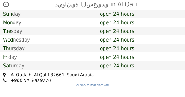
ديوانية السعيدي
Al Qatif
Cafe
read more
1.313 km
Frozen yogurt
Al Qatif
Cafe
read more
1.333 km
كراج ملازم اول
Al Qatif
Cafe
read more
1.389 km
Derby Int'l Coffee
Uhud Road, Al Qatif
Cafe
read more
1.399 km
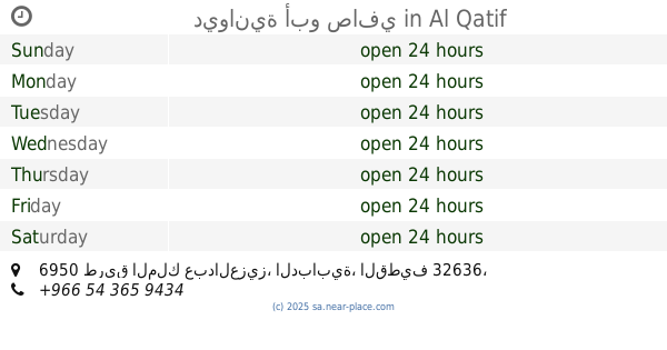
ديوانية أبو صافي
6950 طريق الملك عبدالعزيز، الدبابية، القطيف 32636
Cafe
read more
1.439 km
كوين بيكر
Unnamed Road, Al Qatif
Cafe
read more
1.446 km
Anamely Store
3900, Al Qatif
Cafe
read more
1.486 km
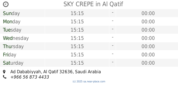
SKY CREPE
Al Qatif
Cafe
read more
1.646 km
ديوانية الشماسي
Unnamed Road, Al Qatif
Cafe
read more
📑
all categories
Accounting
Administrative area level 1
Airport
Amusement park
Aquarium
Art gallery
Atm
Bakery
Bank
Bar
Beauty salon
Bicycle store
Book store
Bowling alley
Bus station
Cafe
Campground
Car dealer
Car rental
Car repair
Car wash
Casino
Cemetery
Church
City hall
Clothing store
Colloquial area
Convenience store
Country
Courthouse
Dentist
Department store
Doctor
Electrician
Electronics store
Embassy
Finance
Fire station
Florist
Food
Funeral home
Furniture store
Gas station
General contractor
Grocery or supermarket
Gym
Hair care
Hardware store
Health
Hindu Temple
Home goods store
Hospital
Insurance agency
Intersection
Jewelry store
Laundry
Lawyer
Library
Light rail station
Liquor store
Local government office
Locality
Locksmith
Lodging
Meal delivery
Meal takeaway
Mosque
Movie rental
Movie theater
Moving company
Museum
Natural feature
Neighborhood
Night club
Painter
Park
Parking
Pet store
Pharmacy
Physiotherapist
Place of worship
Plumber
Point of interest
Police
Political
Post office
Premise
Real estate agency
Restaurant
Roofing contractor
Route
Rv park, camping
School
Shoe store
Shopping mall
Spa
Stadium
Storage
Store
Sublocality
Subpremise
Subway station
Supermarket
Taxi stand
Train station
Transit station
Travel agency
University
Veterinary care
Zoo
sublocality level 1
↑