Cafe nearby معسلات الكيف الراقي
Saudi Arabia
Cafe nearby معسلات الكيف الراقي
معسلات الكيف الراقي
شارع،, وهيب بن عمير، السامر، جدة السعودية, Jeddah Saudi Arabia
contacts phone
:
+966
Latitude:
21.5903577
, Longitude:
39.2373095
read more
nearest Cafe
311 m
Barncafe بارن كافيه
AL SAMIR STREET AT AL SAMIR GAZ STATION, Jeddah, AL-SAMER, حي السامر - محطة المواريد, فرع السامر, Jeddah
Cafe
read more
320 m
Almaqsaf Cafeteria
Al Samer, Jeddah
Cafe
read more
352 m
كرك الخليج
جدة
Cafe
read more
484 m
Diwaniya origins of coffee
Ankara, Jeddah
Cafe
read more
489 m
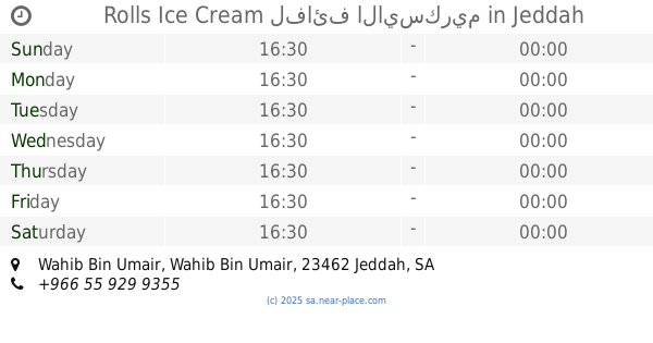
Rolls Ice Cream لفائف الايسكريم
Wahib Bin Umair Wahib Bin Umair, Al Manar District, Jeddah
Cafe
read more
559 m
Laziz Burger Samir
6272-6378 Wahib Bin Umair, Jeddah
Cafe
read more
560 m
Ice Cream Shop
6583 عمر بن قيس, Jeddah
Cafe
read more
694 m
مركاز القهوة
عبدالله بن عطاء, Jeddah
Cafe
read more
712 m
meerkaz cafe
Jeddah
Cafe
read more
715 m
ايس جولي
Wahib Bin Umair, Jeddah
Cafe
read more
748 m
LE Churro
Al Samer, Jeddah
Cafe
read more
832 m
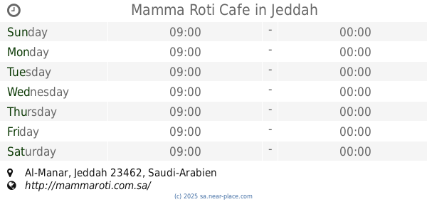
Mamma Roti Cafe
Jeddah
Cafe
read more
848 m
Seattle's Best Coffee
3124 الطريق الدائري, Al Manar District, Jeddah
Cafe
read more
858 m
PAUL
شارع الاجواد ، حي المنار، جدة
Cafe
read more
858 m
shakr factor
المنار،, Jeddah
Cafe
read more
945 m
دربي كافية
Jeddah
Cafe
read more
964 m
نيسبريسو
Jeddah
Cafe
read more
970 m
شاي أبو لتين الغامدي
6535 الطريق الدائري، حي السامر جدة 23462
Cafe
read more
989 m
Wetzel's Pretzels
Yasmin Mall, Jeddah
Cafe
read more
992 m
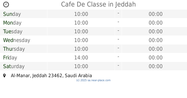
Cafe De Classe
Jeddah
Cafe
read more
1.032 km
خوش كرك
Al Samer, Opp. NCB ATM, Al Samer Dist.، جدة
Cafe
read more
1.061 km
Kahve Dünyası
Jeddah
Cafe
read more
1.078 km
Kamps The German Bäckerei
Jeddah
Cafe
read more
1.086 km
ربوة الخميس
2278 Arramih Almuri, As Samir District Jeddah 23461 7612 Arramih Almuri, Jeddah
Cafe
read more
1.087 km
مقهى القهوة ذوق
Jeddah
Cafe
read more
📑
all categories
Accounting
Administrative area level 1
Airport
Amusement park
Aquarium
Art gallery
Atm
Bakery
Bank
Bar
Beauty salon
Bicycle store
Book store
Bowling alley
Bus station
Cafe
Campground
Car dealer
Car rental
Car repair
Car wash
Casino
Cemetery
Church
City hall
Clothing store
Colloquial area
Convenience store
Country
Courthouse
Dentist
Department store
Doctor
Electrician
Electronics store
Embassy
Finance
Fire station
Florist
Food
Funeral home
Furniture store
Gas station
General contractor
Grocery or supermarket
Gym
Hair care
Hardware store
Health
Hindu Temple
Home goods store
Hospital
Insurance agency
Intersection
Jewelry store
Laundry
Lawyer
Library
Light rail station
Liquor store
Local government office
Locality
Locksmith
Lodging
Meal delivery
Meal takeaway
Mosque
Movie rental
Movie theater
Moving company
Museum
Natural feature
Neighborhood
Night club
Painter
Park
Parking
Pet store
Pharmacy
Physiotherapist
Place of worship
Plumber
Point of interest
Police
Political
Post office
Premise
Real estate agency
Restaurant
Roofing contractor
Route
Rv park, camping
School
Shoe store
Shopping mall
Spa
Stadium
Storage
Store
Sublocality
Subpremise
Subway station
Supermarket
Taxi stand
Train station
Transit station
Travel agency
University
Veterinary care
Zoo
sublocality level 1
↑