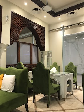
Cafe nearby مزاج مغربي
Saudi Arabia
Cafe nearby مزاج مغربي
مزاج مغربي
An Nada, Riyadh 13317, Saudi Arabia
contacts phone
:
+966
Latitude:
24.8146298
, Longitude:
46.6810329
larger map & directions
read more
nearest Cafe
47 m
وافل ارت
طريق الثمامة, الرياض, السعودية حي، Riyadh
Cafe
read more
273 m
كرك لذيذ
Ath Thumamah Road, Riyadh
Cafe
read more
429 m
قهوة رسلان
الرياض
Cafe
read more
478 m
قهوة رسلان
An Nada, Riyadh
Cafe
read more
479 m
قهوة رسلان
طريق الثمامة، الرياض
Cafe
read more
671 m
تشيمني كافيه
6906 5735، الرياض
Cafe
read more
671 m
Starbucks
مكتبة جرير، طريق الثمامة، حي النرجس، الرياض
Cafe
read more
672 m
Greer cafe
طريق عثمان بن عفان، النرجس، الرياض Uthman Ibn Affan Road, Riyadh
Cafe
read more
672 m
Cafe Liwan
6906 Uthman Ibn Affan Rd، Riyadh
Cafe
read more
672 m
Greer cafe
طريق عثمان بن عفان، النرجس، الرياض طريق عثمان بن عفان، الرياض
Cafe
read more
672 m
Caffe pascucci jarir plaza
طريق الثمامة، حي النرجس، الرياض
Cafe
read more
672 m
Caribou Coffee
طريق الثمامة، الرياض
Cafe
read more
699 m
Starbucks
Jarir Bookstore, Ath Thumamah Road, Al Narjis، الرياض
Cafe
read more
707 m
Alrifai
طريق الثمامة، الرياض
Cafe
read more
708 m
Dunkin' Donuts
6968 Uthman Ibn Affan Rd، Riyadh
Cafe
read more
713 m
Caribou Coffee
Ath Thumamah Road, Riyadh
Cafe
read more
721 m
Segafredo Zanetti Espresso
6906 Uthman Ibn Affan Road, Riyadh
Cafe
read more
721 m
BREW92°
Riyadh
Cafe
read more
734 m
Dunkin' Donuts
6968 Uthman Ibn Affan Road, Riyadh
Cafe
read more
773 m
Nabt Fenjan Specialty Coffee Cafe
8320 Uthman Ibn Affan Road، Riyadh
Cafe
read more
1.18 km
يبرين YABREEN
6157 ابي بكر الصديق, 2821, Riyadh
Cafe
read more
1.207 km
Rawashn café
Riyadh
Cafe
read more
1.297 km
ديرياسي كافيه عالية بلازا
Riyadh
Cafe
read more
1.297 km
ديرياسي كافيه
Riyadh
Cafe
read more
1.301 km
dr.CAFE COFFEE
Imam Mohammed Bin Saud University, Riyadh, Riyadh
Cafe
read more
📑
all categories
Accounting
Administrative area level 1
Airport
Amusement park
Aquarium
Art gallery
Atm
Bakery
Bank
Bar
Beauty salon
Bicycle store
Book store
Bowling alley
Bus station
Cafe
Campground
Car dealer
Car rental
Car repair
Car wash
Casino
Cemetery
Church
City hall
Clothing store
Colloquial area
Convenience store
Country
Courthouse
Dentist
Department store
Doctor
Electrician
Electronics store
Embassy
Finance
Fire station
Florist
Food
Funeral home
Furniture store
Gas station
General contractor
Grocery or supermarket
Gym
Hair care
Hardware store
Health
Hindu Temple
Home goods store
Hospital
Insurance agency
Intersection
Jewelry store
Laundry
Lawyer
Library
Light rail station
Liquor store
Local government office
Locality
Locksmith
Lodging
Meal delivery
Meal takeaway
Mosque
Movie rental
Movie theater
Moving company
Museum
Natural feature
Neighborhood
Night club
Painter
Park
Parking
Pet store
Pharmacy
Physiotherapist
Place of worship
Plumber
Point of interest
Police
Political
Post office
Premise
Real estate agency
Restaurant
Roofing contractor
Route
Rv park, camping
School
Shoe store
Shopping mall
Spa
Stadium
Storage
Store
Sublocality
Subpremise
Subway station
Supermarket
Taxi stand
Train station
Transit station
Travel agency
University
Veterinary care
Zoo
sublocality level 1
↑