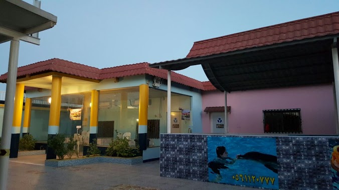
Campground nearby استراحة طيبة
Saudi Arabia
Campground nearby استراحة طيبة
استراحة طيبة
Al Jesh, Al Qatif Saudi, Saudi Arabia
contacts phone
:
+966 56 112 0777
Latitude:
26.5065034
, Longitude:
49.9897681
larger map & directions
read more
nearest Campground
3.589 km
الديوان العظيم
3772, Saihat
Campground
read more
6.118 km
Qatif Camp Alsaad
4107, Safwa
Campground
read more
7.906 km
أبراج السيف
Cornish Road, Saihat
Campground
read more
14.391 km
Al Qadee
2853 ثابت بن قمرة, Dammam
Campground
read more
14.473 km
استراحة الحصيني
Al Manar
Campground
read more
16.146 km
مخيم سنحان الكرام
Dammam
Campground
read more
17.969 km
al mouwasat dammam camp
8010, 3709, Dammam
Campground
read more
18.706 km
Azmeel New Camp Dammam
3435, Dammam
Campground
read more
19.21 km
Op_ Other Place Camp
Dammam
Campground
read more
20.675 km
Dammam Shipyard Camp
Dammam
Campground
read more
26.011 km
Al Amer Camp
7923 5ب, Dammam
Campground
read more
26.939 km
Raqa SCCC Camp
3268, 7894,, Dammam
Campground
read more
29.881 km
Labour Accomodation Age Steel
4590, 7326, Dammam
Campground
read more
30.174 km
Arabtec Construction Camp
Old Abqaiq Rd، الظهران
Campground
read more
30.262 km
Zamil Bachelors Camp Accomodation
Dammam
Campground
read more
30.264 km
Zamil Bachelors Camp 2nd Insdustrial
Dammam
Campground
read more
35.577 km
Half moon beach
3377 طريق الملك فهد بن عبدالعزيز, Dhahran
Campground
read more
37.472 km
Azmeel Camp
2677, 7045, Al Khobar
Campground
read more
62.405 km
Al Mutawa camp
Sami Khalil Street, Ezbet Abd Allah Saleh
Campground
read more
64.651 km
National Port Services Camp
4907 Al Jubail
Campground
read more
66.906 km
MdR Camp
Unnamed Road, Al Jubail
Campground
read more
66.947 km
Al Islam Camp
Al Jubail
Campground
read more
67.297 km
Nasser Hazza Camp Cape
Al Jubail
Campground
read more
67.463 km
HAMTE
Jeddah Street, P.O Box 1410, Al Jubail
Campground
read more
67.522 km
Al Maglouth Camp
Al Jubail
Campground
read more
📑
all categories
Accounting
Administrative area level 1
Airport
Amusement park
Aquarium
Art gallery
Atm
Bakery
Bank
Bar
Beauty salon
Bicycle store
Book store
Bowling alley
Bus station
Cafe
Campground
Car dealer
Car rental
Car repair
Car wash
Casino
Cemetery
Church
City hall
Clothing store
Colloquial area
Convenience store
Country
Courthouse
Dentist
Department store
Doctor
Electrician
Electronics store
Embassy
Finance
Fire station
Florist
Food
Funeral home
Furniture store
Gas station
General contractor
Grocery or supermarket
Gym
Hair care
Hardware store
Health
Hindu Temple
Home goods store
Hospital
Insurance agency
Intersection
Jewelry store
Laundry
Lawyer
Library
Light rail station
Liquor store
Local government office
Locality
Locksmith
Lodging
Meal delivery
Meal takeaway
Mosque
Movie rental
Movie theater
Moving company
Museum
Natural feature
Neighborhood
Night club
Painter
Park
Parking
Pet store
Pharmacy
Physiotherapist
Place of worship
Plumber
Point of interest
Police
Political
Post office
Premise
Real estate agency
Restaurant
Roofing contractor
Route
Rv park, camping
School
Shoe store
Shopping mall
Spa
Stadium
Storage
Store
Sublocality
Subpremise
Subway station
Supermarket
Taxi stand
Train station
Transit station
Travel agency
University
Veterinary care
Zoo
sublocality level 1
↑