Church nearby SYED SHAFIULLAH
Saudi Arabia
Church nearby SYED SHAFIULLAH
SYED SHAFIULLAH
Qurtubah, Riyadh 13245, Saudi Arabia
contacts phone
:
+966 57 037 5627
Latitude:
24.8088205
, Longitude:
46.7469174
larger map & directions
read more
nearest Church
3.416 km
بيت عبدالله الشهري
2935 صالح بن عمران،، الرياض
Church
read more
6.143 km
مركز ملاذ للفتيات
بوظا، الخليج، الرياض
Church
read more
6.32 km
البيت الاصلي
3726-3552 الاهوار، التعاون،, Riyadh
Church
read more
10.46 km
JLWCF PH4
3346-3264 Abdulqadir Al Maghribi, Riyadh
Church
read more
12.753 km
معهد مكنون لمعلمات القرآن بشرق الرياض
الروابي،, Riyadh
Church
read more
13.78 km
Ahmed Hassan
8344 Thumamah Valley St, Al 2897, Riyadh
Church
read more
14.906 km
معهد بصائر لعلوم القرآن والسنة
الجزيرة،, 7587 الاعتماد،, Riyadh
Church
read more
16.833 km
مكتب الدعوة والإرشاد بالمعذر وأم الحمام
Ar Radm, Riyadh
Church
read more
32.187 km
Elstraha
Riyadh
Church
read more
92.698 km
فصول نور البيان
Al Kharj
Church
read more
94.159 km
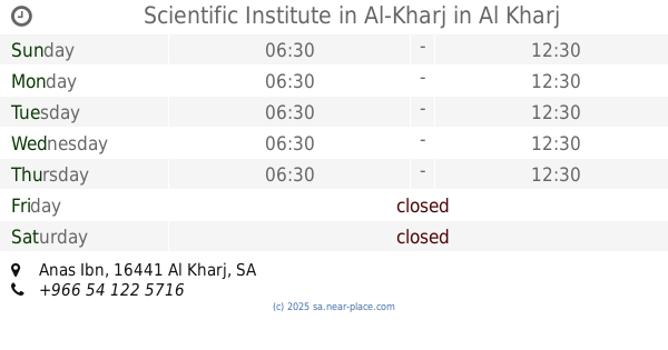
Scientific Institute in Al-Kharj
Anas Ibn, Al Kharj
Church
read more
310.542 km
دار تراتيل النسائية الصباحية دار المطار النسائية المسائية
8098 حي الشفاء عنيزة 56465
Church
read more
324.927 km
دار البشائر النسائية
3549, Buraydah
Church
read more
379.171 km
حسينية العقيلة
Saihat
Church
read more
379.637 km
مركز الهدي للتعليم النسائي
4427, 6866, Al Qatif
Church
read more
383.944 km
Hidayah Dawah Center-Lecture Hall
Al Khobar
Church
read more
385.817 km
حسينية الإمام الحسن المجتبى عليه السلام
Tarout
Church
read more
584.342 km
المعهد العلمي للبنات بحائل
8570 طريق الملك عبدالعزيز، حائل 55422
Church
read more
590.254 km
مركز حلقات أجا
حائل
Church
read more
684.115 km
معهد علمه البيان ببيشة
5202, Bisha
Church
read more
733.084 km
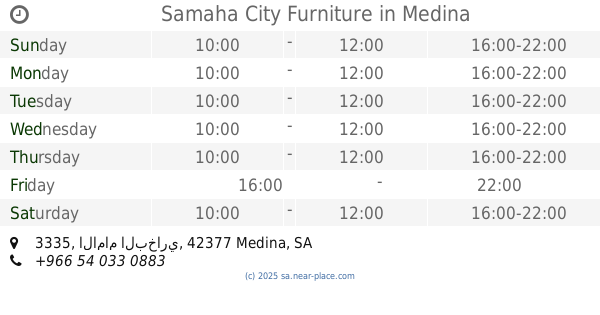
Samaha City Furniture
3335 الامام البخاري, 3311-, Medina
Church
read more
754.916 km
مصلى
Taif
Church
read more
761.341 km
Masjid
4593 Towen Center Al Bahah 65522
Church
read more
794.909 km
Camp 50 European
6815 Street 649, Mecca
Church
read more
794.926 km
Mina Tent
6962 شارع 649, Mecca
Church
read more
📑
all categories
Accounting
Administrative area level 1
Airport
Amusement park
Aquarium
Art gallery
Atm
Bakery
Bank
Bar
Beauty salon
Bicycle store
Book store
Bowling alley
Bus station
Cafe
Campground
Car dealer
Car rental
Car repair
Car wash
Casino
Cemetery
Church
City hall
Clothing store
Colloquial area
Convenience store
Country
Courthouse
Dentist
Department store
Doctor
Electrician
Electronics store
Embassy
Finance
Fire station
Florist
Food
Funeral home
Furniture store
Gas station
General contractor
Grocery or supermarket
Gym
Hair care
Hardware store
Health
Hindu Temple
Home goods store
Hospital
Insurance agency
Intersection
Jewelry store
Laundry
Lawyer
Library
Light rail station
Liquor store
Local government office
Locality
Locksmith
Lodging
Meal delivery
Meal takeaway
Mosque
Movie rental
Movie theater
Moving company
Museum
Natural feature
Neighborhood
Night club
Painter
Park
Parking
Pet store
Pharmacy
Physiotherapist
Place of worship
Plumber
Point of interest
Police
Political
Post office
Premise
Real estate agency
Restaurant
Roofing contractor
Route
Rv park, camping
School
Shoe store
Shopping mall
Spa
Stadium
Storage
Store
Sublocality
Subpremise
Subway station
Supermarket
Taxi stand
Train station
Transit station
Travel agency
University
Veterinary care
Zoo
sublocality level 1
↑