Clothing store nearby Oud Elite - نخبة العود
Saudi Arabia
Clothing store nearby Oud Elite - نخبة العود
Oud Elite - نخبة العود
Jazan Saudi Arabia
contacts phone
:
+966
Latitude:
16.9083117
, Longitude:
42.5477305
read more
nearest Clothing store
32 m
Blue Age
طريق الأمير سلطان بن عبدالعزيز, Jazan
Clothing store
read more
41 m
U-Mark Sport
Corniche Road, Jazan
Clothing store
read more
43 m
REDTAG
KADI MALL, SOUTH CORNICHE ROAD, JIZAN, Jazan
Clothing store
read more
47 m
It's Mine
طريق الأمير سلطان بن عبدالعزيز, Jazan
Clothing store
read more
54 m
Naomi
Jazan
Clothing store
read more
54 m
Ajmal
Jazan
Clothing store
read more
65 m
nichii
طريق الأمير سلطان بن عبدالعزيز, كادي مول, Jazan
Clothing store
read more
74 m
Ajaml Perfumes (Kadi Mall), Jazan
Prince Abdullah Al Faisal Street, Jazan
Clothing store
read more
75 m
Shana
كادي مول, Jazan
Clothing store
read more
94 m
تولي جور
Jazan
Clothing store
read more
103 m
Mikyajy مكياجي
KADI MALL, Jazan
Clothing store
read more
115 m
Stradivarius
Centro Comercial Kadi Mall, Corniche Road, Jazan
Clothing store
read more
116 m
Double Agent
كادي مول, Jazan
Clothing store
read more
126 m
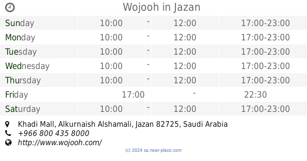
Wojooh
Khadi Mall, Alkurnaish Alshamali, Jazan
Clothing store
read more
139 m
Babyshop
Centrepoint, Al- Khadi Mall, Jazan
Clothing store
read more
139 m
O Baby
Jazan
Clothing store
read more
141 m
Suite Blanco
Corniche Road, Jazan
Clothing store
read more
146 m
Wahat Al Jalabiya
Corniche Road, Jazan
Clothing store
read more
151 m
Gingersnaps
كادي مول, Jazan
Clothing store
read more
156 m
Arabian Oud
Corniche Road, كادي مول, Jazan
Clothing store
read more
169 m
Marina
Jazan
Clothing store
read more
179 m
National Store
Jazan
Clothing store
read more
182 m
جولي
Jazan
Clothing store
read more
189 m
F & F
Corniche Road, Jazan
Clothing store
read more
200 m
الدخيل للعود
Jazan
Clothing store
read more
📑
all categories
Accounting
Administrative area level 1
Airport
Amusement park
Aquarium
Art gallery
Atm
Bakery
Bank
Bar
Beauty salon
Bicycle store
Book store
Bowling alley
Bus station
Cafe
Campground
Car dealer
Car rental
Car repair
Car wash
Casino
Cemetery
Church
City hall
Clothing store
Colloquial area
Convenience store
Country
Courthouse
Dentist
Department store
Doctor
Electrician
Electronics store
Embassy
Finance
Fire station
Florist
Food
Funeral home
Furniture store
Gas station
General contractor
Grocery or supermarket
Gym
Hair care
Hardware store
Health
Hindu Temple
Home goods store
Hospital
Insurance agency
Intersection
Jewelry store
Laundry
Lawyer
Library
Light rail station
Liquor store
Local government office
Locality
Locksmith
Lodging
Meal delivery
Meal takeaway
Mosque
Movie rental
Movie theater
Moving company
Museum
Natural feature
Neighborhood
Night club
Painter
Park
Parking
Pet store
Pharmacy
Physiotherapist
Place of worship
Plumber
Point of interest
Police
Political
Post office
Premise
Real estate agency
Restaurant
Roofing contractor
Route
Rv park, camping
School
Shoe store
Shopping mall
Spa
Stadium
Storage
Store
Sublocality
Subpremise
Subway station
Supermarket
Taxi stand
Train station
Transit station
Travel agency
University
Veterinary care
Zoo
sublocality level 1
↑